Typhoon Tip
-
Posts
44,236 -
Joined
-
Last visited
Content Type
Profiles
Blogs
Forums
American Weather
Media Demo
Store
Gallery
Everything posted by Typhoon Tip
-
guys, ... the 00z CFS ? haha... I mean it's not really a deterministic guidance type. No. But it was all about the 2nd wave
-
heh..the 00z CFS model was something else with the 2nd wave ( 14th) ...
-
One aspect I'd watch ... ( related to the 'under L.I.' precarious set up ) Pay attention to the fact that the spread is around the W-NW arc of this mean... with some deeper members ... Firstly, what an impressive correction toward greater amplitude this was ... But, this means there are probably some members with more deep layer trough descending bottoming out along that thinking
-
Yeah...Brooklyn' already commented - or someone did back a ways... But that was a huge lurch into a predominant lead impulse as taking the show. There's been wave space/negative interference - I suspect all along now that I'm seeing it actually. Look back, it's probably more culprit in why we haven't seen a more coherent materialization of this overall threat period, sooner - ...speculative. But showing the immense potential of bringing a match to a gas fight ... the slightest gap introduced between the two wave spaces vying for proxy on this sub-index scaled tussle (just meaning the actual S/W interactions), and look what happens to the GEF mean? If this comes in just a little more amp ... and were to evolve UNDER Long Island ( which it is damn close to doing...), this becomes more than a medium impact event with very quick correction
-
Well, of course… I’m a bigger fan of that tact. However, so long as people are “considering“ the icon solution, I’m just informing that the sfc is a piece of shit at least comparatively. But like you said the 500 mb and I also agree, because I pointed that out myself is like phenomenal.
-
It is but ends up, just sent out a memo that it’s a really terrible solution so I decided to scrub the whole run
-
Yup… See…? All you need is one good model run and “it’s all good“ I like Gasper’s statement, the sports columnist when he said “winning is the best deodorant”
-
Anyway, we’re just ping-ponging conversation tidbits about the modeling cinema describing whether we like or didn’t like the movie and who’s performances we think we’re better than others, and how well the writing the cinematography and all that shit went down. Lol. In that metaphoric neon, I would say that the 500 mbar was brilliantly written, but the acting at the surface leaves something to be desired.
-
Oh yeah… I can just cheat on my phone Anyway, I don’t really have a lot of faith in the icon as I’m sure nobody else does, but it would be amusing if it of all models were the one that kind of detect the reality on potentiality here
-
I'm in a meeting at work and can't really look but did steal a glimpse at the ICON ( which I have not faith in as a modeling tool but fwiw -) and the 500mb for the first of the two is every bit a realization as can be, with a slowing deepening pseudo cutoff below 530 dm, in an utterly perfect climate location to pummel NYC-BOS. whether the sfc concurs and other synoptic aspects ...no idea
-
This seems to be a cogent and valid impression of where things stand at this time, yup. I would caution, however, that it's not too late for amplitude to return. There's a pattern change really that is multi-dimensional. It's not just the immediate correction of the -PNA as it quickly rises over 5 days to 0 or even modest positive ( as well as the west (geographic) fade of the -NAO block...etc etc), but a very fast equatorial SST correciton and SOI reversal, combined with a unfurling of the powerful MJO wave space that is in 8 ... these are more indirect, these latter indicators, and they really should correlate better to a western N/A ridge response - it's certainly not harming the prospects... Lest we forget ... how often aspects can look rather dreary when relaying from the extended into the middle range for a stint. It's all 5 to 6 days away.
-
...when it was the EPS that first looked so impressive with all this back on those runs between the 3rd and 4th, too ... ...the more I look at this, it seems like even though the Nina appears to be rapidly decaying as we type, there's still some momentum finger prints in the flow, and it's somehow physically interfering with the onset +d(PNA) ... It's in both the EPS and GEFs, a -1SD to 0 is a definitive mode adjustment, but it may just turn out too shallow in the end.. hmm
-
It appears lesser and lesser likely that a solo 'big dawg' is going to emerge over the 12th/13th, despite the continuation of the over-arcing theme of the hemispheric outline - the signaling for the period of time is still shining. So we'll see if this is just 'pattern change' teen-ager angst in the models... heh However, there's still a robust indication from all three, EPS/GEFS/GEPs, for cyclogenesis along the M/A during the 11-13th, it's just not likely from what this looks like at this time, ...to become more than medium impact. It's also not beyond the realm of possibility that a significant enough low is spawned and stem winds just too far S-E and we watch an 'eye' like feature with an impressive gyre on satellite from just too far away ... rotating yet farther beyond reach. It's always a cruel lesson when something like that happens, because the signal is realized ...in full. Anyway, it seems clear to me that there is destructive wave interference emerging out of this so far. It is not beyond the realm of possibility that a solution like the GGEM's, which really doesn't perform with the leading (12th/13th) inject into the arena so well, in lieu of a much more impressive and meaningful impact cyclogenesis with that following - closer to the 13-14th as Heisy et al have observed of the 00z suite. It's ensemble mean is tepid on that idea, however. Everyone's seen the GFS's last couple of cycles ...and it's opting for the series of systems - we mentioned at some point along the way ... these signals can end up multi - to atone for this period of time. It really has 3 events there. It's managed to figure a way to get to express its native progressivity bias in the midst of a slowing pattern... pretty amazing actually. While the Euro seems like it just caught up between the two in that destructive interference and ends up failing on both wave spaces. Meanwhile, the EPS/GEFs seem to agree more on the first wave space related cyclogenesis as dominant, but those solutions are too shallow to be objectively considered major events - even though there are some deep members. It's not exactly a raging storm vibe when the trend of those numbers has shrunk, as well as the spatial presentation of the mean. It's seems likely to me that the ensemble means are also picking up on some negative interference. All and all ..it's not been a very friendly to winter enthusiasts, last 24 hours of guidance, as they are doing whatever is imaginable to construct the least realization out of what is suggestively still quite possible during the 10th through the ides of the month. That's just the reality ...or my take on it as of this morning.
-
See ... another aspect that is quite abstract that I'm toying around with in mind ... this signaled period appears to be dumping ( suggesting it will ...) a ton of mechanical wave space right into the seam of the seasonal slow down and wave shrinkage. It sort of is like ally-oop timing with that... The other side of this thing ( that 4 or so day...) we don't really go back to the longer wave lengths/higher gradient construct nearly as much. We probably enter seeing the seasonal evacuation. Relax! it won't be an instant thing. There could certainly be other thing trackable - but we should see a definitive difference in the wave space behavior. Big March events in the past did that same thing. They were stranded big signaled deals that were sort of 'left to their own devices'
-
Yeah... again - I am reluctant to buy into any one GFS run more so than usual for the time range in question ( which at D6.5 isn't a whole helluva lot of buy in, anyway! ) But the reasons why, the GFS has a progressivity bias that grows out in time. It's noted by NCEP as something future versions will ( hopefully) address. Well, the pattern we are heading into is inherently slowing down with less of that flow bias - that sort of isolates the GFS as having certain challenges handling this particular pattern migration.
-
A hidden variance/sensitivity in probability assessments that NCEP has developed that few people know about is the anti-correlation of Tolland CT... That gap you see there ? That is why CPC is enhancing the risk for actually getting an event up here at all - because tolland is left out of the cool kids and excitement.
-
Believe it or not ...it had this solution more so than less yesterday. It was deeper with the 500mb solution though, over ALB
-
uhhh what no. The only similarity either one of those two have to this is in the very real notion that winds and cloud patterns of all cyclones go round and round. You can't make a comparison to something when one side of that comparison doesn't yet exist for one. But for another, even if comparing the large scale ( hemispheric) antecedence, good luck getting a correctly reanalyzed series of charts from 1717 ( lol), or 1888 for that matter.
-
We're doing play by plays on runs that aren't ( individually) very likely to verify ... but, the Euro was slightly flatter with the western ridge after the impulse was ejected through. That is causing less total meridian (N/S ) structure to the whole field E of 100W ... such that this run gets slightly less constructive feedback. The 500 mb tracks slightly N of the 00z, ...the surface deepens at a slower rate, ... weaker response over all... All these are consequences. But again... these are are bouncing around for now.
-
I've often thought that would be a neat study...yeah. H. Archembault's papers/thesis work in the mid 1990s is the closest to that, but it doesn't go as deep, not parsing out the PNA's spacial and temporal magnitudes wrt to what storm events were observed - that kind of minute scale. Like a study that says, say, ' therefore 90% of 8" snowfalls took place between a +.7 and +.9 standard deviation +PNA' as an example? that would be interesting. Then, if you make that a three-way between the NAO and EPO ... the intersections would also be interesting. In general, though... most people with a-priori in the field know that at a baser level, changing index modes are correlative. I guess in a purer practical sense, does it really offer much more to have some series of algorithms that says 8" correlates in this x-y-z nexus of teleconnector convergence? Most of which is intuitive.
-
It's got wave interference (destructive). But I also feel - in knowing the GFS native biases... - that this model is not very well qualified to recognize the potentials embedded/native to patterns that are differentiating toward slowing down/curved structures. The success of a +PNAP ( getting more pronounced) implies W-E motions in the whole field are inherently slowing down in order for the emergence of more N-S meridian synoptics. Here's the thing... the GFS has a subtle, but non-zero/significant enough to be noticed tendency, to accelerate toward progressivity. Putting these two facets together, the former slowing down vs the latter speeding up, they are obviously competing aspects. It makes me suspect that the GFS is lesser likely to handle this particular D9 - D16 period of the month very well ( a broad brushed span of time in which these events are less conformed to faster flow in general - ) It's like the last system was in a fast flow pattern that is a better fit for the GFS. It may be why it stabilized into a stubborn continuity that lasted so many days prior to this event. Even though it ultimately ended up a bit too far S with cold and snow result ... different analysis.
-
Not to sound like a douche, but the impression of 500 mb height and vorticity loop ... where it ends on 144 doesn't require the actual sfc evolution by the trained Met/enthusiasts that know how the lower levels are forced by these mid level-type shenanigans. That's a chart topper look ... The 500 mb center, with its -2 or even -3 ST core, ends up in the Bite/abeam of NJ on the next frame ( most likely) and it's easy to envision a very, very deep surface consequence sitting right in the climate cross-hair for PHL-PWM. It can't really do anything else, if the 96-144 movie is correct Said deep low would probably capture and do a zig zag or backward yaw/hesitation or even loop somewhere off between the Jersey shore and ACK. So I guess of more pragmatic importance ... let's will those antecedent intervals correct - haha.
-
mmm ... Okay, tell ya what ... I'll give credit for the virtue of encouragement/positive re-enforcement along the collective psycho-tactic reformation ( LOL... haha) effort .. .but he still used the word Blizzard. I'm not sure there wasn't a kind of bargaining effort there that cons us into reading it
-
Bingo! I think the Euro in honesty deserves an honorable mention there. But this particular run/model may be the first to 'realize' the wave spacing arguments. Where and what precisely come of it ... yadda yadda yadda. I'll tell ya... this +PNA appears ( tentatively) to be relaying into a much better actual +PNAP ... unlike that Dec cosmic dildo paradigm variant ...
-
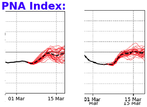
Hugely agree there ( bold)...As I was just expressing to OceanStWx ( Eric? I think it is -), I feel the primary sensitivity more relates to that handling. there is a change in the larger scaled wave exertion arriving from the d(PNA). when have the models ever been extraordinarily clever when it comes to handling a mode shift. ....this is yesterday(left) vs last night's(right) PNA ...it is showing both d(PNA) and +d(trend) This event really is an Archembault, ( after that research related to statistical correlations with indexes and higher scaling precipitation events over eastern N/A) recovery ordeal. That is a total 1 standard deviation rise over a short span of time, with a mass-field that is HUGE - sufficiently large in both respects, a major player is an entirely acceptable assumption. Adding in the west <-- fading black through central Canada, supplies a wave spacing negative geopotential anomaly argument right near WV give or take... so this all just timing perfectly, that a west eject trough would pass through that constructive interference region over eastern mid latitudes. That's what these telecons illustrate, without the actual advent showing up ( very well ...I'm not sure what the immediate recent runs look like - but given the din in here, the UKMET and may be ? ) ... just yet.