Typhoon Tip
Meteorologist-
Posts
43,840 -
Joined
-
Last visited
Content Type
Profiles
Blogs
Forums
American Weather
Media Demo
Store
Gallery
Everything posted by Typhoon Tip
-
OH that's clever. The seldom ever optioned, "I know you are, but what am I" retort - I think I'll double up my therapy apps for next week.. LOL
-
Will ...wasn't throwin' you under the bus, I just thought Ray's exchange was amusing when you followed it up so fast with an ICON post of your own. Both were trash talk, duh - Anyway, the 00z Euro and this 12z ICON solution ( hahaha...) are more back to an index-scaled suggestion. It doesn't make them right, but the idea of a -NAO onsetting mode change has been on the landscape really for over a week... So, it's like we have emerging solutions that have a plausibility - not just noise... We'll see
-
... stating the obvious ... The ICON solution can't happen because it has a band of choke snow 6"/hr rates over Methuen
-
See, everyone ? Will now has a secret ICON fetish ... For now on, we all know that it doesn't matter what 51 members of the Euro suite suggests for a storm a mere 6 hours away, in reality ... it's about what the ICON had for it last week. He's got the lotion and tissues set up awaiting by candle light ... while he pulse clicks on the ICON refresh button like a teenage girl exploring her mouse. LOL
-
heh... I like making fun of it. but, typically on here - anyone posts anything, it's become part of their 'street cred DNA'
-
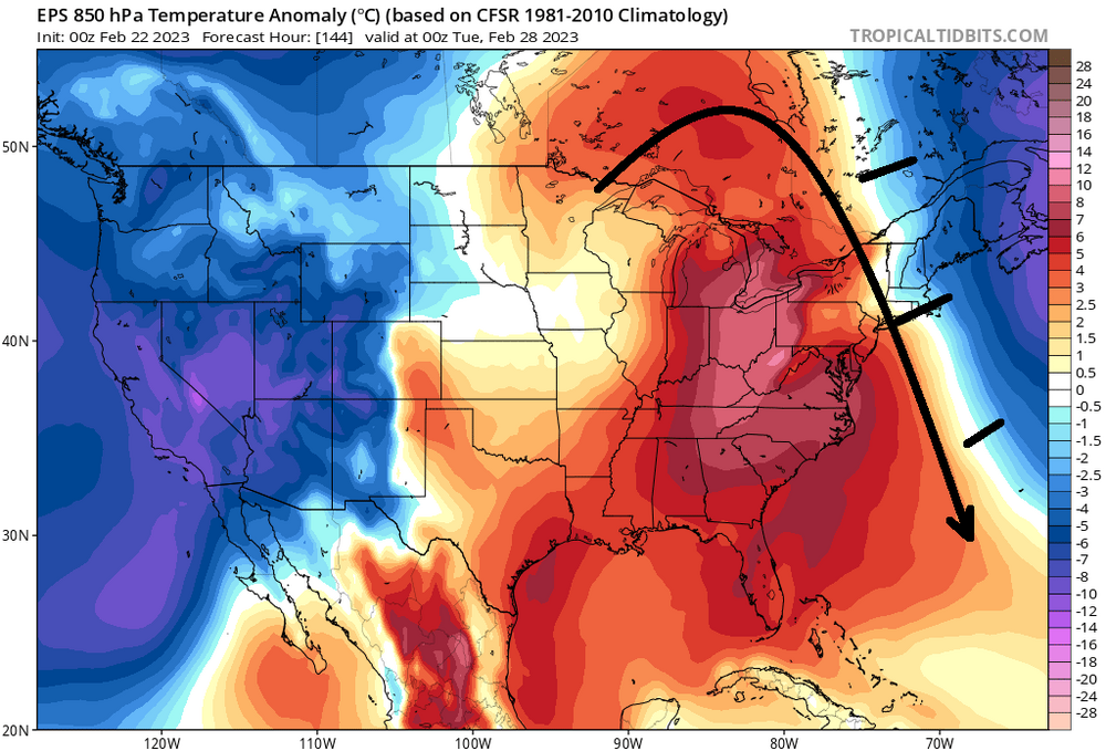
mm, it depends which suite one chooses to side with. The EPS' local hemispheric circulation mode, centered on the same range as these images you've provided above ... would not either allow that type of anomaly distribution you see in the GEFs, ...or if so, it would be deteriorating/normalizing with extreme rapidity Not sure I agree with 'siding' with the GEFs here... the Euro corp has a pretty damn good handle on NAO as a phenomenon over the years - possibly owing to the fact that the NAO's barrel points at that region of the hemisphere with even more scope focus than it does here as a general tendency. ...that prooobably leads them to needing to get that index under control. Just sayn' ..or as much as they can... I dunno. It's kind of like what Megamike was mentioning yesterday ...best to choose a source that's local, over one from the other side of the planet. It's like Earth telling Martians how to forecast their weather - ... fun metaphor. Anyway, here's the EPS 850s for that same frame. Clearly there is a resistance difference in the amount of NAO exertion by the two sources, and that warm anomaly region doesn't get east of the Hudson without attenuation in a Euro-esque proxy... Up to Met and hobbyists to choose I suppose.
-
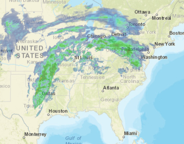
Setting the table on a possibly "moderate" impact winter storm. Perhaps the most promising event to date, this season. Presently... Radar upstream argues for a stronger precipitation loading than some of the guidance have been illustrating. However ... these rad looks can be deceptively over and under suggestive, either way. Therefore, that statement is not an aver for a big deal here...just that at this hour, that arc is pretty potent looking as it advances E into PA and matching that against the axis positioning by the guidance, it's not impossible that just ends up through the region with some higher fall rates. Combining...some of these recent guidances ( last hours) going colder with 200 mb of the sfc, is worth it to mention. Re that: the new NAM solution has almost doubled the Logan numbers, and I'm seeing an uptick out around ALB. Judging by radar return and overall lay-out, this is tentatively a nod to a better performance. While also cooling the column below 800 mb sigma Sat presentation has the abrupt ceiling advancing, shielding the skiess rather abruptly ...already so western regions. T/DP spread around the region looks like this, ..biasing the obs to NW-N regions because this is our loading source for the lower troposphere later this evening and throughout ( particularly) Thursday.
-
been in meetings all morning stealing glances.. sorry if this is covered - which I'm sure it must have been knowing this gang. LOL Just saw the new NAM FOUS grid numbers. Pretty chilly... coldest run for this mess I've seen out of that particular guidance. These numbers are all snow for 4-6 hours at Logan on the front 'wall' of this thing: 18037987363 07119 160914 46009798... this is .37" thru 0C 980,-3 900,-2 800 mb 24025987730 -1425 120620 48009602 The next period is .25" at 0, -4, +2 ...but +2 is not really enough to melt aggregate completely unless the layer is thick. I'm assuming there is a warm layer above 800 ...but not abundantly certain without looking at the NAM modeled soundings... Assuming there is, that is tall sleet column. This is near warning snow/IP combination totals at Logan just using these numerics and what they mean as a guide. Obviously, this is old school and there's modern other tech we use..
-
The ensemble means of all three... essentially parrot their operational versions.
-
The GGEM is hugely more in favor of the GFS overall... From this particular point in time and range, it's 2 against 1
-
Actually... closer look at the surface synopsis ... the GFS isn't a bad as that, buts it's definitely different and less favorable overall.
-
I spent 10 minutes observing the looping the stereographic layout of the NH off the deterministic 00z GFS and Euro solutions, and I couldn't really make out any reason to assess either as less likely regarding that 120 - 180 period out there. Which nests the 28th system ... It's important, because they offer world's apart difference wrt to that event. The GFS is a nod to seasonal trend, but has a progressive bias ( also ) regardless of said trend. It has the same eastern limb -NAO as the Euro ( they actually agree spectacularly on that specific feature out there by D6-7-8), but the effect it has on us, here, is the GFS doesn't transmit that effect. It keeps the -NAO influence more toward the outer Maritime and Greenland areas, and allows the Pacific/-PNA to proxy our events until much later ( that fantasy crap out there at 300 hours) The Euro seems to be responding more to the -NAO over the eastern limb, by transitively causing a slowing/trapping of the circulation features across the NW Atlantic Basin. This transitive forcing ( meaning it is coming from afar) basically back-logs the escape latitudes and speeds over eastern N/A, much more an expression of a NAO exertion comparing the two models. Thus, the local scale circulation mode ..and circumstantially advantageous to winter enthusiast, the mechanics of the 28th system ends up dumping a ton of snow across New England. The -NAO has a multi faceted support for happening -but when/where? Flip a coin ... not sure I see a reason why either is more likely than the other. Either we get 0 south coast snow to 4" of tired futility in the mountains out of the GFS. Or, something like 18-24" out of a slow moving, stalled CCB hosing into ample cold thickness, with 30 hours of S/W mechanics force fed under our latitudes.
-
Agreed... How that translates to the ptype gradient ..heh. But I feel ( still) that the correction vector for all this mess is still S oriented. "weather" that ultimately happens, it's more like leaning. The problem I'm also having is long years of experience related to seeing 1030 polar high with teens over single digit T/DP hanging over our latitudes by drain distance, with low pressure - however weak almost doesn't matter - rippling by to the S of us. Yet we stagnate at 33 F ... ? I don't know. The GGEM has a coherent tuck evidenced by the 2-meter, Thurs afternoon - the model may suck by street cred but this seems like a dead ringer for that. Maybe what you said, is just unique enough for a cold bust.
-
It's lala range anyway but ... that solution is also shirking D.C. to Maine out of a 30" history bomb
-
All I needed to do is op-ed an 8 paragraph rant about 'pumping the 28th breaks' because the NAO was backing off ( this morning...) and now during the day ... we start going back the other direction. see? all one has to do is bitch and complain and there we go. LOL No but that's about an ideal look for 'balancing' the -PNA with -NAO. It's a narrow window that we really need to work out, for this recouperation idea... Otherwise, heh... But it is what it is and we'll see. That said, the 28th is still a dead deal to us, because this NAO is just that delay I was talking about. So, whence we arrive upon the 28th, does that then get delayed again? God ...I hate the f'ing index
-
All we're doing in here it pointing out the very typical oscillations that happen to everything that is ever modeled. Step back and look at it from Orbit...this has been solid and relatively unalterable since a day ...day and half ago. Every storm that is ever modeled, no matter the scale or the intensity, varies just like this - typically... no one notices, because they are safely inside the threat area where such minuscule movement are irrelevant ... thus, unnoticed. In other words, it's unlikely to be an indication of this moving en mass N or S from here on out. These 'giga' motions are going to take place in the guidance output, right through verification. You'll know if this wholesale makes a definitive move.
-
mm... all years combined perhaps. Our arena this year and the antecedent/leading indicators wholesale, changes that idea a bit in my mind. These 70+ rolling warm balls through the M/A are may just be a harbinger - Or not ...just sayn'
-
no idea


