

Typhoon Tip
-
Posts
44,236 -
Joined
-
Last visited
Content Type
Profiles
Blogs
Forums
American Weather
Media Demo
Store
Gallery
Everything posted by Typhoon Tip
-
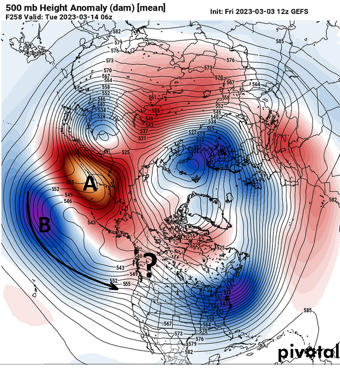
Sure... the following Mar 14 outlook by the GEFs mean qualifies an exceptional example of the 'AB' phase of the Pacific circulation mode taking over by then. That is big difference than what is occurring now, which looks more like this... The AB phase below on Mar 14: typically throws up higher heights down stream ... it's why and when the North Pacific is in the AB, that highly correlates to cold anomalies over N/A. Now, ...this particular AB construct that we see above only couples to modestly ridging down stream of a pretty impressive looking AB signal. That's perhaps correct-able in raising heights in future runs. But that said... there's no cooky cutter snap fit anything about this ( just speaking to the general audience here). I would only argue the correction vector is higher heights over western N/A. Also... I'm noticing the AB axis might be situated W ... I'm like, what the f*k is up with this west biased shit this year. Jesus Christ... in any case, that's the first ( I have seen) AB synopsis, and given it is onsetting...that obviously enters uncertainty in either direction with exactly how the western N/A heights respond down stream. They should ridge, teleconnectors are meant to be broken, it seems, as just a fantastically delicious aspect of CC too... whole 'nother discussion.
-
It's unfortunately ... ... not impossible. However, I personally can only offer that beyond D7... particularly 216 hours, the Euro tends to shorten the longitude of wave lengths while increasing the total curved nature of the flow. Meridian biased ... It used to be more obvious years ago. But that gobbled up super massive Sagitarius *A star black hole of a vortex, 400,000,000 times the mass of the sun and parking it over Dubuque Iowa like that strikes me as the Euro buckin' for enough curvature to bend the arms of the Milky Way Galaxy. But that's hardly the thesis intro to a scientific paper, huh -
-
I'm not actually sure on the MJO's input ... I realize it's surging into Phase 7--> 8 as we type, but it only spends an intra-weekly time span in that space before all the guidance contributing to the RMM are showing it nose diving toward the lower skill momentum ... It never really gets through 8, into 1 It may just be an artifact of a new emergent wave momentum/propagation, it may start 'unfurling' ... But until that's indicated, the current outlook smacks as still kind of running into some sort of broadly destructive interference. It's about momentum. If the wave does not spend much time in the total 8-1-2 region, it's total integration is weak --> implies less coherency. One would think anyway. No where else in dynamic physical nature is Newton's First Law, 'An object at rest stays at rest and an object in motion stays in motion with the same speed and in the same direction unless acted upon by an unbalanced force,' better demonstrated than by atmospheric mechanics. Namely...pattern/Rosby dispersion. If the MJO is insufficient to act on the on-going regime, ... it doesn't act on the on-going regime. It's actually remarkably simple. Anyway, with that conceptual shit in mind... I just need the wave presentation to look less weird like these big curlycues
-
I 'think' what he may also be dancing around ( and I'd agree if so...) is that we may not really "need" a big ridge? ...It's really all about less resistance. Actually all events are constrained by that... But in this case - as you've pointed out - the previous examples (this year) of +PAN were skewed west enough that resistance to mobilizing troughs through the E was higher and well... never happened. Not really. Sometimes the presentation of the ridge belies whether or not there is lessening(growing) resistance. I suspect the ridging all ready prevalent in these runs nods to that, as the axis is (thank f god!) actually over the land mass of d-damn continent for a change. Scott's right though about the decaying -NAO over H. B.
-
Thanks Sey-Mour ... it's interesting that although the spread is large (geometrically), there are members in there below 970. Yeah, I didn't include these ensemble spread products because there's enough already in that missive to send folks to their Sumatriptan
-
btw, I create a thread for that focus... just letting people know its there. It'll probably be back seat until the afterglow (or jilted rage...), fades off Saturday night but it's there nonetheless..
-
Been ribbing the forum for a couple of days on this aspect ...agreed. Hyper vigilance to detect reasons to poo-poo is about as useless as calling every cumulus cloud on the charts a 10 ten blizzard, though. Okay, so maybe the latter is worse...but still - it ain't helpin'
-
Yeah ...I know. That clipper next Tuesday has been gaining identity in the GFS every run going back some 7 cycles. 'That's what we call a trend, class' I don't like the QPF loading with a NW-SE moving S/W that doesn't/didn't have access to a PWAT inject prior to arriving here. But... I remember a 'little critter' like that ... in February of 03 that shocked the shit outta NWS and sent them scrambling to get a Warning out down the east end of the Pike when 10" , on a west wind no less, laid down over a white home page on their web address while it was happening .. heh. Come to think of it, that's might actually be the greatest positive bust ever, because it went from "0" to 10" ... We can't be tossing these things like they don't count. And we may also just be in a small 3 week window of, 'if it can happen it does' results. Go figure! we'll see.
-
I realize the system here in the foreground needs its attention bandwidth ...but I'm a dork haha Man, there are some WHOPPER attempts just exploding onto the charts out there. Granted, they are largely eye-candy being that they are D8+, but you know. When we are establishing a baseline powderkeg in a 10 year old's club house of explosive potential and some point ... so much eye candy starts to make one wonder. However so ... I do suspect we are seeing a rather quick emergence in the Mar 11-13th range.
-
The NAM's FOUS has that implicated 24064978517 05516 970937 46009800 24076995607 -2611 900203 51050400 ..E at 37 kts! 30037978622 -3520 940435 42009798 30001886004 -0118 973314 45040097 ..NE at 35 kts! 36010918128 -2824 073624 34999491 By the way...also colder than the last run. No interval is above 0C beneath 800 mb level... Now...obviously the NAM likes to string hammocks and open the tiki bar at 725 whenever it can, so ...not sure about that elevated sleet column scenario. But the QPF in the left columns is over an inch. just some offering this -
-
GFS'll be interesting in that detail... ...I noticed it was inching closer and stronger across the last several cycles - minuscule amounts, but a dependable 'stolid' (won't be deterred) trend. It's almost a comedic underpinning to this that only a nerd would understand ( LOL )... the GFS is just getting fought by all guidance for any gesture it dare put forward at all - wow I almost want it to verify just because it's being targeted for abuse like a red headed step child at a 'how to f-up a kids life' convention
-
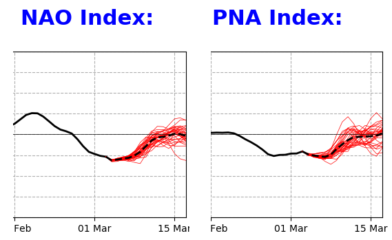
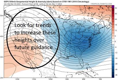
There is likely at least tacit awareness to this, already... something large is implicated. Precisely where, whence, and amplitude/scale ...not withstanding, but that week as we approach the ides of the month is quite saturated with signal. A major event is not a declarative here; however, we are in a highly prone scenario between the 10th and 15th of the month. The idea for this is an early thread for general awareness, but the upside correct-ability of events in that time range is quite a bit larger than anything since the Buffalo massacre back in Dec. Though I would be disingenuous if claimed no intrigue at the deterministic Euro, GGEM, GFS ...all making a first attempt at detection, resulting in a kind of buckshot spray of bombs - it's interesting that we typically do get a spray of systems.. but it may be no coincidence that they happen to be very powerful features considering the facets below. They all have a massive events emerging, but unfortunately, these attempts are too primitive. However, the behavior is vastly more important than specificity at this range ... probably for the next 3 days ( although, I'd venture, if a system emerges in a large enough signal, the models will tend to detect earlier). I would not be shocked ( hint hint) if the 11th and 13th get bright - That said, I would watch these D9 ..10 emergence with more open mindedness than the usual auto-scoff. It is also possible that this period would results in more than one event, each less magnificent -so to speak... Super synoptic: The idea here is a fade in the exertion of the NAO, in tandem with a +d(PNA)... These are not just spatial interpretive, either. For the first time since leading the Buffalo event... the observations are both spatial, and numerically indicated in the teleconnector computations. -(NAO) --> + d(NAO) +d(PNAP) ... Which are two, in tandem modal states that has been highly correlative to major events ... ever since these indexes were purposefully codified. Considering the PNA, in totality we must consider the actual synoptic mode over the continent. As we know...the PNA domain's geography is truly immense. The index can be negative(positive), but because a lot of the index domain space is situated over the Pacific, these above numerical equivalence of the index may(not) represent as well over the continent, and vice versa... In this case, that rise in the PNA may actually be doing a disservice to the interpretation over land. The rise is well concerted and achieves a +1.5 or so ( and may correct greater), but, more importantly there are increases in +PNAP ... Real ridging now propagating into the W in recent model tendencies, during the above hemispheric changes .... That is like taking a lit match into a gas fight. For right now... there is a spray of big events depending on the model of choice. I am fully convinced this is merely the deterministic guidance versions just 'detecting' the immensely unstable numerical layout of these larger --> shorter scaled forces, those that tend to require major restoring ( index scaled ) events. the 00Z deterministic Euro and the GGEM have almost immediately detected in their extended/respective cinemas. Again, I don't care to comment on the accuracy of either movie - its more important that they have a show. The GFS has less in the early temporality but goes eye-candy well over the performance horizon. The 06z see started moving toward the 11-12th, where there are bigger signals by the others. My hunch is that present ensembles also beginning to show some concentration in the 10 thru 13th is probably a good place to start.
-
NAM's 06z was 08 over Logan at mid BL, and going N from there... just sayn'
-
oh well.. yeah. sorry Scott - right. I mean at a regional scope. In the context of imby, if one is located 10 mile NW of the Bourne Bridge or whatever, they're not likely to get the same realization as ORH. Lol... which in turn isn't getting the same thing as Keene, NH either..
-
Although, within that framework ... I then am willing to correct downward the GFS 15 to 19" snow totals. But the 20% modulation in probably helps that... I think 10 to perhaps lollypop 12" will be the maxes.
-
Gosh... you guys are a needling reasons to not accept this as a decent event. I guess truth be told, it's impossible to remove the humanity from the "geo physical equations" that proceed the modeling of any event ... Still, I'd just caution, needling for any plausibility that sides with the most direst of indicators, is just as unseemly an application of bias. It's clear some kind of defensive blah blah blah, must be motivating that tact. I'm still going ... 80/20 in favor of the GFS, with the 20% sort of a consensus of other tools. For as purposeful as those 'plausible' anything in this may seem, I don't see them as compelling reasons to assume an "optimistic" result is unlikely. I warned...btw way ... not to allow past winter's shenanigans dictate one's perception when we started this thread. And that seems to be failing - imho... just observing this practice.
-
This isn't an analog for that event - beyond the fact that they both have low pressure producing winter storm conditions on the map... I mean, not that anyone is saying it is, here.... I'm just gathering cognizance for the morning. Not sure what planet I'm on just yet... But I do know that on Earth, that system was unique and different than this. just sayn' That storm brought 6.5" to Acton, ma in one hour during the 4 hours of the total event. We ended close to 15" There were to concentric bands ...probably separated by a gravity wave.. As each one passed over, vis went down to feet. 12/9/05 was 2nd time I ever saw 6+" in one hour, the first time was 12/23/97.
-
NAM FOUS 06z was colder, period. Logan with -0C isothermic all the way, with only one interval at +1 in the lowest level through the event. Also, it's 62" liq equiv, with ENE wind at sustained 34 kts at 980s mb above the surface. That sounds pretty darn close to a blizzard like arena - but obviously we know better with the frothing open sea delivering that "CCB" Which by the way, ENE at that wind sustained over several hours, and low < 990 going underneath is a CCB. Not sure if there's still contention on this idea ... but if there is, the NAM's 06z looks darn CCBish for what it's worth. Haven't seen any posts since 7 last night so I have no idea if all this hasn't already been demolished through the interpretation net - haha.... funny feeling it has
-
The NAM FOUS at 36 hrs looked like Baffin Island out at Logan. .73” under 0C in sustained 40 mph It’s been consistently looking like that. Snowier in the numerical profile than the synoptic charts illustrate.
-
Yeah. I wouldn’t care to aver a prediction for the whole month … but at least through the ides … blocking appears to be the course of lesser regret. I mean in practical sense … I suppose if the NAO takes 7 to 10 days to mature and fade … then the EPO loads into an elevating PNA after that … where are we going. We end up nearing the equinox.
-
The NAO fades as a new -EPO formulates. That temporal relay et al is pretty good indication that a blocking hemispheric mode is still in place.
-
Part of me would silently enjoy, if it absolutely crushed all the other guidance, and ended up perfectly right. Muah hahahaha
-
I lived there in the mid 1980s when the dinosaurs roamed... brutal. Although, there wasn't much of winter anywhere in 84-85 - that I know of... But we did have a couple standard Nor'easters that winter and the geek-out over the surf and power of the ocean is actually well worth the admission - you just have to suspend any interesting is snow. We did get one one storm that season though that had 4-6" to go with folding walls of wave power, but it was at the aft end of January after a brutal cold snap - I remember the arctic sea smoke at dawn one morning, with the sun rising behind, back-lighting translucent steam dogs as they roamed back and forth like they were on patrol. It's not a snow climate you appreciate out there. You leave all expectations behind when passing the Fishery factories from the mainland side of the Penn
-
consensus shifted S... what can I say - I mentioned this morning that the consensus could certainly move, and that's apparently happened ... immediately upon that next ensuing run. Heh. This obviously increases the odds ( from a pure modeling reliance - I was never completely sold on the consensus from overnight's runs when I posted those statements this morning..) the white over wet profile implication for that band between rt 2 and the Pike...If fact, pretty dramatically so. Still, we are dealing with gradated set up. You may observe S+ and be on the phone with a pall 10 miles S of you and he/she is reporting R+ with cat paw wad rain drops and one or two pingers. But that transition is now pretty clearly south HFD-PVD ...perhaps even Willamantic CT to PVD. I honestly lean toward the GFS as just having a better handle on this from the get go, and that we've wasted life energy in consternation all week - Either that, or it will be the most adamant bust in the history of model stubborn insistence. Thing is, I can see reasons ( still ) for the previous NAM/Euro and the GFS runs, and still do. But, all things being equal... one side of the debate is giving up.
-
Be leery of the models handling the secondary development rates -


