

Typhoon Tip
-
Posts
44,244 -
Joined
-
Last visited
Content Type
Profiles
Blogs
Forums
American Weather
Media Demo
Store
Gallery
Everything posted by Typhoon Tip
-
I don't know if your kidding ? ... anyway, the numerical representation of weeklies has a favorable spread... AO is modestly neg/EPO is modestly neg/PNA is modestly pos ... I don't normally employ the EWs but just cause you said that I admitted to looking. LOL. sue me. anyway, cheers.
-
Heh, there's a real signal on the 30th, though. Of what will show given time.
-
I hope the heat rifle loads up like this in early May ... +25C at 850 mb over southern Manitoba - no problem I mean ...this is eerily a +PNAP flow structure down stream of a +PNA surge ... resulting in that - wow
-
Yeah I’ve noticed that whenever the northern stream pulls N of the border … flopping kicks in among all the ens sources actually. I remember Scott and I were talking about this last month when we went through a period whence there was almost no predictability. It seemed like every two runs there was a wholesale different hemisphere look construction. I don’t know if we’re that bad right now, but it does seem like the entire area below 50N has opened up and populated with jet meanders more so than an identifiable main circulation stream. It strikes me as odd during an El Niño… Where the hell is the STJ been.
-
Not sure regression has much to do with
-
Hahaha best ball bust post ever
-
What George appears to be demonstrating in his responses is quite common among the plebeian perspectives over ...pretty much anything in reality. They stop their analysis at whatever is downloaded through their god -given USB ports: sight, sound, hearing, touch or taste. It may be an aptitude thing? It may be an emotional thing clouding judgement...? But either way, both are commonly found in the commoner ilk of intellectual limitations: they don't do as well with nuanced thinking, particularly if it has to process observed information that they don't even really understand the origin of in the first place. So, ...in essence, you're engaged in an non-influence-able discussion with someone incapable of 'getting it'.
-
12z GGEM 'detecting' the 29/30th system chance ... The long lead is caveat emptor. But there's a robust PNA -driven signal for that period of time.
-
The 06z GFS attempts to materialize the Jan 30 signal I was mentioning the other day... (finally). I mean it's been the telecon suggestion for awhile but the operational dailies didn't reflect it. In fact, last nights numerical PNA projection was even more impressive. It's actually huge. The only problem is...where the f* are the polar indexes? They're apparently in hell. AO is soring...and the -EPO has been lost. Typically the AO and EPO will move together as they share domain space. But...there is a partial disconnect. Some times the EPO(NAO as well) will part index modal company with the AO...etc.. It's dizzy logic. But the EPO index was indicating a negative burst around the 27th; since yesterday morning ...it's neutralized. So, neutral (even modestly) positive EPO under a raging hard-on +AO ... mm, doesn't send a cold signal. What we have working in favor ( maybe ...big maybe ) is the climatological nadir. We rock-bottom over the next week and then slowly start going the other way, so all this above may be able to "manufacture" ( whatever that means )... Needs lots of work. We need this chart-esque to continue to evolve, and then cross the cold air supply bridge later I guess.
-
Bad timing ... I'm being ( or trying to be ) objective in my contributions this morning - it just so happens that it coincided with a daily vibe I wasn't aware was happening when I wrote about the CC aspects. Ha. Sorry guys. I still think there's reasonable chance for some snow on the 24th, fwiw. NNE is the best shot but CNE is in the hunt. Maybe down here...
-
Yeah... not to make it about me but really, I haven't once talked about temperatures across the themes of my posting this winter thus far, in any limitation schemes. I've never thought we had a lack of cold air; limitation has been the access to colder air. Even if the above panel is derived because nights were this or days were that, and the ending averages somehow belie the truth of temperature distribution in some way ... I very vividly recall plumes of sub -10C air expanding across Canada below the 60th parallel to know, it's just a matter of if the circulation mode over the continent gets it far enough south to do the deed. I've had three separate 14", 2" and 4.5" totaling my snow season thus far. I'm thinking I may be a little behind average to date? But based purely on scalar comparison, that's not sufficient to justify grousing if being fair to expectation. Wanting and pining or heroine ague withdraw syndrome ... those are not part of that "fairness to expectation" model. So maybe in the SE zones and along S CT/RI they are farther behind... Otherwise, if folks are manic when not being above normal for snow, no sympathy. If one's quality of life is being affected by model cinema not triggering the right way? - not joke, they should seek some sort of council. I'm curious if the 24th overrunning works out. I've seen those burst to 6" where's more snow over cold rain types. Suddenly, I'd be nearing 28" - ... But you know, if it didn't snow again I'm weird. I'd find that interesting.
-
HAHAHA... ... but just in case... please don't couch me in with the "Gretoscracy"
-
I have 0
-
I think so... But with the oceans warming at a faster rate ( recently ) than the 30 years trend line ( in other words accelerated rate ) that makes attribution difficult to parse out, which and what owns what. I feel the circulation changes over the last 30 years in general are occurring are too plausibly connected to redistributing the SST. That should be automatic ... Change the wind patterns --> changes that sea surface stressing model. If we can't see that much wrt to than Darwin's already won... (the actual trophy awarding happens when we pretend the anthropogenic CC forcing isn't the cause) But, look at what happened last spring. The oceanic surface anomalies everywhere ... spiked. And, stayed there. The PDO is a moving average. The (-) vs (+) of that longer term teleconnector are based upon very long term seas surface temperature normals. I'm just having trouble with the arithmetic of even using the -PDO, because these above aspects causing the "negative," appear to be modulated too fast( faster) for(than) the longer/multi-decade basis. What it all boils down to is that the -PDO right now ... doesn't mean the same implication on the weather patterns that it physically did back in 1950. Probably not the same as it did in 2000, given the last 20 years of explosions in heat d(rate) being observed. I don't think the current -PDO is driving these current pattern headaches ...etc. The -PDO, and the heart aches, are both a reflection of something else going on, and that something else is most likely CC general.
-
Agreed... I feel as though the speediness of the basal flow across the hemisphere, as well as the -PDO ... etc, are at least relatable to the facets found in this paraphrased reprint, https://phys.org/news/2024-01-climate-south-china-sea-global.html "...Researchers point to the predicted changes in the Hadley circulation as an example, which is a cell that connects the tropics and extratropics. In a warmer climate, the ascending branch of the Hadley circulation would become stronger and narrower, while the descending branch would shift poleward..." The implications on the mid latitude is that there is the increasing gradient in the boreal winter, a posit I made on my own back in 2010. Heights and warming is occurring in the polar regions at 3X's the global rate ( 1.5 to 2X's the global rate, but recent findings increased that to 3). However, that rate of change hasn't yet crossed a threshold where the total D(HGT) between 70N and 30N falls below increasing geostrophic wind as a compression response. There was an earlier ( half decade ago at this point) IPCC report ... chapter 5 discussed implications. The HC was notably expanding ... but they also attempted to limit that to summers. I found that to be dubious. I didn't believe that part of it would ultimately prove true. They appeared to be basing that on the observed termination latitude of where the HC boundary smears out into the westerlies... However, it is an easy math conversion to show that spatial release in winter, is actually converted to mechanical energy... in the form of speeding up the flow. Trading. It's okay though ... since then there are papers that describe the jets as increasing in velocity (now) ..which I feel was academically missed by the 2017 report background. That's the nature of a new frontiers of science. There are going to be suppositions and postulates that turn out to be both correct, and incorrect ... and around and around we go. I think the speeding flow and increasing wind is distorting SST anomalies over the Pacific northern Basin, another among a new ( or new-ish) aspect of the CC implication envelope. Add that to the list. That, AND... it is also physically proven that 90% of the warming in CC has been absorbed by the oceans. Despite the increased killer heat waves and record general warm episode headline frequency, world over, spanning the last 20 years, those are atmospheric.
-
It's almost like whatever form the scenario(s) next week take(s) aside, they were created specifically for the purpose of tormenting weather-charting-psychotropic drug addicts. hahaha. I mean ... it may snow, it may not. But it CAN snow, and saying it can not ... is false. Yet saying it will, is equally false. This is akin to backing food truck up to the prison gate at Auschwitz, parking it there and walking away.
-
Global cooling
-
00z GFS ends that run in full spring from Texas all the way up to Kansas. It's just as less likely to occur as a big snow event at that range, of course. But I can tell ... as a veritable Rain Main when it comes to cataloging historical weather charts in the brain that I am, you can trust me when I tell you that 570 dm hydrostatic heights ballooning to the latitude of Kansas on February 4 is weird - I don't care what range it is...
-
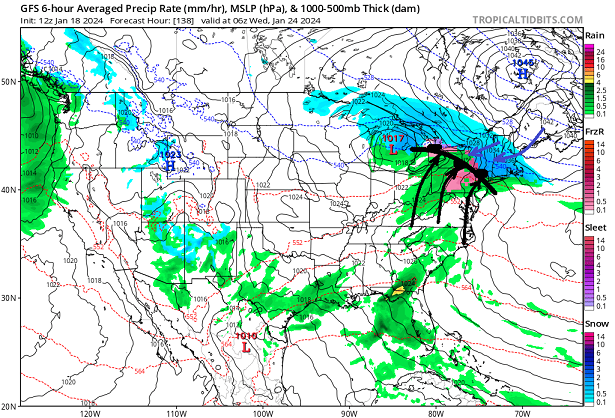
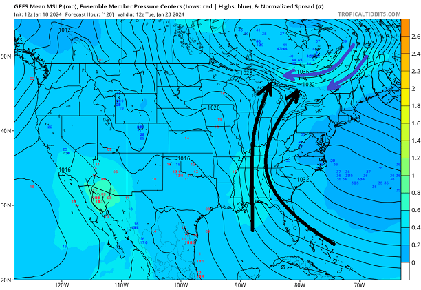
I already think it is ... It's got overwhelming support now in the ensemble synoptic evolution through that period. But it's easy to see why it's setting up along the lines of 'synoptic theory'. We have had an active N branch for the last 10 days ( bringing cold to the middle latitude continent and so forth...), and it abandons, but doesn't retreat fully. It really backs out to about 55 N... but this is a base-line confluence result. As the +PP structures and moves by to the N, it's going to have to instantiate an isentropic lifting interface where the return flow around the oriented ... well, fuggit - here this is the preceding day, the 23rd... you can see the the return flow is likely happening whether this high builds in from the NW or not... *BUT*, because it is... the overrunning is caused by the high obtruding into the region as the return flow is then forced to intersect. The next day, ... boom- it's really the high pressure that causes this to happen... not a low pressure in this overall scenario.
-
I'd also watch this period here ... Nothing specific for now - just you know ...future guidance, keep in mind.
-
yeah... well, that's why I suggest a combination of 'deck loading against,' together with bad luck. It's impossible - probably - to parse out how much is which -
-
I get the frustration - not meaning to be insensitive ... But the deck is increasingly loaded as the years go by, wrt to that sort of 'give us a break' failure. The expectation should be that it is getting lesser likely to observe those kind of stretches. It's happening at some rate - whatever that is, I don't know. It's probably a combination of bad lucky, with "climate cards deck loading" ... but the proportionality there in? good luck figuring that out.
-
Firstly the Euro Weeklies is up to the user for inclusion in any outlook ... I wouldn't fwiw. Secondly, the flow structure paints a different picture than the color distribution - I would hope Allan takes that into consideration ... but I don't know.
-
All this beady-eyed frenetic tapping and clicking on these model runs for a futile lost cause ... haha. It strikes me as the seen in "Princes Bride," whereupon Count Rugen was admiring the pain he caused and as Wesley above all else still rises to his feet, ... Rugen says, "Good heavens! Are you still trying to win?"
-
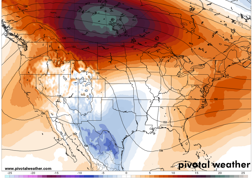
That's actually a high amplitude +PNA. Lower heights N/NE of Hawaii, higher heights over western continent is the hallmark of +PNA. Only that Euro means is very deep and widely integrated N of Hawaii, terminating into a flatter western N/A ridge... The problem is, the amplitude is there but not expressed in the N-S(meridian). This is a problem of fundamental physics ( really..) in that higher velocity tends not to go around sharper angled trajectories. When the flow is gradient soaked, and thus fast ... the curves in the flow tend to stretch like that. I'm just commenting on the pattern foot...


