Typhoon Tip
-
Posts
44,244 -
Joined
-
Last visited
Content Type
Profiles
Blogs
Forums
American Weather
Media Demo
Store
Gallery
Everything posted by Typhoon Tip
-
Not to be a dick ( seriously ) but this has never impressed me so much when that happens. As we move from autumns into winters ... often enough the first cold intrusions are provided by a -EPO. Half of which plumb heights down dramatically W of 100 W. That type of scenario drills cold west first - probably happens more times than we may think (historically), from mid Novies to early January?
-
In a transitive ( non- linear influence) sense of it ... GOOD! Because I've become leery over the last 24 hours that this -NAO is causing problems with our two events, the 16th and the 20th. There's too much compression in the heights through the integrated manifold, between 70 N and 35N ... over the eastern continent. The flow is physically speeding up as anything attempts to inject into that region ( you know this - just commiserating here...), and that acceleration is absorbing the native mechanics of any S/W ... If the S/W can't impose it's own forcing in the field, no storm. Instead, we end up with models being dense ( stupid ...) about the speed of the flow and having to then speed it up. They have to destroy their own cyclogen parametric/resulting design, as the mid range torpid flows become realistically bombastic in the nearer terms. These models are perfect for prick tease as a technology when it comes to this weather model cinema for joy engagement. LOL
-
Fun article ( in a not so ha-ha way) below. Tfwiw - "2023's record heat partly driven by 'mystery' process: NASA scientist" "...It wasn't just a record. It was a record that broke the previous record by a record margin...." It does beg for a deeper causality explanation than can really be offered given the present day manifold of scientific knowledge. Personally I'm inclined to think this "emergent property" we just witnessed is no different than what happens in every complex physical system that exists inside the realm of universal reality. The more complex the system, there more potential there is for "unintended consequences" - they spontaneously emerge as non linearity (byproduct forces that only exist because two or more linear forces are interacting) becomes sufficiently large enough to abruptly accelerate an observable expression in the field. Because of their erstwhile inherently elusive existence, that bursting forth seems to come from nowhere. The possibility of unintended consequence, or emergent properties is well enough hinted in Schmidt's later omission, "...It may be that El Niño is enough. But if I look at all of the other El Ninos that we've had, none of them did this. So either this El Niño is really super special, or the atmosphere is responding to this El Niño in a very special way. Or there's something else going on. And nobody has yet really narrowed these possibilities..." Heh... come to wonder, a primordial less evolved human mind might even think of it as God-like. https://phys.org/news/2024-01-driven-mystery-nasa-scientist.html
-
That would be really neat to experience one of those again. I've seen that happen in the Great Lakes growing up and once or twice here. Sky gets inky dark and there's even a bit of arcus/shelf cloud and a gust front.... big rain drops ( cat paws really) with a rumble of thunder then somewhere mid way through the squall ... flashes over to aggregates and the visibility tanks. it's weird and really amazing
-
i think this winter was destined to up and downs, anyway.
-
it's deeper than just trolling ... yes there are those too - of course... but i believe there's a kind of escapism realm that is sought, and it sounds some where between fascinating, odd and just plain sick, but using these computer model cinemas and the emotional surge they trigger, as the boundaries of that realm... something like that? interesting
-
Just keep in mind... when the 16th was at this 21st range in the Euro, it placed a 961 mb low on ACK .... now it's a tooth pull to get the front off shore even kink in that model. It may be that this scenario on the 20/21st, being inherently different total synoptic framing, is just something the Euro will handle better than the 17th... sure. But, that's too speculative - how much sense is it allowing d-drip with the so much continuity.
-
there's been a lot of suggestion toward subsumption phase type - that's just when a S/stream interloping S/W creates a 'place holder' and then the N/stream ( usually the western end of a decaying SPV) fractures and dives in to "eat"/absorbs the S/stream ... the real world expression of that is a deep cyclone resulting - usually exceeding the climate low depth ... This 12z Euro run is repeating the suggestive leitmotif - but... you can clearly see that speed of the flow is stressing it's ability to phase. The S/stream alllllllmost out paces the interaction domain but just get's caught. But in being stressed it's not as proficient at triggering the deeper solution - though as is, the fight results in some 30 hours of persistent light to moderate snow and strengthening NE wind so... 6 /a dozen
-
the continuity fluctuations are wildly large by this model - spectacularly unlike it for < D5
-
same philosophy - for now... I mean, even with 15 or so % of the momentum appeal being less on this run, the model is placing it's low outside the cross hairs of either exit regions of the jet core, which is still impressive enough and torpedoing by to the NW ... ...preeeetty sure it did that just because it's trolling us lol. j/k. seriously though
-
yeah ha that's a good point. through all of this... kind of needle threading the available cold air when there's limited +PP situated N of the region, huh -
-
It's just missing it/or less in the same time and space, yeah. Closer analysis ( because I like giving myself migraines apparently... ), it does have an intermediate region wind max at hour 54 though/ about 12 hours faster as a single run correction unto itself - it could be that this run just moved it ahead - that position change then lowers the proficiency of phasing and lends to an eventual "weak saucer" as an option.
-
yeah... this run of the ICON ( actually, I'm not sure I ultimately feel secure in talking like this model is worth it, but - ) may be like the "floor" event when sans a more substantive upstream phase as we've been discussing over the last hour. It's not a bad solution... 3-5" er. Low end plowable
-
I'm pretty sure I know why - been posting about it
-
This ICON run did exactly what I'm discussing... If you go back along it's recent run cycles, those that have the intermediate stream wind max --> phase and boom. Those that don't... whiff or less. I feel pretty confident we've identified the gremlin here -
-
ICON unlikely to hit it on this particular 12z run
-
Lol... certainly no shortage of adventure - if not 'entertainment'...
-
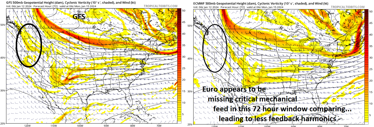
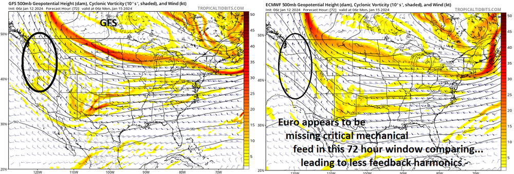
This may also help if interested... I put this in the NY City thread - a bit of an extended evalution/more discrete, regarding the EPO relay of ...whatever is ultimately going to be so - "....the N/stream additional S/W power at mid (500 mb) level 72hours diving S out of western Canada in the GFS that the Euro doesn't have - sort of resembles an 'intermediate jet stream' feature. The GFS phases ... which leads to more power getting relayed E than the Euro, which doesn't perform this phenomenon because it doesn't "see" that middle stream mechanical influence. Here... I just didn't want to get too detailed in the previous post .. but all this is ultimately coming from the complex handling over the EPO domain. What is actually going to get sent down river determines what's tumbling over the dam
-
Is it possible that some of that 'success' interpretation is attributable to increasing integrated PWAT that's objectively measured everywhere. I mean shy of invoking the sensitive climate topic ... part of that CC is the increased WV loading, and it's definitively being registered in deposition rates. Anyway, just wondering if we took system A from 1920 ( say..) and ran it through modeling/reanalysis now, would that same system be more prolific.
-
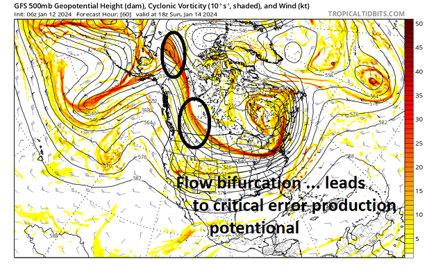
Yeah, it's straight-up a wave addition or not addition taking place between the GFS vs Euro respectively. Not sure why the EPO relay is different - that's what I was after in describing the original bifurcation stuff. There's excruciatingly tedious albeit crucially important differences in what exactly is sent along and ...well, there we go
-
Yeaaah... I'm not gonna say 'unlikely' from this vantage, but ... that feature, albeit important in general, appears to be handled similarly between the GEFs and EPS... It's running out ahead and dematerializing in the compression gauntlet over the SE. (that analysis can and probably should be refined further, however) However, the N/stream additional S/W power at mid (500 mb) level 72hours diving S out of western Canada in the GFS that the Euro doesn't have - sort of resembles an 'intermediate jet stream' feature. The GFS phases ... which leads to more power getting relayed E than the Euro, which doesn't perform this phenomenon because it doesn't "see" that middle stream mechanical influence. Here... I just didn't want to get too detailed in the previous post .. but all this is ultimately coming from the complex handling over the EPO domain. What is actually going to get sent down river determines what's tumbling over the dam
-
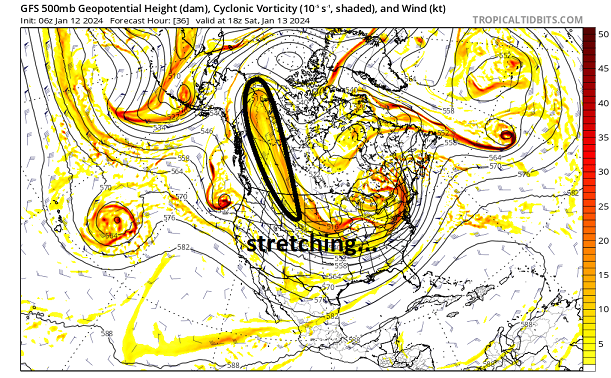
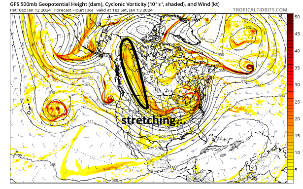
I posted this sequence below ( from the GFS to make the point -) in the NYC thread. I feel fairly confident the majority of sensitivity leading up to this event is coming down to this flow bifurcation phenomenon that is illustrated ... This handling appears to be the source/origin for the S/W in contention - there is likely either errors in sampling relative to either idea ... OR, the physics after the fact is exposing one or the other as having an an issue with ballast - how much recedes vs gets injected downstream ... 1 2 3
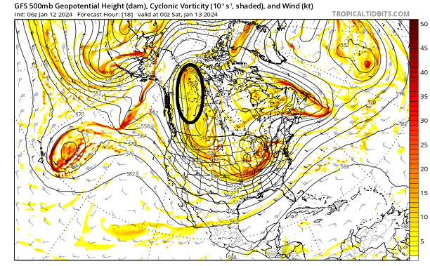
-
This entire handling discrepancy between guidance systems strikes me as data ingest problems. I've posted this over in the NE thread - but the source/orgin for this event is not arriving via canonical Pacific routing but is actually an inject from SPV decay over the NW Terriorties/eastern EPO domain. It's not abundantly clear that is either well sampled, or even natively handled ( physically..) in the guidance given that processing headache ... 1 2 3


-
We should go look at the source/origin of that event's governing mechanics, and see if we can identify any similarities - not even analogs ... but by concept. I mean if data sampling can [possibly] be identified even regardless synoptic scaffolding. Here's a thought: the Euro has this 4-d variable correction/smoothing system that is really why it was "Dr No" for so many years. Letting model physics run naked out in time will result in more boners because their junk flops around a lot more, whereas the Euro "corrects" those by tucking them in a jock-strap that's really purposefully designed to limit fractal from taking over and modulating out in time... Kidding obviously, but the point is ... the Euro may be "over correcting" because "if" it's not getting the proper input, it "assumes" it's errant and removes it. I'm just baffled how there's so little in- between here.
-
Yup ... What just saying the same thing to Seymour' ... I just can't help but think about the Boxing Day event in 2010. That one was on fumes even mere 48 or 60 hours ahead and out of nowhere we were left to trust the NAM ( ETA?) ...which seemed to be the first to pick it back up. But even then it was dubious because the NAM had ( and may still have) a NW bias over the western Atlantic as one of many in it's various idiotic charms. Then the 06z Euro marched back... what? and all the sudden, 12z runs start pouring in big event out of seemingly nowhere. That was an event that had considerable presentation when in the deeper middle range but was lost for 2 or even 3 days...