

Typhoon Tip
-
Posts
44,244 -
Joined
-
Last visited
Content Type
Profiles
Blogs
Forums
American Weather
Media Demo
Store
Gallery
Everything posted by Typhoon Tip
-
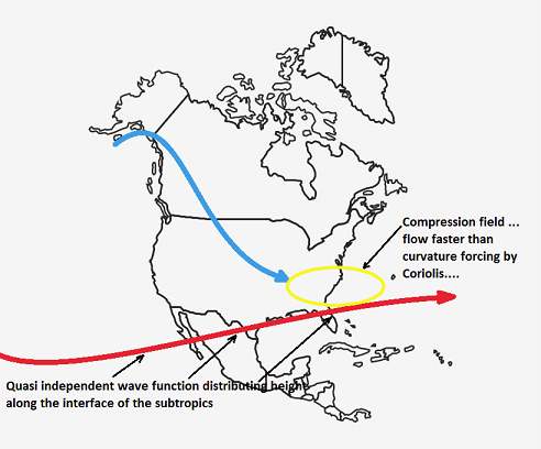
It could. I'm really using thought experimental logic to explain what/were the limitations are. As far as "fixing" this thing? haha. Yeah. I think of this way... the heights over the S-SE seem to roll along by a different wave function/planetary forcing, and may or may not be in sync with what's going on over top ( above say ... 35 N). Here, I can draw a quick and dirty illustration to explain this pictorally This happening at varying scales ...etc, this is just a illustration to bring the point ... If you can imaggine this "Quasi independently" caused height wall in the S to be oriented opposite of that implied wave signature, than there is less compression --> less +d(v) in the flow entering, which then allows more curvature to take place sooner with less shearing... What the flow may actually look like, while the above is happening, doesn't necessarily reflect -
-
See - without even looking at this product, 1978 is in there. I'm tellin you guys - big big dawg is being poked. Not sure we can wake it up in time. With all this speed shearing and forcing this thing to open ... It's offsetting the time it needs to "couple" to the planetary curvature/Coriolis ( that's really what it is...). The dy/dt is the N-->S component velocity of the SPV piece. The dx/dt is the W-->E component of the S/stream S/W. When the ratio of these two are compared to the time constraint of the Coriolis parameter, ...I bet you dimes to donuts that needs to be closer to proportionate for determining phase proficiency. wow
-
Oh, I said that backward... let me fix that. The thermal wind vector increases, the velocity of the geostrophic wind increases, and thus Coriolis parameter can no longer force the flow to curve in time - the centrifugal ( g-force) over comes the curvature imposition of the Coriolis effect. That's what opens the flow - fuck. I correct that. The Coriolis parameter has time in the function... here, I just grabbed this right quick off of Wiki' The rotation rate of the Earth (Ω = 7.2921 × 10⁻⁵ rad/s) can be calculated as 2π / T radians per second, where T is the rotation period of the Earth which is one sidereal day (23 h 56 min 4.1 s).[2] In the midlatitudes, the typical value for f is about 10−4 rad/s. Inertial oscillations on the surface of the Earth have this frequency. These oscillations are the result of the Coriolis effect. anyway, it's simple - lower the god damn gradient so the Coriolis can curve the flow.
-
...I was also noticing that the final bifurcation of the western Canadian quasi SPV feature is actually taking place during today - so there may be a subtle modulation in what is really injected into the flow, being initialized into the grids today.
-
Interesting how persistent the RGEM has been ... And if getting persnickety in that analysis, it's even been adding QPF in small increments, while continuing with the same general synoptic layout of this event. It could not be anymore cut-and-dry case for being proven either right, or wrong. If it verifies even above 80% of its panache, it's going to be an emphatic winner. Anyway, this 12z run... if we just bump it's QPF layout 20 or 30 mi SE, HFD-BED ends up with 6+". It's high end advisory/low end warning snows. It's certainly plausible that the QPF is right and it's too liberal warming the SE of that axis, anyway... I mean this antecedent arctic boundary apparently means business. The NAM is also some 70% of that QPF ... just estimating, while having a similar synoptic evolution. Why for the QPF differences when the synoptics appear otherwise to be the same - some difference in physical make-up? I dunno. I'm leery of the NAM's NW bias at this range. It's interesting, however ...that the RGEM is sort of trying to peer pressure the NAM into taking the same drug. Haha. I'll tell you though.. pure supposition - but maybe these higher resolution models are "understanding" the physical initial conditions better wrt to this newly arriving and intense arctic boundary. It appears to slow down dramatically after arriving here... collocating with the existing thinkness gradient that extends ~ ATL -Va Capes to SE of Cape Cod. That's going be an axis of explosive potential, to understate it.. It would not take very much jet mechanics at all to activate a low pressure along that zone, and given the efficiency sharpness of the frontal/thickness packing, the UVM circuitry will be made more proficient. ... I guess what I'm saying is I can see a valid argument for higher res models doing what they are doing. Technically the Euro qualifies as a high res tool, as well.. which doesn't lend as much help to this idea.
-
I'm wondering if there was modeling error ( from 10 days ago...) wrt the extended range, and what's happening now west of this arctic boundary Quite the impressive morning array of obs expansive throughout the entire continental midriff ...with -20 to -7F, 2-m obs everywhere. I was looking at western Michigan ...everyone is 0F in a WSW wind having come across the entire ~ 50 miles of that Lake Michigan, and -12 on the Wisconsin side ...that's a typical correction from thermal input off the lake that happens in syrupy cold outbreaks. Then, of course hundreds of miles of brick earth negative temperatures throughout the CP/NP regions. That KC/Dolphins game ...ha I get it that it was signaled - more or less... I'm just wondering if this is a rare cold bust for a change, even if by a small margin.
-
Yesterday I was musing about the front edge being a single clap of thunder with a mix of small rain drops and big aggregate snow balls that mimic soft hail, going sideways under a rapidly advancing outflow nimbus belly, soon to flash over to the whiteout snow squall ...ending in 10 minutes. It's like if you went 2/3rds or something up the vertical column of the typical squall line in summer, and brought that region down and made that the bottom of the storm ... sort of -
-
Scott nailed it in his morning/brief analysis, using the Euro to describe primary limiting factors re the 20th system - it's actually consistent as an observation across all guidance, really. It's also been the case since the period in question first began to emerge in the operational versions. ..some 3 or 4 days going back (btw, the 20th was suggested via other means going back long prior to the operational model detection - ), and has persisted ever since. Just want to add some analysis/observations to that. From a broader perspective, the velocity of the field is there first, and is "why" the above factor has persisted. Why? The models have difficulty (perhaps a range -related thing .. I wonder ) constructing N-S orientations - it becomes a geometric problem in that higher velocity, when going around any curvilinear trajectory, induces an outward acceleration force that is normal ( perpendicular ) to the surface at every point around the curve. This acceleration force is centrifugal, or "g-force" as is often referred. As the speed of the movement around the curve increases, the g-force increases with it. How it effects the geometry the atmospheric circulation pattern: When the effect is large, it's because thermal wind vector component of the geostrophic wind equation is very large in higher gradient, and caused higher wind; that forces the curve to open up. One needs to compare equations ( mathematically ) to assist in proving this, but the aforementioned concept matches the observation in the field rather nicely. It's fascinating if one understands this. Annoying and invoking of chiding when they don't. I understand this... buuuut, unfortunately, the fascinating aspect is being on textbook display and is why this isn't already modeled as a 1978 redux. All the players are initially present. In fact, even the super synoptic indicators are flagging something incredible. The idiosyncrasies surrounding the negative interference via too much flow velocity, that is unfortunately not described very well in either the snap shot of identifiable features, nor these numerical teleconnector projections, respectively. 1 The PNA is rising slowly anyway nearing the period, but, all sources 'jolt' the index from ~ -1.0 to +1.0 SD in the 2 days immediately antecedent. That's a big signal from a super synoptic source - check 2 The -NAO corrects to neutral - this is physically expressed on the synoptic charts as the western end of the block collapsing S across the Canadian Shield; underneath this mode change, the 'SPV fragment and cold mid and upper heights are conserved, and threaten to inject an extraordinary instability into #3 (below) - check 3 The rising PNA injects(ed) some sort of intermediate and/or S/stream S/W which interlopes underneath all that in proper timing - a simple way of saying they are in wave harmonic/ or positive interference - check It kind of all smacks as a 'chicken vs egg' conundrum but it really is started because there is too much gradient through the total domain region in question - which for the purposes of this discourse is really from 140 W through 60 W. The flow is faster over the continent, because the continental influence on the total circulation of the hemisphere causes it to draw cold air down, which reinforces said gradient in perpetuity. The models have difficulty ( observational assumption ) in this area with acceleration being variable from run to run, particularly at the 'flop' end of 'the extended range hose times'. That's why I am willing to postulate further that range is related in this error. So... in simpler terms.. .the Pacific is attempting to for once serve us better by sending the +PNA --> +PNAP flex. It's there. Unfortunately...the models are constantly countermanding ... negative interference by said overabundant gradient problem. The flow speeds up... the heights are physically limited from N-S orientation... It's like this idiosyncrasy is competing - and what's interesting is that the models are actually creating both sides of that fight.
-
Hilarious! That gives me a perfect mental picture… “Cars sliding down to Zakim Bridge into the tunnel”
-
He may be subjectively right - if that makes any sense ... If we lay in 3-5" ( say), that's not really a snow "storm". But the other aspect is that it may be up the coast from the mid Atlantic latitudes, either way.. so, partially correct there, too.
-
You know what this reminds me of a bit ? In 2003 ( I think it was...), I was living in Winchester, MA. There was a lakes cutter and southerly warm gale event ... wanna say Dec 2nd or so... then two days later, we had a front go through with some rain and snow showers mixed and it got intermediate colder. Then a day or so later, morning WINDEX squalls strafed with very low visibility and temps crashing from mid or upper 30s into the 20s. About 1-2" is all they laid down, but... I-95 between Danvers and the Bedford curves became 10 miles of stand still gridlock. It became a headline news thing over 1-2" of snow flash freezing... 3 days later the Dec 5-7 event
-
Huge change in the member depiction, too... There's likely some members in there that are more like the 12z still - and are overcoming the speed of the flow
-
oh I don't care who says it first. ha. Anyway, the 18z GEFs just went some 10 to as much as 12 dm deeper with the non-hydrostatic height depth leaving the M/A with the 20th compared to the 12z ... I'd call that a pretty significant adjustment considering the entire synoptic manifold is involved here - the impetus here being the trend
-
ah, you beat me to it, Brian - yup
-
haha... sorry it was an inside comment to Will - he knows. Basically...the physics in the model "sense" that there should a low there - produce one incompletely, is what happening. If this was more proficiently phasing, that would probably be the "real" low, and it would be a much bigger ordeal there. It's good in the sense that it's possible still? But I'm not sure we are going to slow things down enough... the 12z guidance did seem to slow a fraction and almost immediately we saw a better performance.
-
I'ya I'm just gonna tutor y'all 'bout how this subsume shit works. The X coordinate S/W translation speed ( not the same as the wind flowing through the medium - whole 'nother headache), needs to be as close to the same translation speed as the Y coordinate of the severing SPV fragment/N/stream tucking into the back side. Those deltas need to = 1 as closely as possible... Nothing in the atmosphere is ever perfect... but ...get that up 70 .. 80% and you turn a pedestrian system into bombogenesis potential. All you have to do is find the best perceived center mass of the N/stream, and click a couple intervals, and measure the N-->S distance/time ... that equals your dy/dt. Do the same for the S/stream dx/dt, or W-->E. The ratio of these in this case is about 1.5 . that's just too fast in the southern component ... But just looking at the synoptics? yeah, you can see how the SPV/N/stream collapses in but it's chasing and not actually 'catching' the S/W wave space - it escapes east as a shearing stretched out weaker system.
-
We're getting the old placeholder anchor low extending west, though
-
Fwiw - ICON came back and embarrassed some posters - if they're capable of shame sorry just a little agitated more than normal
-
should be a 'scorched earth' policy in effect when people can't control themselves. hard to believe these are 30 40 50 ... 70 year-olds we're talking about but oh well. starting to suspect there's a raw competency limitation that we're far underselling - it's not that people's expectations about storms get too high, it is that we the thread writers and discussions purveyors have too high of expectation in the audience that's in the room - I dunno. some of you just need to shut the fuck up and leave
-
Huh... really does feel like a cool spring vibe out there. Even smells like it ... like a misty day during mud season, circa late March. Just noticed a broken squall line of low toppers forming west of Worcester
-
think you're mistaking me with someone else there. just nailed the one last week from 7 days out - hello.... secondly? i don't care about people's paranoia. lol. seriously I don't. i start threads for interesting periods/event - which in the winter ... just about anything qualifies as better than sitting around waiting in 40 F dim sloped sun over bare earth. i will add this ... there's some memory fabrication going on, most likely. people need to appease this addiction to seeing big blue gpf bombs on illustrated guidance and so, if that doesn't materialize in the guidance after a thread is posted ... there's this associated of that discomfort to the thread poster - which is as ludicrous and unfair as what ya'll do to your selves waiting on d-drip in the first place. i don't ever own any responsibility to that. plus, it is also pretty clear that the content of the thread starters are seldom read with comprehension, because there are often plenty of qualifiers in that should/could be used to temper confidence and or impact expectations.
-
yeah I mean I did set the ceiling on this to be moderate for a reason. At the time ...we're (unfortunate to higher end proficiency) modeling a fast velocity soaked pattern. I asked Will if we should go ahead and switch the title of this thread to include both event - they are sort of indirectly effecting, because the SPV that subsumes in the 20th is in fact part of the suppression of this leading system. Complex -
-
yeah.. agreed. Adding to this 'interest,' the 12z Reginald was a reasonably good continuity from the 06z ...
-
Will I dunno, do you want to just merge this into the 20th? Originally I wanted to keep these separate but the two events are 3 days apart and the temptation is maybe too much to ask ... Both events are in fact nested in the same signal. The con is that they are distinctly different. The 17th is off the boards, and the 20th,... being a subsume phase potential and so forth ( which the 17th bears no likeness to), it's not apples to apples. But maybe for convenience we can change the title to 'monitoring 2 potential impactors in close timing' or something?
-
Yeah... it's not the first time that a mid range cyclone degenerated into an isentropic lift scenario - think of warm advection bursts as the intermediate scaled amplitude between no-go and a well/better formed cyclonic storm. Frankly, I put what we've just witnessed over the last 24 hours of rug pulling as clear model attenuation phenomenon. I suspect I know the cause. I'll repeat here what I wrote to Scott (for commiseration) over in the January thread, because it was in regards to this event ( and the 20th for that matter) "There's too much compression in the heights through the integrated manifold, between 70 N and 35N ... over the eastern continent. The flow is physically speeding up as anything attempts to inject into that region ( you know this - just commiserating here...), and that acceleration is absorbing the native mechanics of any S/W ... If the S/W can't impose it's own forcing in the field, no storm. Instead, we end up with models being dense ( stupid ...) about the speed of the flow and having to then speed it up. They have to destroy their own cyclogen parametric/resulting design, as the mid range torpid flows become realistically bombastic in the nearer terms." Credit the Euro so far for "seeing" attenuation before the GFS. I did mention either very early in this thread, or just prior to starting this thread over in the January one, that 'one way to overcome the Miami rule is to have the embedded S/W be very powerful' - over the last 24 hours that power has attenuated. That's just it. Having said that, I've noticed that some meso models are punching a WAA burst over at least a weak cyclone, closer in from over night and continuing this morning. I don't believe this event or thread is completely baseless at this point in time. Cyclogen coherency ... pehraps decays toward the isentropic type of event. We should also note that the thread title clearly states to ceiling this at moderate - sometimes it helps to really read and learn the 'intent' so we don't dial up our expectations.


