

Typhoon Tip
-
Posts
44,244 -
Joined
-
Last visited
Content Type
Profiles
Blogs
Forums
American Weather
Media Demo
Store
Gallery
Everything posted by Typhoon Tip
-
It strikes me as just missing data. I wouldn't be shocked if any one of these guidance that currently are showing upper-moderate impact...etc etc, offer up a cycle of whiff, too. It's like an either or thing? You know? either the model's got the data = storm. don't get the don't = not storm. Seems less about handling and amounts in this case. That much definitive difference is suspicious one way or the other, though
-
I know you don't ... I'm just broadcast there to the general resenting tone over the subject matter.
-
Yeah, I mean ...I can't see any other cause of/for the stark discrepancy between - this is/are the wholesale guidance machinery of either, pulled almost diametric. The GEFs? That would be neat result if that 964 MB low on Nantucket Island member of the GEFs verified, whilst the D4 EPS was doing this. Or vice versa
-
Not to push my agenda like a shining dick tip but ... I did warn that these ENSOs were suffering some kind of negative interference going back years at this point. I think it's just too big to wrap heads around or something but whatever ... we're seeing it more objectively/coherently in observations et al now, so it is what it is. And yes ...CC has something to do with it - sorry
-
I'm not surprised the 06z EPS, frankly. I suspected it wouldn't be much of a d-drip savior just yet, because of all guidance systems ... the Euro appears to be the least dispersive amongst its members.
-
I really think folks should pay attention to this ... "I think the Euro cluster overall is missing data. I'm noticing that the source/origin for much of this thing's S/W mechanics are not coming from the Pacific typology - they are materializing out of the decay of a small SPV situated over the NW Territories up amid the eastern EPO domain. Look at the ICON behavior - again...not using that model, the point is made. We vary the sampling of where this S/W's guts actually materialize from just 'that' much you get that extraordinary single run-to-run variance of size and amplitude. " It's at least worth it to venture the question over sufficient data sampling over that region. Not that the open expanse of the Pacific oceanic echo chamber is much better ... but this system's sensitively appears almost - from what I am seeing - entirely with the method/how/how-much-so gets injected from that region.
-
...the flip side of which means, the El Nino is not fully coupling the hemisphere
-
Guys ...ha, I get it - but this thread does not intend to cover the 20th.
-
Yeah I got your point - it was an interesting one, actually... I thought the same thing. Sometimes we forget an early model suggestions because it gets lost in daily arguments among other guidance with variations on type ...size, amplitude... everything. Then, get in closer and that early notion returns. I'm not saying we're getting a 965 mb bomb on Martha's Vineyard from this - at least one Euro run about 4 days ago, if anyone's forgotten. But, there are a couple members of the GEFs in that range, in the spread from both 00z and 06z. I think the Euro cluster overall is missing data. I'm noticing that the source/origin for much of this thing's S/W mechanics are not coming from the Pacific typology - they are materializing out of the decay of a small SPV situated over the NW Territories up amid the eastern EPO domain. Look at the ICON behavior - again...not using that model, the point is made. We vary the sampling of where this S/W's guts actually materialize from just 'that' much you get that extraordinary single run-to-run variance of size and amplitude.
-
I'll have to catch up on this thread ( was back on page 3 ) ... but, just that it's peculiar how the EPS backed off slightly and the operational Euro ...completely devoid on this signal, considering that the Euro source/cluster was actually the first guidance to even illustrate this thing back 3 or 4 days ago.. Now, the GGEM, which had zip clue all along has this amped up snow to wet nasty coastal over Worcester. I rather like the 00z GFS, only because of the compromise between the Euro and GGEM. Haven't seen the UKMET. The ICON when from essentially a 95% whiff to something similar to the GGEM between it's 00z and 06z run. Meanwhile, the GEFs have some scary bombs near Martha's Vineyard. The next question is ... what the fuck is going on -
-
I don't know about the 'big boy' heh... but yeah, I added to that post and discussed those Euro runs
-
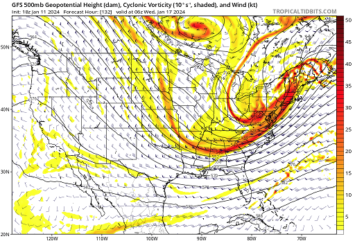
I'll tell you, this is near the ceiling for 500 mb mechanics in a negative tilt. Look at that 150 kts leaving the Del Marva, placing SNE right in the cross-hairs of the left exit region - meanwhile.. .the 300 mb level winds are anomalously strong with hints at entrance region situated over NH/ME Whatever the QPF is on those intervals from HFD to CON you may as well go ahead and assume a meso band or two destroys that estimate. I mean ... this run in a vacuum. I have to tell you though, that is the most powerful S/W ( seems to almost be two in there possibly caught in bed together ) I've seen in quite some time passing over that particular region. 150 f'n kts. That right there is how you overcome the Miami rule - turn the S/W itself into a comet impact. Also, what's interesting here is the lack of S/stream in this lead up. The Euro had more ...but utterly abandoned the N/stream on this last 12z run... It should be Noted that the Euro at one time had a mid 960s mb juggernaut near the Islands... I am thinking about this GFS run ... 'cause, that's what dweebs do. heh. but, if we were to introduce a S/stream (more so) into that sort of junction ... yeeeeeah
-
Not that it means much bur the operational position is on the western limb of that spread - so tfwiw ... it may be easier to ask for it to slip E than to ask all that ens ballast to go toward it
-
You know this.. but we don't sweat it at this range -
-
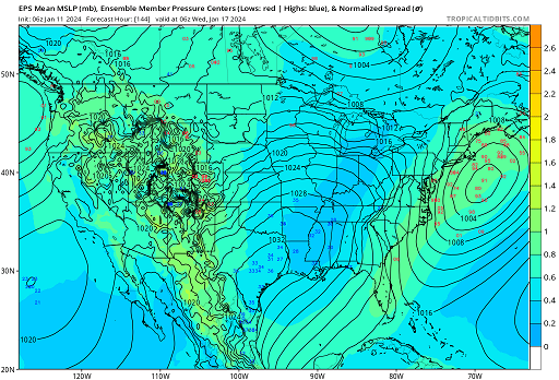
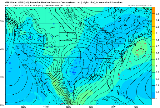
Evolving situation but the signals been in place (actually) for many days using pure numerical telecon spread. +d(PNA) is already underway leading the period in question. Slow rise...combined with the apparent velocity soaking of the local hemisphere may have caused the GFS cluster to rush things (heredity of progressive bias in the product suite?) to the point where it smears the event machinery to where it can't happen in erstwhile model cycles.. However, with improvements in the recent EPS ens mean/with spread noted, now beginning to 'convince' the GEFs (farther below) (...notwithstanding also the impressive operational trends) I feel there's enough to thread this event with confidence for something. It's being placed during a time and space where at least the telecon's have been projecting we're entering a more favorable pattern foot. Speed of the flow is still an issue, tho. Noting the 00z EPS mean and all spread on the western side.. The erstwhile GEFs had been almost entirely absent with this event/time frame ... but rather abruptly on the 12z ( perhaps arguably started on the 6z), we see a coherency with also spread favoring/correction vectoring toward more... There's also a bit more of a conceptual/spatial aspect, where typically a Lakes cutter ( in this case two, interestingly enough...) is often followed by a planetary wave decay-induced -NAO response that drills the successive storm track(s) farther E. So that lends to the general scope of what's going on through this current 2 or 3 weeks synoptic adventure. Noted that there is an off and on signal for 20th/22nd .. this does not cover that period.
-
Yeah been saying this for years actually. It’s not even just anecdotal, either. If we think about H.A.’s statistical approach, which focused on the precipitation distribution/anomalies as they correlate to index mode vs modality ..etc, her conclusions were always that the primary loading pattern is the PNA … The NAO was less correlated. That at minimum argues that blocking down stream is a dubious driver. … NAO -to me - is a wave decay dumpster down stream of the N/A continent interacting with the termination/eastern end of the Pacific R-wave transmission. In other words it’s indicative … not the conductor
-
heh... ah, just so's we're clear. I wasn't intending to forecast that? I was just musing - some sardonic overtones. Most of that was just so that I could arrive to the "climate wokism" - I think that's funny. Non-binary climate is great
-
YES! glad someone else noticed the subsume mechanics going on there. I love that type - I know I mention it often enough but ... it is real and is how/why the top shelf events. There's some subjectivity to that. Like the 18-24" in 7 hour Dec 23 1997 event, which was not forecast like AT ALL... But, we mean the big synoptic history deals. Anyway, it's a long way off but ... the Euro did try to do this yesterday in the range on at least one run, too. It could be we are heading into hemisphere that has some of that tendency in the footprint. However, I see aspect related to too much basal velocity in the flow as neggie factor. interesting
-
Yeah in an isolated observation that was an interesting deepening rate.. It went from like 980 to 960 to 945 mb in 18 hours. RI at TC range.
-
I noticed a big switch in the AO projections after the 20th - particularly coming from the EPS over night. But it's in all three ens systems. It was more evident in the numerical indexes (long lead), but last night's coverage began better synoptic/spatial layout presentation with a distant +AO hat on the hemisphere. Awesome that the SSW paid so many dividends, huh. What's interesting is the cold-gutted PNA spanning the continent underneath that +AO ... Heights across all of N/A below 60 N, above normal, despite a +PNAP curved structure. I grow tired of explaining these warm oddities about that distant range between the extended and model 'emergent horizon' - perhaps attribution -related. I don't have any compunctions about saying that. We could see utter absurd warm passages of time at any point between the end of the month thru spring that are just so obviously 'different' and weird - despite how people will cloak that eeriness in this mantra about 'this has happened before.' Okay. We've seen this too many times, regardless of whatever package of longer termed air-land-sea index was doing whatever. Obviously, a global warming thing when it's (-)(+) ENSO and either way, February's host 75 F bursts. 70-fuckum-5 in February 4 times in the last 7 or 8 years ... while that ocean temps world over are always above normal, and summer time heat-related deaths are the number one killer all over the planet. That is by definition warming globe. But you see.... there's sub classes of denial that have evolved out of the original narrative. It's kind of like the novel virus theory and pathology... how the pandemic agent strikes a civilization and then given time ... it mutates into a lesser virulent forms? These lesser pernicious types out there are in this compromised head space ...admitting it is real, but are not allowed to talk about it. It's almost a "wokism" thing, I identify by non-binary climate beliefs. Just musing...
-
Fast flow is a neg interference.
-
Meanwhile... zip from the 18z GEFs... that's been trending in the EPS though. Little bit of a conflict there huh
-
I found this 12z EPS mean a bit of an eye-pop frankly... It's not only abruptly more coherent as a signal, there's spread toward Jersey containing some real bombs compared to where this was the 12 hours prior. Did anyone mention this ? sorry - piece of shit work day
-
I was in Waltham in 2001. We didn't have the March snow pack at that location - probably owing to the "interior" layout of that year? All I remember is telling Harvey Leonard 5 days before that storm there might be a problem with it being in time because heights over Florida were too high. F'n absolutely nailed it. ...I mean, I certainly wasn't proud of it in that case. We got like 10 or 12" outside my apartment - impressive, but a massive bust compared to the leading week of unrelenting cheer leading PR over Earth's Great Red Spot of a storm. Anyway, I remember a lot of disappointments that year. I think it might have been a gaped bum-hole winter for the coast I'm guessing
-
Some parts to move around but doable at 10 days ( lol ) ... But the tail end of this Euro run is clearly attempting a subsume phase, which are among the most powerful cyclogen mechanism we can find - other than the extraordinarily rare triple stream phases. 1993 March is whopper example of this latter rarity. The Cleveland Super Bomb in Jan 1978 I think was one too. 1978 Feb back here in the E was a two stream but it was on 'roids because it married a weak Miller A response into a Miller B/capture. Kind of a freak Anyway, that much SPV dislodging is interesting. I think the 17th ( or is it 16th now?) is in play but it was likely destined to low/middling system. The phase change of the +d(PNA) is time dependent. It changes -1 SD to +1 over about 10 day span... That's not exactly a huge restoral forcing suggestion when it's that gradual. It's intuitive to think of that as a series of events rather than the big dawg. .. Just thinkin' out loud. That's all predicated on the assumption that current projections don't change ... eek


