

Typhoon Tip
-
Posts
44,244 -
Joined
-
Last visited
Content Type
Profiles
Blogs
Forums
American Weather
Media Demo
Store
Gallery
Everything posted by Typhoon Tip
-
It appears the American models are coalesced ( more than less..) overnight. Everything is on board and pretty well accounted for sounding-wise. This doesn't mean there won't be instra wave tussling in the trough dynamics as this open wave system cuts through, but by and large those "giga" changes won't really ( well ... "shouldn't" - famous last words!) realize much difference to the end results. Looks like a lower ratio snow S of HFD -NW RI to Boston and the N. Shore, with rising ratios pretty quickly in the interior. Some rain for a time in that region, prior to subtle wind backing with deepening low, cannot be ruled out. The region from BDL CT to BED MA could be a jack pot where crossing up QPF with higher ratio/colder profile. Both the 12km and 32km NAM are interesting at a closer analysis of their cinema of the event. After an initial WAA burst of snow there is a relaxation for 6 or so hours ...then Sunday between 12z and 18z there's coherent reinvigoration over the N-W arc of the circulation, along with both a hesitation in the sfc low, and 4 or so additional MB deepening. This appears to coincided with the arrival of the left exit region (provided by 2ndary jet maxim) passing over the vortex and most likely causing an excitation of the ongoing event during that window... I wonder if there is a brief pulse of wind concern coming into the coastal zones, where at that time there may be sticky snow loading and gusts to 40mph/associated CCB genesis upon exit. The global models may or may not illustrate that kind of discrete look as above, but the genera of the synopsis/blend/consensus are not exactly refuting what those higher resolution meso models are doing. I'm curious if the RGEM is doing something similar Sunday morning.
-
I told everyone the next run of this model was likely to go large late last night... I explained why in a small paragraph - I mean with the tsunamis of posts though... Anyway, I feel pretty good about not getting missed at this point. If something like that were to happen it would be a blind-sighted bust
-
Yeah, I don’t know… With a growing consensus heading another direction vs the CMC’s track record … that’s a bit of a buyer’s beware solution
-
It’s putting all that emphasis on the lead short wave, which it holds the identity of longer… It has virtually no interaction with the second wave
-
These differences look largely like noise to me - there could still be a future bigger move or modulation in the system or not, but this is minutia between the 18 Z and 0Z
-
I think the 18Z was a beginning of capitulation … probably related to sampling improvement. Fwiw
-
I want it recorded that these changes became apparent upon the relay into the denser/physically realized sounding grid. My question on that was over assimilation, being as advanced as it is, still has trouble in these longitudinal high-speed flow types… Separate conversation just sayin’
-
Heh if only that ran out to 96 hrs. I mean just for shits and giggles like … that low probably bombs when that 2nd burst of mid level mechanics unzips over top
-
Yeah GFS closing the gap in time in my estimation… But people are gonna rank on it
-
Euro back to king ?
-
East wind initially backs when pressure falls … T crash
-
It's like how the CCB comes in like a fist into coastal towns for 3 hours as this thing's trying to exit on that run. I wouldn't be surprised if this thing gets better on the next cycle(s). As the GFS capitulates to the Euro ideas...eventually it'll it'll bomb a run - not guaranteeing of course... Just that it's been tripping over it's own limitations and now teeters with freedom
-
I got wacked by that a week after thanks giving. Is it a scratchy maddening tickling prickle sensation that sends you into a gag reflex followed be convulsive non-productive vascular headache inducing coughing ? It fades away ... very slowly, after that first 4 or so days of misery with nose and burning eyes to go along with that. Some 4 weeks later I still have distancing tendencies to that irritation.
-
Two Mdt to high impact events NYC subforum; wknd Jan 6-7 Incl OBS, and mid week Jan 9-10 (incl OBS). Total water equiv by 00z/11 general 2", possibly 6" includes snow-ice mainly interior. RVR flood potential increases Jan 10 and beyond. Damaging wind.
Typhoon Tip replied to wdrag's topic in New York City Metro
See reply to Volcanic Winter - same applies.... These are not reasons to raise the goblets here - I'm just outlining that it's not impossible from what I am seeing that this could modulate in favor of clipping your area as we close in on this thing in future runs. So we'll see... I will say that the 90-96 hour run blend translates an intense mid level wind max about 1.5 deg lat/lon S of NYC-Cape Cod. Climo typically results frontogenic (elevated instability) related meso banding through N NJ -CT/RI and Mass. There may be problems with overcoming other synoptic indicators/metrics but there's time. Low probability return for now but there is cast up ability- 3,610 replies
-
- 5
-

-

-
- snow
- heavy rain
- (and 5 more)
-
Two Mdt to high impact events NYC subforum; wknd Jan 6-7 Incl OBS, and mid week Jan 9-10 (incl OBS). Total water equiv by 00z/11 general 2", possibly 6" includes snow-ice mainly interior. RVR flood potential increases Jan 10 and beyond. Damaging wind.
Typhoon Tip replied to wdrag's topic in New York City Metro
thanks! I'm located in a wonderful location here in interior eastern SNE - particularly for this event ( as is handling and extrapolating thus far... ). I don't have any room to complain, frankly -- 3,610 replies
-
- 4
-
-
- snow
- heavy rain
- (and 5 more)
-
Two Mdt to high impact events NYC subforum; wknd Jan 6-7 Incl OBS, and mid week Jan 9-10 (incl OBS). Total water equiv by 00z/11 general 2", possibly 6" includes snow-ice mainly interior. RVR flood potential increases Jan 10 and beyond. Damaging wind.
Typhoon Tip replied to wdrag's topic in New York City Metro
Mm.. so long as we're still (apparently) in a bit of flux as to whence/how much we phase these S/W components that allows some gray area in the probabilities down to central NJ. Pushing it perhaps ...but non-zero. You won't have cold very far away, and if future guidance modulates/interacts these aspect sooner and you implode the column ( cannot be outright ruled out yet) than you could flash over for a time -type of thing... Also, there may be mood by street lamp light activity after the fact in the cooling BLs below the inevitable inversion- 3,610 replies
-
- 8
-
-
-
- snow
- heavy rain
- (and 5 more)
-
Two Mdt to high impact events NYC subforum; wknd Jan 6-7 Incl OBS, and mid week Jan 9-10 (incl OBS). Total water equiv by 00z/11 general 2", possibly 6" includes snow-ice mainly interior. RVR flood potential increases Jan 10 and beyond. Damaging wind.
Typhoon Tip replied to wdrag's topic in New York City Metro
Pretty sure this is the initial step toward capitulation to the Euro, which has been more proficient in that (incrementally) for several cycles. It appears it's capturing more here. Tell you what, if that gets more proficient on the next runs we got a NJ model bomb ( not winking at you per se -) One upshot of GFS volatility is that model has no compunctions over going nuts if given the okay to do so. (tongue in cheek)- 3,610 replies
-
- 4
-
-
- snow
- heavy rain
- (and 5 more)
-
I think this is the initial step toward capitulation to the Euro. It appears it's capturing more. Tell you what, if that gets more proficient on the next run we got an NJ model bomb ( not winking at you per se -)
-
Two Mdt to high impact events NYC subforum; wknd Jan 6-7 Incl OBS, and mid week Jan 9-10 (incl OBS). Total water equiv by 00z/11 general 2", possibly 6" includes snow-ice mainly interior. RVR flood potential increases Jan 10 and beyond. Damaging wind.
Typhoon Tip replied to wdrag's topic in New York City Metro
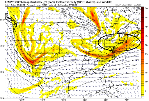
Sure... there are two short waves really in contention for the Jan 7 event. The first is being influenced by the 2nd, further upstream. The 2nd one labeled "2" ...overtakes the lead ( complex physical interaction involving wave mechanics) and eventually subsumes the wave space, which you can see below ... If you go to any of the sites that carry these free graphics and animate the 72 thru 108 hour Euro solution from 12z, you can get a sense of how this happens in fluidity. But ...this 102 hour chart above has captured the surface low that the original "1" triggered, and gives it a goose ( so to speak...) intensifying it further.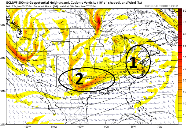
- 3,610 replies
-
- 15
-
-
-
- snow
- heavy rain
- (and 5 more)
-
Two Mdt to high impact events NYC subforum; wknd Jan 6-7 Incl OBS, and mid week Jan 9-10 (incl OBS). Total water equiv by 00z/11 general 2", possibly 6" includes snow-ice mainly interior. RVR flood potential increases Jan 10 and beyond. Damaging wind.
Typhoon Tip replied to wdrag's topic in New York City Metro
Haven't been in this thread - Hey did you notice the double S/W capture scenario going on? The Euro really hits that idea hard, and sends this through a NJ model rapid deepener scenario - toward 985 mb passing SE of the Cape and clear attempt at primitive CCB/clip into eastern southern New England. Fascinating- 3,610 replies
-
- 1
-
-
- snow
- heavy rain
- (and 5 more)
-
know what would would happen... the snow would end around 22z on that ICON solution but then as it gets dark and the cooling BL kicks in we'll start squeezing out teeny flake street lamp snow. And that'll extend up in the column to the inevitable inversion that's left behind ... so it'll last into the evening mood
-
Yeah...that backside trend to extend the pp west with filling in QPF is perhaps a nod to that capture business. I'd pay attention that trend if the ICON is your goto ...can't imagine a mind or scenario where that's actually the case but sufficed it is to say -
-
Just using 'pragmatic imagination' here: the system for the 10th is higher risk for several meteorological impact reasons - perhaps they don't see the need to expend resources for a pedestrian risk in the foreground
-
massive massive scaled DVM chimney implicated over the Siberia to Alaskan sector. I'm wondering if we convert an already robust -EPO signal into rare cross polar flow structure.
-
actually ... interpolation may begin to "sense" of that now. But your right - the 00z is when it starts directly nosing over California
