

Typhoon Tip
-
Posts
44,244 -
Joined
-
Last visited
Content Type
Profiles
Blogs
Forums
American Weather
Media Demo
Store
Gallery
Everything posted by Typhoon Tip
-
It's been an interesting season for model performance ... it's been A, or F. Not a lot of mediocrity there. This handling of this recent event was piss poor in the global runs. I don't consider their ceding to the event with just 30 hours remaining before dandruff as acceptable. Booya to the meso models - particularly the RGEM which took the trophy in performance. Sans details and people just not being happy with the d-drip dosing, probably skewing the fairer judgement for it ..., the essence of getting an event out of the performance window actually seen by technology that is supposed to be able to see it ... the RGEM was miles ahead of the pack. The NAM comes in a second on that...perhaps the ICON 3rd - I do recall some consistency around a 3 or 4" interior result from that particular guidance. Anyway, going back the system that dropped the 6-16" across the interior the week before...the global models were outstanding on that one. The one next week - I prooobably shouldn't be too optimistic about that at this range. It's not really anchored in telecon signaling, and the ens means may be too noisy to handle the delicate nature of that set up. Which leaves it up to the operationals to be right with less support. Eek! But I've seen that type of snow event 'sneak up' on forecasters back in the 1980s and 1990s - prior to present day modeling standards. You get that NW-SE oriented polar boundary and then sustainable isentrophic lift develops over top. What looked like a warm interlude ends up shunted to PA, while we contend with episodic gunky snows and mix. You know,... ( can't believe I'm saying this with Kevin in ear shot) but that could also evolve into an icing scenario.
-
Not only that... the one about day and half after the 24th -ish has also been surprising consistent. Very similar to the predecessor... After all that, we may begin to see the N/A look tilt in favor a low amplitude +PNA, with overriding -EPO loading cold. Higher hopes for that last week of January into the first week of February from my desk.
-
I believe it's legit guys - just my 2 cents.... As I'm sure both of you are aware, this below has been a consistent feature on or around the 24th for many runs... Sometimes more than less actual snow, but the same synoptic cinema. It's now also showing up in the operational Euro more than less. The thing is, this sort of event tends to get buried in the noise of the means so those are less useful at this range. It is also not a telecon signaled type, either. I don't have a problem with it. I posted that episodic confluence across the Canadian shield would threaten the homogenized warmth idea a day or two ago. But, folks get caught up in the neg- head meme thing, so it's not really probably being read very well... ha.
-
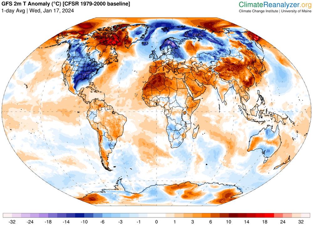
This thread has gotten away from strictly El Niño… That said, I don’t think people should hang their hat on whatever the EPO projections are right now, because they’ve been unusually variable – typically they are more stochastic than the larger domain space/index fields - including the NAO in that part of the discussion. But this year in particular the models are having trouble with continuity with and how much 500 mbar anomalies are really gonna be situated over the Alaskan sector in the average extended. Gee it almost seems like a -PDO battling with an underpinning warm ENSO. . … It’s an important issue for determinism, because we are approaching the climatological nadir. Just so happens to be these models are also trying to make us go above normal on top of that - but that may be changing before our very eyes. I’m noticing that some of the operational dailies are starting to tinker with how much warming there’s actually going to be. I think there’s just enough uncertainty coming from these various arguments to wonder how warm it’s gonna be N of DC these next two weeks
-
It's interesting ...this 'warm up' next week, not prepared to say it's formally in trouble, but ... it does seems we are dealing with episodic confluence/induction of +PP scenarios too often for me to sign off at that being of larger positive departure - speaking to roughly N of PHL latitudes. In fact, ...operational GFS runs are periodically even snowing as warm surges occasionally abut the resulting +PP cold walls and run up and over.. We'll see on those but there's room here to suspect a corrupted thaw.
-
yeah...snark aside, that annotation is in regards to that particular model depiction -
-
Personally not surprised some models may be attempting to north adjusting as we near. Brookline' and I were discussing last night and those synoptic conjectural aspects are still very much in play. There's a ton of powerful jet max running along S of LI. Previous guidance cycles have been suppressed down around 2.5 or 3 Deg lat below the ideal climate signal for White Plains NY to Bedford MA QPF max, but as we discussed ... if future guidance were to wiggle that axis just a hair, 1.5 N - very doable even in good performance modeling sources at an 84+ hour range - than it's too plausible that we're in for another short range correction toward a light if not moderate up to the Pike. Wiggle more ...adjust more...less, adjust less - talking in terms of the probability layout. I think Walter's been posting those over in his thread efforts in the NYC thread; they may or may be based up this sort of climate approach - in fact I'm entirely certain what constitutes those products ... Anyway, I've been noticing with the RGEM too ... both are filling in QPF to N. PA and S. VT/NH whenever the jet axis ticks N across recent run cycles ... which tentatively offers a realization on this philosophy above. Like I've been saying ...I'm not sold on missing a light to potentially moderate result clipping the S. half of the SNE. It's appears the sensitivity is related to where the W-E axis situates in latitude entirely with this.
-
-
It seems pretty clear that's getting more difficult, year after year, anyway. Just hypothetically: suppose in 1950 there is a 50% chance of being above normal snowfall when peering ahead from any given October 15. Now ? -would be perhaps half those chances? 25% ... Certainly it is less, though. At the rate in which CC is occurring already, makes the present 7-10 day scold wave across the CONUS, and any possible winter-storm events connected to it ... seem to be the rarefying state. There's currently an article published over at Phys.org ... quoting among others, Judah Cohen... His contribution is generally on point ... Et al, they describe that the reason N/A is cold is in part because the AO is forced negative by Global Warming. I don't have any issues with that, ...despite some home-grown dissension over the him - I don't really engage in that popular dissent so be that as it may. I don't follow his work. But I will add that it is theoretically sound to connect warm excess terminating into higher latitudes as contributing to increased incidences of higher latitude blocking. Blocking then directs planetary CCB channels into mid latitude, and like water ...finds the pathways of lesser resistance. Which it happens to be that the topographic macro-scaled circumstance of the NE Pacific running into the western N/A continental cordillera, creates a natural channel east of said Continental Divide. So ...in principle... CC can be at least partial in why the U.S. seems to do okay with cold waves while the warming over the integral of the world is actually increasing.. Whenever I read that statement you wrote (bold) in general (seems to be meme in here), the first internal monologue that coalesces out of the white noise of the mind goes something like, "who ever thought that was possible." Obviously, it is possible - sort of. Buuuut, DP/DT (change in possibility over change in time) is not only in decline, year after year, it's likely accelerating in the D' - most objective observations around the world, at minimum make that intuitive. But unless we get one of these CCB channel events to produce big dawgs with more success, it does appear the "maintenance" periods in between bounce back too warm to favor - the seasonal totaling comes in the aggregate. Adding up all the nickle and dimes, over the longer haul, will tend to outweigh the bomb-cyclone trophy totaling. If we lose the nickle and dimers... it gets lower dicey. But ... hell, it may be a fun challenge to try and buck those odds.
-
God it feels good to be a gangsta' !
-
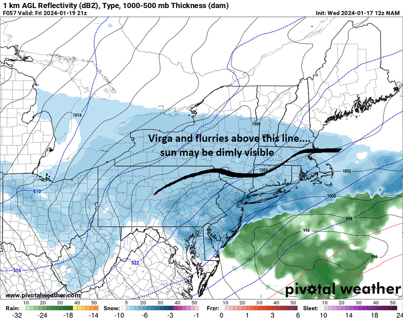
ICON gets steady light snow to CT/RI …moderate PHL-NYC
-
Yeah, I agree… I said something about that several hours ago in a post; so much power in that jet core going under Long Island. It’s really like it’s playing with fire. If that thing just giga moves slightly in the north direction or whatever it could mean the difference between, 5 inches up to Hartford in heartbeat I’ll tell you … models obsessed with stretching out everything from West east the whole thing is pancaked
-
Are folks waiting on a big dawg ? I mean a light to perhaps moderate event for Connecticut, Rhode Island, and New York City… it’s already interesting - to me anyway. It just seems like people aren’t interested unless it’s maximum dosage. Ha ha.seriously though.
-
yah... uh, that thing at the end of the week is unfortunately ( for deterministic efforts) still sensy. The stream/mechanical interaction between the failed subsumption scenario while still S/W wind max potency running under LI could ..."accidentally" snow 4 or 5" down there. If these players are still tussling tomorrow night in the guidance, it may almost be a now cast effort - these global models corrected to a light to moderate impactor here in the interior with this thing today with only 24 hours to spare. Erstwhile clean whiffs - it's an apple to oranges system comparison but just shows what can happen when the flow is complexly sensitive. Something about this 10 day window of the risk assessing has been unusually like that. interesting... Other than that, ...kind of hard to run a warm blast with two SWFE opportunities out there -
-
At least it's something - Jan 16th Snow/Sleet/Ice OBS Thread
Typhoon Tip replied to The 4 Seasons's topic in New England
4.5" is my tentative total. We have moderate pixie dust though... Kicked in when the rad said it all kick out. Under the radar probably the warm layer being stranded and it's now cooling and there's some dust growth near the top of the boundary later. But it's making windshields milky white with the consistency of chalk 20.5" on the season 24F -
At least it's something - Jan 16th Snow/Sleet/Ice OBS Thread
Typhoon Tip replied to The 4 Seasons's topic in New England
Really interested in how/why the Euro and GFS did so poorly with this even even when < 96 hours. -
At least it's something - Jan 16th Snow/Sleet/Ice OBS Thread
Typhoon Tip replied to The 4 Seasons's topic in New England
3", then switched to IP at varying fall rates about an hour and half ago. 25F 19 on the season -
This is one of the reason I don't engage in seasonal forecasting for this social media - or anywhere. I wouldn't bother with "snow forecast" ... I find it to be a bit wishy casty If we wanted to focus instead upon the governing aspects that drive temperature anomaly distribution - that can be more readily and correlative -connectable to pattern tendencies; an area where I feel I personally excel ... but I'm not trying to go there ... Point being, if the temperature forecast were BN and the precipitation ( also more connectable but sans any mention of ptype) is AN. Then "odds are" it snows more so that year than if it were AN and BN for those two basic metrics, respectively. Just say AN, N, or BN for precipiation, and because it is AN(BN) in temperature ...etc, and leave it at that.
-
Can’t get any heavier or it’ll dynamically punch through such a thin layer of warmth along the northwest edge, collapsing back southeast during heavy fall rates – if it gets heavier. It’s really pretty much right at the threshold.
-
Might be the best REG solution I've seen for BDL - ASH ... That looks like a 6.5" 20 mile either side of that line... particularly up toward ASH and beyond
-
Okay, ...lunch-time Quarter Backing the end of the week ordeal. I am not totally sure the following hasn't escaped folks' thought processing, but ... we do not have to have idealized subsume phasing and a bomb in order to get a fun/entertaining event for winter enthusiasts. There are plenty of mechanics in play ... the likes of which would not take a lot of unrealistic rearranging to ignite an event ranging from light ( but steady) to moderate/low end major. None of the events within that envelope of possibilities should be ruled out. 1 Very powerful jet core running 1.5 or so deg S of LI is a huge wintertime climate flag for QPF in SNE/CNE. 2 The other aspect that's puzzling to me is ... the period of time in questions seems to either need to be an all out big bird bomb, or, whiff. I'm not sure when factoring in both 1 ... why we are not seeing at least occasional model depictions for a middling event that encompasses up state NY/S-CNE. Perhaps more a philosophical angle on this thing with this point ... but, we seem to be missing that probability set/result in these modeling projects - in fact, I think I've yet to see a 6-8" ALB-BOS/CON result even once - maybe I missed, but that's been rare to this point, nonetheless. Point number 1 screams for it. So I'm prepared to think we just sans the big dawg prospect - in no small part based upon the limitations I spent time explaining yesterday ... - in lieu of the very real probability that a moderate event will materialize out of that mess.
-
OH, gotcha - different context
-
why I be damned ... the 12z GFS appears to lay in .75" QPF in a frozen column for N ORH CO and S NH... That puts the eastern end of the Rt 2 corridor in a warning event - low end anywho sorry if I'm behind a little -
-
why I be damned ... the 12z GFS appears to lay in .75" QPF in a frozen column for N ORH CO and S NH... That puts the eastern end of the Rt 2 corridor in a warning event - low end anywho ...Oops! wrong thread
-
what do we mean by closed off? I see 3 or 4 pressure contours and going below 999 mb by the time this is passing near the Islands down here. I'm not sure I get that sentiment. I think the storm is intensifying in general after leaving SNE influence - sure. That's typical though. It's really just a typical coastal storm, down the scale. We can quibble over idiosyncrasies that look distracting but I see 12 hours of NE wind at LGA to BOS with .3 to .5 QPF in the column, with as I said, ...closed surface contours. Not every storm is 980 haha. I wish


