Typhoon Tip
-
Posts
44,244 -
Joined
-
Last visited
Content Type
Profiles
Blogs
Forums
American Weather
Media Demo
Store
Gallery
Everything posted by Typhoon Tip
-
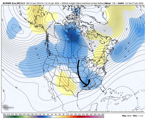
Not to fall back on the principles of 'bundimentalism' or anything but the ICONic solution "looks" a helluva lot more +d(PNA) --> +d(PNAP) than the these other guidance that can't seem to extend the Pacific changes across the continent - for some reason. The latter could turn out correct but just sayn'. In a canonical sense of a (-) to (+) sign flipping PNA ... those tends to lead to more amplitude than not. interesting solution. Also noticing the GEFs mean trying to re-introduce some spread along the NW ... It's threading needle headaches.
-
mm, I suggest the 'hang back' aspect is the most vulnerable to being tamped S-E as a correction, owing to the untimely arrival of the N/stream into this whole thing.
-
It's a good thing I just got done explaining why this has limited amplification space, huh ...well, it can amplify some within itself. What we mean is that the N/stream specifically is a negative interference and won't help in this case.
-
Yes, that is a good description for how this has evolved over the last few days. 'Lowering amplification space' There's a techy reason for it which would glaze eyes over, ...cause a moment of pause before re-engaging in d-drip withdraw syndrome (haha).. but the simplest way to say it: the N/stream is out of phase with this event/S/stream. It's a bit of a race... At this point, if your a snow enthusiast you don't want the N/stream involved, because it's destructively interfering. It's arriving into the wrong aspects of the S/stream wave space; the manifestation of destructive interference is the 'flattening' we're observing. If the N/stream gets any faster in that arrival, we whiff entirely S. So... long of the short, you take your chances on a marginal gunk polar atmosphere that just flips enough - 00z GFS operational best describes that. Then your arctic boundary arrives and suppresses it all away.
-
GEFs modestly improved... Also more spread closer to the Islands. fwiw - I just wonder if the operational GFS has the jitters about venturing the PNA across signs
-
It was a Flop... February 2024 Disco. Thread
Typhoon Tip replied to Prismshine Productions's topic in New England
This is still planet Earth, right ? -
We’ve been Charlie browned by the N/stream plenty enough in the past. … I could see this inching colder until 36 hrs before go time only to have it roar back N with bad handling of the amount of that influence all along
-
Last couple cycles of the GFS have delayed the arrival of colder air compared to prior timing ... That's going to be crucial to ptype in this because the entire system structure is moving into a region that will be early April -like by the time it arrives. As is, there is an eventual transition but it would probably be a too little too late. It seems for winter enthusiasts the sensitivity for what you want succeeding or not is the handling of that +PP loading from the N. Unless we some how cool the column without it ... Otherwise, this may go down as a successful realization of a storm genesis but we're getting shirked - so to speak...
-
Why is that a troll? Not taking sides or trying to be a dick or anything but seriously … that’s a real product, so what’s the issue with it?
-
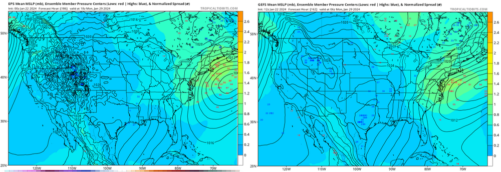
GFS: More than a mere tick N-W with this ... Also .. .156 hours isn't terribly long to start considering things. first of which, noting the +PP N. "Only" 1035, but that isn't a circumstance we've seen very often, if at all ( as far as I'm aware) in several years ... where we headbutt a cyclogen against a +PP N.. two, that is importing untainted polar air. Despite the higher hgts ( 546 dm) the actual lower trop. hydrostats are going to be disproportionately cold. This effects ptype. This is predicated on that orientation being essentially correct.
-
I love it when trough axis start to "scoop" like that... I was talking to prof back in the UML Lab days and I referred to that as 'fish hooking' tends to precede aggressive cyclogenesis. He just sort of said, hm, while slowly nodding. Later that afternoon he was giving a lecture and he said, " ...earlier a Met student referred to this structure as a fish hook" ... I was like yeah. Finally, a moment in college whence I didn't appear to be a complete dipshit - I'm interesting it the interval comparison to the 00z ... I suspect this 12z above is more impressive in this regard/overall just because the consensus continues to improve the contributing/governing mechanics are likely also doing so.
-
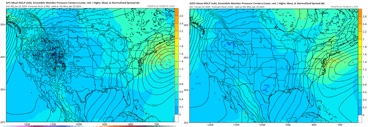
K, so ...if anyone's interested - I started a 'medium confidence' thread regarding the 29th ( ish... lol ) system. Intending it to be almost experimental in the sense that we've see a robust +d(PNA) projected for some time and have been puzzled at how the models et al have shown so little restoring forced system evolution. It appears tentatively as though that is changing, as has emerged with some continuity and generally agreed upon by cross guidance on or around that date. Hence the 'monitoring' thread. Hopefully we can keep it clean? pleasy weezie with sugar on top
-
We'll see on this .. but feel it is at least worth monitoring at this point - if this doesn't happen, it will be an interesting series where a robust d(PNA) sign flip did not result in an identifiable restoring event. ( there may be a need for thread/ Tuesday overnight, particularly along and N of the Pike - this thread is not intended for that coverage ). The backing for this is the (multi-day + multi sourced) index projection loudly signaling system emergence in the OV/TV to MA and New England regions in general, coupled with now both ensemble clusters and their operational runs beginning to finally see a cross-guidance identity in the flow. We had seen a lot of tussling in the dailies ( operational versions ) prior to that, an identity was lost to any corroborative sense, however. A lot of that is probably more acceptable than not, because ... this signal happens to be embedded in the +d(PNA), which for this evolution is a full sign change ( -PNA --> +PNA). That's a bit different than moving the index within the same positive(negative) the standard deviations - flipping the orientation of the mass field entirely is akin asking the operational runs to forecast through an inflection - complex but just inherently error prone. So.. it's actually rather straight forward. This is an emergence of an event that was heavily suggested by prior techniques to actually emerge - and that seems to be taking place now. Note, spread emerging along the NW arc ... This not uncommon for a +PNA emerging event, because the total stress in the field/"correction vector" is actually toward a sooner/west strengthening system, and the models are "beginning to detect" by having ensemble members beginning to pull the result set in that direction... This feels like a scenario where we are on the cusp of coalescing a more important low consensus between the D. Marv/CC-BM climate route.
-
Two schools ... 1 the GGEM/GFS cabal actually has climate on it's side 2 though the Euro does not, ...we live now in an era where climate-based "correctivity" is in trouble; what should not happen, ...still happening, has been increasing in frequency ( huge discussion avoidance here ) Not sure those two facets cancel one another out, leaving us with no clue... Or, we lean in favor of one or the other. I'm personally inclined to believe the GFS/GGEM cabal myself... Because of ... two schools ... 1 our unique geo-physical circumstance is so hugely in favor that even with the burgeoning/disrupted climate signaling taking place, we're still talking atmosphere vs actual Earth (talking about topographical features favoring cold wedging..etc.). Earth should win in that debate. 2 the Euro has been proven fallible vs these other models this year - it's not abundantly clear it should be trusted out of hand.
-
Well then ... looks like the truth's just been dealt an inconvenient narrative, huh -
-
Hopefully this cold was deep enough to set the tick and other invasive insect population back
-
Still waiting on a pattern that really reminds me of El Nino frankly
-
I don’t really think the West specific warm pool is as much of an offset to the El Niños people think anyway.… It’s a full integral of a planet problem. It’s always been about a heat source versus a heat sink. If you fill the sink you have less flow from the source. That is a planetary issue of being too warm everywhere for the El Niño to differentiate against the background tapestry.
-
18z GFS repeats that motif... Impressive +d(PNA) --> zero restoring response-related events, anywhere. Bit unusual ... but then again, we seem to live in an era where unusual sentiment has become usual.
-
Euro repeated the 28th/29th thingy. Fast moving NJ model low of minoring consequence. It seems what's going on with all the operational runs is that they are attempting a transition into a strong +d(PNA) - however transient, notwithstanding - and having nothing happen as a result. Because it's not abundantly clear any system on the 28th is really tied to the former large scale changes, and after that ...there's nothing but an 18 hour cold snap. I guess that's possible too
-
Will's right... the L-current's been weakening and the GOM isn't adjusted in historical climate records accordingly because the weakening has been happening at a faster rate.
-
First it gets warm... then it gets cold, boom
-
Not speaking for Scott here but ... SSTs and "heat content" are too different aspects. SSTs can be affected pretty fast by small time-scaled wind stressing patterns. Heat content more typically refers to the deeper depth/thermalcline integral.
-
Excuse the pun, but I agree 100 % with the bold statement. It's not even just anecdotal. The increasing humidity and rain rates in the MA and coastal New England has already been papered. I'd like to say "talking way off in the future," but given recent accelerations - that can launch a separate debate. But... I almost wonder if a Jurassic climate return would be more sub-tropical ... I don't know about tropical ferns per se... but already, have any of you actually taken a walk through the woods in mid summers as of late. I've noticed them dripping ... rain forest style, when the adjacent field is 88/76 under baking sun - in itself getting harder to believe that DP elevation is just garden DP phenomenon. This is a "more and more" type aspect - not every time. But there are subtle, creeping changes if people pay attention. It seems that could be a natural transition with increasing S-SE, as oppose to the S-SW flow types in summers. That is already been papered - the Bermuda high repositioning farther N is causing wetter inflow tendencies into the Mid Atlantic.
-
I think where Ray was focusing his comment though, was in the facet of needing 'direct cold source'/feed mechanics as an increasing sort prerequisite ... "marginal" events are rarefying. I too have surmised as much in the past. I used to whimsy refer to that as our "flop direction" used to be on the cold side of fence events. Our region seemed to sneak cross a threshold over the last 15 years, an innocuous one, where now we're more cat paws and liquid. etc etc. But from his perspective, if there is a direct cold feed taking place, it tends to be a hygroscopic sink - and he ends up with a moisture deficit that by circumstance happens to consumes fall-rates more so over SE NH into NE MA. That makes just as much plausible sense to me as what you are suggesting - which yeah...I could see warm modulation from the E on average tending to move west, too. But then we'd have to look at CF versus less obvious CF events, versus the former. It'd be complex and nuanced; there could concurrency going on, too.