

Typhoon Tip
-
Posts
43,383 -
Joined
-
Last visited
Content Type
Profiles
Blogs
Forums
American Weather
Media Demo
Store
Gallery
Everything posted by Typhoon Tip
-
For the Mets ... noting the 200 and 300 mb jet overlays, with the arrival of the 500 mb max - that should be a favorable region for mid level forcing - it may be why we are seeing at least light QPF layout extending so far NW into eastern upstate NY and VT, but that could also be an indication of some sneaky banding with higher returns occurring down here where the right exit region of the 500 mb is arriving underneath those upper air difluence channeling. The 300 mb wind is 175kts in the Euro and GFS ( now that they've put down the glue ... we can check their fields!)
-
Heh, not that anything I say is worth a shit or should be heeded therein ... but, I did write it clearly in the title to cap this thing at moderate, also intimating that the impact is unknown - I didn't see enough consistency ( to be honest ) "7-10 days ago" that made 10" confident enough for a ceiling that high. I guess there's some interpretation/subjectivity as to what is low, moderate, vs major. When I was but a Meteorological pupa, 4-6" was considered a low event, followed by 6-10", followed by 10+" respectively. I guess I could be more clear about that range in the future... But 7-10 days ago, this only had a medium suggestion in the numerical telecons ... So, we were - or I was ... - in wait of the operational runs to begin materializing what the numerical suggested should be there - so ... we got some "sporadic" runs with that emergence. I was seeing poor continuity, as implied by sporadic, though. Also, with the speed of the flow tending to stretch/shear events et al - not sure where those concepts meant 8-14" ( major) and a higher ceiling would be warranted - ...
-
This thing has a huge upside to it. But like Four seasons and I were just discussing it kind of lacks the mid and upper level mechanics to get to that top shelf. But the upshot is there, because there is so much explosive potential along/just off eastern seaboard; it really is incredible how much potential is there but not being tapped. Evidenced by spinning up a low end moderate event out of weak triggers - I mean there is some jet going on. But the indexes flagged this for a reason so here we are. Fascinating
-
Yaha it was my phone … almost opted to leave it in there
-
Yeah, I was looking at that… What’s funny about that, even though it came northwest it was still a decent hit before relative to what’s on the table…
-
I think part of the problem is that the majority this event is being driven by low level instability along that very intense bclinic axis. Remember we’re dropping in an arctic air mass/boundary and it’s gonna stall in that area …there’s a lot of Explosive potential there. The problem is is that the global models probably don’t have the lower level resolution while waiting on upper level mechanics … Doesn’t explain why being closer to it in time suddenly makes that all visible but… We’ve seen this in the past where mesos score around these intense gradients.
-
Yeah, it’s making a 3 to 5 inch event more likely
-
GFS looks like the NAM
-
It’s not really east… it’s tracking along the climate route if you look at the center of that mass - it’s really just that it’s weak and spread out therefore
-
Haha. Didn’t we just getting a regional wide 6 to 14 inch snowstorm last week.
-
Yeah... I was even going to say that the "N. Hemisphere" has predicatively superior regions over others - and that individual models will handle quadratures differently than others. In other words, the GGEM may be fan-fuckum-tastic from Japan to California and better than the GFS; the opposite could be true over N/A. (that's plausible speculation though - I don't know if there is any way in which these averages are smoothed, or not smoothed/normalized)
-
I'd say the "voodoo range" - statistically - begins around D10, actually ... but in principle, I don't disagree that there's a futility inherent to being very precisely deterministic ( to put it amusingly ..haha) when it comes to a 252 hour time range. But there are techniques - some are better at it than others ... - that give the D6-10 range a bit of an edge over N/S ( no skill). Having said that... fast whip lash flow tendencies because the same speed, makes it almost physically impossible to anchor a pattern in position
-
People will tend to trust their own anecdotal experience and dismiss a panned statement like this intones, without you citing sources just fyi -
-
I wonder how it will look after this ... For the record ...I suspect this 18z run is kind of bonkers overall - no trolling intended. I think we are headed for a reload interlude of yet unknown amplitude - but either way, I'm not sure we're sending 582 dm heights to the Del Marva to get that done. We'll see... But just J. H. Christ here. This also hearkens to what I've been saying ( for years really - ) that when the cold air shuts off we seem to almost spring loaded bounce into this outre warm plush across the mid latitudes - or tend to do so. It's been so reproducible over the last 10 years, regardless of whatever discrete or voodoo combination of indexes were doing corrections to unicorns, that I begin to think massive oscillatory behavior is the new norm.
-
As opposed to what, though? Not being a jerk just seriously, the options are missed super phase but miasma of snow in the air ( perhaps to moderate), or whiff. I mean we've seen either of those two impact portraits regardless of 12z or 18z or 00z or 06z, over the past 3 days... The only common denominator between all the runs has been velocity of the flow exceeding the phase rate. So that latter can't happen in time. I see this run .. yup, same schtick. There's plenty of time to manifest higher heights over western N/A ...so's we can slow down the flow and allow the dynamic interplay of these features back E, but... supposition: I also suspect some of the velocity issues are everywhere. The hemisphere is just having trouble shortening the Rossby wave lengths overall - in other words, longer ... not taller wave lengths are accessible.
-
Confirm intense squall in Ayer. Vis down to ~150' Est 50 mph wind gust (max). 37 to 27 in a matter of moments lightning up... duration was 7 or so minutes
-
Report: Another Year of Record Heat for the Oceans
Typhoon Tip replied to donsutherland1's topic in Climate Change
https://phys.org/news/2024-01-global-ocean-temperatures.html -
not saying either way ... just pointing out some aspects I'm noticing - Extending that it's hard to automatically assume the lesser popular/known guidance types will be typically wrong in this seemingly rare case.
-
This may be a rare scenario ( when speaking in terms of model performance/history <-- relative to...) that the Euro corrects toward the less conventional/trusted model sources. In fact, ...so rare, I wonder if that's ever really happened where a GGEM/RGEM/ICON blend successfully coup'ed That said ... after 3 consecutive cycles the GGEM had ticked more impacting... as of 12z, arrived looking more RGEM like than ever. It gets hard to knock such strident continuity; now < 60 hours, when said trend of the Can cluster has been there since late middle range. -when then also introducing the philosophical aspect I outlined regarding the explosive baroclinic boundary condition laid into place between ~ ATL to just SE of Cape Cod by this arctic boundary/air mass that slows down and stall along that axis... I think there is too much argument in favor of these guidance from both an operational technique, to concept Meteorology, to dispose these solutions in lieu of a Euro paltriness that has in fact been 'trying to avoid admitting it's wrong by hedging the event in silent intervals' I mean I'm not sure of any of this... sort of tongue in cheek.
-
LOL sorry guys. slow Sunday ... I need it, anyway. fun stuff over fixing legacy code all week - ugh.
-
Not saying it won't - ...just as is, the models that show this 'not in time' aspect are likely suffering from the discussion points at hand. But these are virtual projections. The models may be handling the flow over the continent wrong, too - so they could be too fast. there's moving parts to this..
-
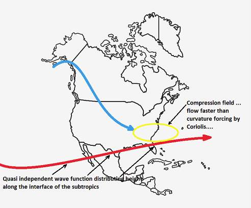
It could. I'm really using thought experimental logic to explain what/were the limitations are. As far as "fixing" this thing? haha. Yeah. I think of this way... the heights over the S-SE seem to roll along by a different wave function/planetary forcing, and may or may not be in sync with what's going on over top ( above say ... 35 N). Here, I can draw a quick and dirty illustration to explain this pictorally This happening at varying scales ...etc, this is just a illustration to bring the point ... If you can imaggine this "Quasi independently" caused height wall in the S to be oriented opposite of that implied wave signature, than there is less compression --> less +d(v) in the flow entering, which then allows more curvature to take place sooner with less shearing... What the flow may actually look like, while the above is happening, doesn't necessarily reflect -
-
See - without even looking at this product, 1978 is in there. I'm tellin you guys - big big dawg is being poked. Not sure we can wake it up in time. With all this speed shearing and forcing this thing to open ... It's offsetting the time it needs to "couple" to the planetary curvature/Coriolis ( that's really what it is...). The dy/dt is the N-->S component velocity of the SPV piece. The dx/dt is the W-->E component of the S/stream S/W. When the ratio of these two are compared to the time constraint of the Coriolis parameter, ...I bet you dimes to donuts that needs to be closer to proportionate for determining phase proficiency. wow
-
Oh, I said that backward... let me fix that. The thermal wind vector increases, the velocity of the geostrophic wind increases, and thus Coriolis parameter can no longer force the flow to curve in time - the centrifugal ( g-force) over comes the curvature imposition of the Coriolis effect. That's what opens the flow - fuck. I correct that. The Coriolis parameter has time in the function... here, I just grabbed this right quick off of Wiki' The rotation rate of the Earth (Ω = 7.2921 × 10⁻⁵ rad/s) can be calculated as 2π / T radians per second, where T is the rotation period of the Earth which is one sidereal day (23 h 56 min 4.1 s).[2] In the midlatitudes, the typical value for f is about 10−4 rad/s. Inertial oscillations on the surface of the Earth have this frequency. These oscillations are the result of the Coriolis effect. anyway, it's simple - lower the god damn gradient so the Coriolis can curve the flow.
-
...I was also noticing that the final bifurcation of the western Canadian quasi SPV feature is actually taking place during today - so there may be a subtle modulation in what is really injected into the flow, being initialized into the grids today.


