

Typhoon Tip
-
Posts
44,568 -
Joined
-
Last visited
Content Type
Profiles
Blogs
Forums
American Weather
Media Demo
Store
Gallery
Everything posted by Typhoon Tip
-
Our fields are fine... Still with verdant green. In fact, Devens field - where there's ongoing Field Hockey and Soccer tournaments - is still uniform green across the 1/3 mile expanse. Granted it won't last ... and getting rain in timely dosing would also help longevity. But over the years, quite consistent with seasonality the fields and lawns will all but inevitably become stressed - some years less than others, earlier or later, but figure by mid summer as an average. Which we are only 30 days from as the Met crow flies, anyway. I realize there's no super cells, or blinding heat, or what-have-you loading syringes of dystopian dopa for your excitement addiction requirements, but tough. Sometimes you just have to endure nice days. Holy shit -
-
Some form of a severe threat, or just some weird anachronistic cyclone for this time of year with a lot of wind Thursday Emerging yet still vague heat signal after the 25th
-
89/56
-
2026-2027 Super El Nino
Typhoon Tip replied to Stormchaserchuck1's topic in Weather Forecasting and Discussion
Oh, I think I know what he meant - it just wasn’t at first clear he meant the 3 SD itself -
2026-2027 Super El Nino
Typhoon Tip replied to Stormchaserchuck1's topic in Weather Forecasting and Discussion
except for those two peaks that are higher -
I'm kinda bustin balls. Truth be told, not sure what the convective temp/sequencing is. We may just need another hour of heating, which can happen at this time of year until 5:30 really. I tell you what, on a separate note high heat a day after severe convection anywhere around here is definitely a Gretta effect -
-
boring and hot nothingness chasing ? ooh, make sure to get some videos
-
Again ... Brian's sarcasm is well placed and probably needed as a dose of reality, but I contend that the image of the pattern as a skewing force. The constant bombardment of model engagement is tinting perceptions perhaps. As I've been pointing out, there's a bit of a disconnect that's been evolving over particularly the last 20 years, where the pattern and the temperature results seem unmatched. Take next week on the GFSX machine. All SNE sites, BDL-MHT, are between 81 and 84. That's climo resulting from a pattern that looks below normal. Add to that, as we get out to D3..4, those numbers get increasingly weighted by climatology, so... any 84 next Thursday could very well actually be upper 80s... Now we're talking above normal in a below normal looking pattern. But people are only remembering the pattern at the end of the months. This is how perception divorces reality - or at least one way in which the observer is kind of manipulated.
-
Yeah, I hear ya. Fact of the matter is...we also have not yet to experienced a synergistic/resonant feed-back heat scenario in this region of continent. They're actually studied in climate as "synergistic heat waves" world over. I may be that we can't. We might just have too many goephysical traits that make that less able to happen here, but like western Europe and Australia, the steppe of the Urals and over in Russia ... Chinese Asia... The Pacific NW in 2020 is an example of that, where carried on for 10 days at some 35+ for high temps.
-
Yeah, we did that in March of 2012 pretty sure
-
el dependent? KBTV GFSX MOS GUIDANCE 6/12/2026 1200 UTC FHR 24 36| 48 60| 72 84| 96 108|120 132|144 156|168 180|192 SAT 13| SUN 14| MON 15| TUE 16| WED 17| THU 18| FRI 19|SAT CLIMO N/X 64 86| 63 85| 58 75| 55 75| 55 83| 63 77| 60 75| 56 55 76 TMP 71 79| 71 77| 62 69| 61 69| 63 76| 68 71| 64 69| 61 DPT 56 52| 57 60| 51 46| 48 46| 51 53| 58 57| 54 50| 51 CLD CL PC| PC OV| OV OV| PC PC| PC PC| OV OV| OV PC| PC WND 10 10| 11 13| 10 8| 9 10| 9 18| 19 19| 18 13| 10 P12 13 6| 20 74| 55 9| 25 20| 23 25| 39 61| 44 31| 24 32 31 P24 13| 85| 57| 30| 37| 78| 51| 48 Q12 0 0| 0 3| 1 0| 0 0| 0 0| 1 5| | Q24 0| 3| 1| 0| 0| 4| | T12 2 6| 12 37| 19 3| 7 8| 7 9| 17 19| 17 14| 10 T24 | 12 | 44 | 7 | 8 | 20 | 24 | 16
-
Indeed... old Sol is doing a decent job at eroding the grunge. Gone partly sunny here and the higher res vis imagery suggests we'll see more sun going forward. Temps 'll likely respond
-
DP's may be growing ( and they are in fact... no "may be" about it) in the longer term average/mean, but they seem to not coincide ( necessarily) when the kinetic temperature is very large - as well. That's probably the sticking point in perception. Particularly true around here. We don't seem to couple say... 76 dp, with 98 nearly as frequently as the same latitude out over N IA/IL for example. It's not like our sun is weaker. There's some sort of geo-physical feedback here that gets in the way of that. Like the baseline PNAP ( Perennial North American Pattern, which refers to the the rest state) affixes a non-linear component of forcing that is ( as "non-linearity" implies) not really very discerned on a daily weather chart but is always lurking, and does manifest in subtle ways. Such as, ...our highest heat ends up coming over top, where it then has to come d-slope. That's just one possible way in which our region hides the biggest DP days from coinciding from the bigger kinetic delivery days. Another possibility ... because we are the continental anus of just about every circulation mode there is with the exception of the EC paralleling "Bahama Blue" pattern ( rarer), that means we have the entire 2,500 miles of accumulated organic and inorganic ( man-made) particulate aspects that can inhibit a purer solar radiation transfer. All these aspect make any linear interpretation of climate kind of fragile when considering things at a deeper level.
-
We're teeing off at 7:30 tomorrow morning. Not a big fan of Saturday morning early anything frankly ... buuut, fairways under sun you could swear you can hear sizzling makes even 82 F a bad golfing experience.
-
Agreed. I'm stopping short of asking that myself, tho, just because there's too much subjectivity to what summer "should be" to really wanna even engage in that futile endeavor, but personally? I think next week is 'seasonally bn' - for older schoolers, they know that means that yeah ... below normal but within seasonal reasonability so nothing obnoxious. The thing is, it's like there's multiple aspects concurrently true. The pattern verifies as a below normal +PNAP structure more than less, but we end up warmer than the pattern suggests we should - while still being lower that summers have been on sunny days going back 20 years worth of Gretta's ovulation cycles.
-
Oh I'm sure it's in the mail. Probably what happens is you'll get that population overtaxing and die off around your region over the next month. Things get better into July while we "wake" up down here. Just delayed. There's always at least 2 or 3 week window where if seems like we left open all the windows, just a matter of when.
-
Ah,... yeah, I guess. I typically just use temperature. DP around here - for me - is always iffy. Seems odd maybe to think that with an actual ocean sitting there, but we are at a non-fixed confluence of a dry vs wet streams. It seems we spend about equal time either in a continental arid Canadian delivery ( even over the top heat is sometimes coughing dry), or... we get a mash up of Dallas to Chicago industrial flatulence mixed with southern bio-mist. Every once in a rare while we'll get a real pure DP air via the Bahama transport - some of the bluest sky on the planet actually occurs when the DP is 78 F that way. Anyway, that split between massive DP sweats to then huge DP sweeps, probably on average ever 2 or 3 days doesn't fix my nostalgia either way. It also seems era bias too. I swear we had more dewy summers back in the 1980s. That's when I moved to Rockport Ma/Cape Ann's arty culture's bizarre marriage with lobster merchants pushing wakes across the harbor by their two stroke diesel engines leaving a trail of black smoke ... I guess the artist paint how the lobster men feed them. Weird cultural shock that year. Sometime later in the 1990s we started getting hotter and drier summers, excluding any outliers like that 2000 oddity. The last 25 years have been variable but undeniably warming across that total variability. But one peculiar behavior I've noticed: a tendency to split the warm heights and warm thickness ( non-hydrostatic height vs hydrostatic height). I keep seeing in summer where the non hydrostatic heights might balloon to 585+ clear to Montreal, yet the 572 dm hydrostatic thickness along with higher DPs curves/dives S of here. Not this week of course. ha
-
Last night I did a 5 minute post dinner stroll to try and get ahead of insulin resistance ... and that was about 15 min after sunset in the still warm/sultry evening air. I came to halt and stood their in the dead quite and did not hear one ear whir, and did not feel a single insect land on the legs. I don't know what's going on... we don't seem to have any squiter's down this way.
-
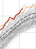
Supposed to be 90 tomorrow and Sun on the same MOS I just impugned haha. Hey, it is what it is. If that's the case, you probably have until that front comes through overnight into Monday morning. Next week looks like a "seasonally BNer" - ie, not ridic just cooler than it should be for the fact that this is going on at the same time... (the brown line is the world ... buckin' for warmest ever against 2024 and 2023 as we speak) Sometimes I think SE Can/NE U.S. are not part of Earth Anyway, despite that weird intention by Gaia to bull's eye New England for enabling deniers, if not hiding CC from Washington D.C. policy makers altogether, ... the actual thickness in that pattern are not appreciably cold. Clears out with WNW breeze in 558 dm -type thickness and it's upper 70s. So there's a sneaky sort of aspect in that, too -
-
Okay ... heh I don't think this is the fault of the numerical models. All of them, including the NAM ... had 700 and 500 mb substantive RH pollution through mid afternoon today. Yet, the MOS (MET and MAV) guidance have "SC", which stands for scattered ( significant solar rad penetration inferred), with temperatures going birzirk to the mid 90s. At least for present hour, it's a reasonable explanation for the discrepancy. The interpretive algorithms ( MOS) are thus somehow statistically offsetting the objective guidance, which would be an error to do so in this case. The cynical explanation because I hate everybody ... this is a nice and tidy example of how you manufacture a bust... You get a "lazified" Met society, getting too used to slouch AI and tech in general to do their jobs for them, and in their reliance there is thus a lack of applied Meteorology to the data. A piece of shit work ethic that gets exposed when the these coffee break solutions in turn fuck up. Ha. I dunno... maybe the forecast gets saved by the bell so to speak if this grunge some how suddenly uncaps the sky.
-
Should this ceiling contamination go on much longer we're looking at a significant temperature bust today - I'm sure Ineedacoldbullshitfilterlikeanalcoholicneedsaclinic will stamp a 100% emoji on this ... but CT also just cleared out rather abruptly over the last hour. Interesting, considering they were wet down there last evening - but this material is mid level so probably not related to that same murk. Either way, temperature can't really rise unless the clearing down there expands. We'll see. We'll rise fast if that happens, but already we're behind yesterday despite the higher launch pad.
-
Epicosity between Northern Illinois and Southern Michigan One contiguous line of tornado and or severe thunderstorm warnings from Grand Rapids Michigan to Springfield, Illinois, actually all the way down to Texas
-
actually these don't appear that impressive. there's not much shear organization. More pulse variety.
-
Cheshire Village area down there
-
True ...I haven't heard any news breaking out of that area tho so it might not have resulted as awesome as that scabby bowed radar looked. These rad products...I swear they're getting goosed for marketing click bate. That thing's rad Rembrandt looked like an atmospheric tsunamis of hail, rain ... leaves and roofing shingles on the leading edge of a-bomb p-wave.


