Kevin Reilly
-
Posts
3,395 -
Joined
-
Last visited
Content Type
Profiles
Blogs
Forums
American Weather
Media Demo
Store
Gallery
Everything posted by Kevin Reilly
-
GOES-East - Sector view: Gulf of Mexico - Sandwich - NOAA / NESDIS / STAR This strengthening rapidly wow!!! Also definitely moving NE too this will be a Cat 4 storm at landfall.
-
Yes, a prolific surge producer on the Southeast side and east side all the way to the coast in some cases pretty devastating.
-
Any idea of the water temp it is currently over. I know last night at this time looked about 88f down SE of Cozumel Mexico.
-
However, currently there is dry air wrapping around the west and southwest side as we speak. Helene will remain in check for now until that dry air mixes out.
-
Totally agree eastern Georgia and southeastern and southern South Carolina with the obvious Florida Panhandle is ground zero.
-
When Helene makes landfall Florida in the eastern Panhandle this thing is coming right up towards Macon Ga. and then slow down due to the capture and blocking present it will be a disaster Florida Panhandle through all of the Southeastern States namely Georgia, South Carolina, southern North Carolina, and eastern and central Tennessee thanks to the blocking. I mean 967 mb just north of Macon Ga. is a disaster especially for Savannah, Hilton Head Island all places Atlanta points south and east since those areas will be in the southeast quadrant especially towards the coast and the I-95 corridor there. Record Rainfall coming and probably winds gusting past 80 mph for certain. This storm merges combines with an upper level low and also is blocked from coming north and northeast with a very strong pressure gradient! Helene will not just be an at the coast event. Helene will remain a powerful mid latitude low all the way to eastern Tennessee. The Southeast is in Trouble with this one! Batten down the hatches and get ready!
-
Currently 66f humidity 96% dewpoint 65f picked up 0.10" of rain today. Crazy stat here: We have picked up 0.18" since August 16th. So..... How are we feeling about the -2.7 NAO???? The blocking is off the chart!!!! Helene will give us zippo. Not many talking about this but when Helene makes landfall down in Florida this thing is coming to a grinding halt first and quite frankly it will be a disaster Florida Panhandle through all of the Southeastern States namely Georgia, South Carolina, southern North Carolina, and eastern and central Tennessee thanks to the blocking. I mean 967 mb just north of Macon Ga. is a disaster especially for Savannah, Hilton Head Island all places Atlanta points south and east. Record Rainfall coming and probably winds gusting past 80 mph for certain. This storm merges combines with an upper level low and also is blocked from coming north and northeast with a very strong pressure gradient! Helene will not just be an at the coast event. Helene will remain a powerful mid latitude low all the way to eastern Tennessee. The Southeast is in Trouble with this one!
-
Welp up here in the Mid-Atlantic zippo has come this way due to blocking. So, my pick is move it north weaken as she goes and the system splits some goes west some goes east as it hits the latitude of say Roanoke Va to Richmond Va. I mean WOW the NAO is sitting at a -2.7 or so that really low and because of it we have drought conditions up here in SE PA. Here in Media Delaware County, we have picked up .10 since August 15th. So, Helene will NOT be coming here!
-
Yea that dry air over the Yucatan and NW of the Yucatan could keep this thing in check for now. Also looks like a bit of shear coming across the bay of Campeche heading east bound.
-
I am going with 5 AM advisory 75-85 mph
-
currently 72f humidity 72% Dewpoint 65 High today 79 Low 65 Total Rain Today: 0.08" Springton Reservoir dropping fast!
-
This is the ultimate blocking pattern!!! I mean nothing can come from the south or west NOTHING!!! Our flow is coming from miles and miles off to our east-northeast from the Central and Northern Atlantic. Meanwhile the flow is SCREAMING across Florida! Looks like a moderate El Nino pattern to me! Thoughts???
- 1,105 replies
-
- 1
-

-
- tropics
- heavy rainfall
- (and 5 more)
-

Potential Tropical Cyclone Eight—50mph/1006mb
Kevin Reilly replied to WxWatcher007's topic in Tropical Headquarters
Models are confused of what to do is it 1 or 2 we are tracking??? Which area consolidates and develops? These are questions I have. Maybe both just fight and compete and don’t develop at all??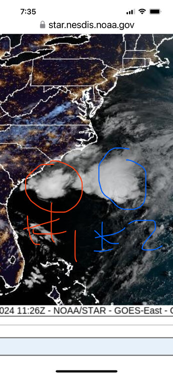
-
Potential Tropical Cyclone Eight—50mph/1006mb
Kevin Reilly replied to WxWatcher007's topic in Tropical Headquarters
Looking at overall wind shear vectors dry air around and strong high pressure to the NNE of this system it appears more of a subtropical storm then purely tropical but still would have potential impacts for sure. Not what the vulnerable Carolina Coast needs. -
Direct Hit from Tropical Storm Wednesday 5 am I’m all in!!! Bring on the rain!!! What can go wrong!!

-
Dry dry dry here it’s incredible all rain is blocked from here until September 23rd if you’re following the gfs. I’ve never seen anything like it or should say haven’t seen a pattern quite like this in a LONG time.
- 1,105 replies
-
- 1
-
-
- tropics
- heavy rainfall
- (and 5 more)
-
2024 Atlantic Hurricane Season
Kevin Reilly replied to Stormchaserchuck1's topic in Tropical Headquarters
Hour 330 yea it's happening!!! I thought the 965 into Cape Hatteras then to Central PA 967 mb was pretty tuff too. -
Actually 1999, I think. It was super dry and along came Floyd on September 17th, 1999, and dropped 10-17" of rain lots of flooding. Floyd came up from North Carolina and passed right along the Jersey shore 40 mph Tropical Storm as the cold front slowly pressed in from the west. We had a pre-event then Floyd then the cold front squeezed everything out. The front crossed through with 40 mph winds as Floyd swept by moving NNE.
-
Nadda really here sprinkles with 40 mph wind gusts and temps have dropped from 77f to 67f It's pretty bad here in regard to the dryness. Rain Total: Trace
- 1,105 replies
-
- 2
-
-
- tropics
- heavy rainfall
- (and 5 more)
-
2024 Atlantic Hurricane Season
Kevin Reilly replied to Stormchaserchuck1's topic in Tropical Headquarters
To me this is just the forecasters covering themselves after saying the season was going to be Very Active!! These systems running around are small disorganized sheared out systems with lots of dry air lurking to be humbly honest. They are however rain makers if they make landfall I would suppose. This pattern looks El Nino like to me as well. -
2024 Atlantic Hurricane Season
Kevin Reilly replied to Stormchaserchuck1's topic in Tropical Headquarters
Oh it will December to March Mid Atlantic and Northeast winter season is going to be historic!! -
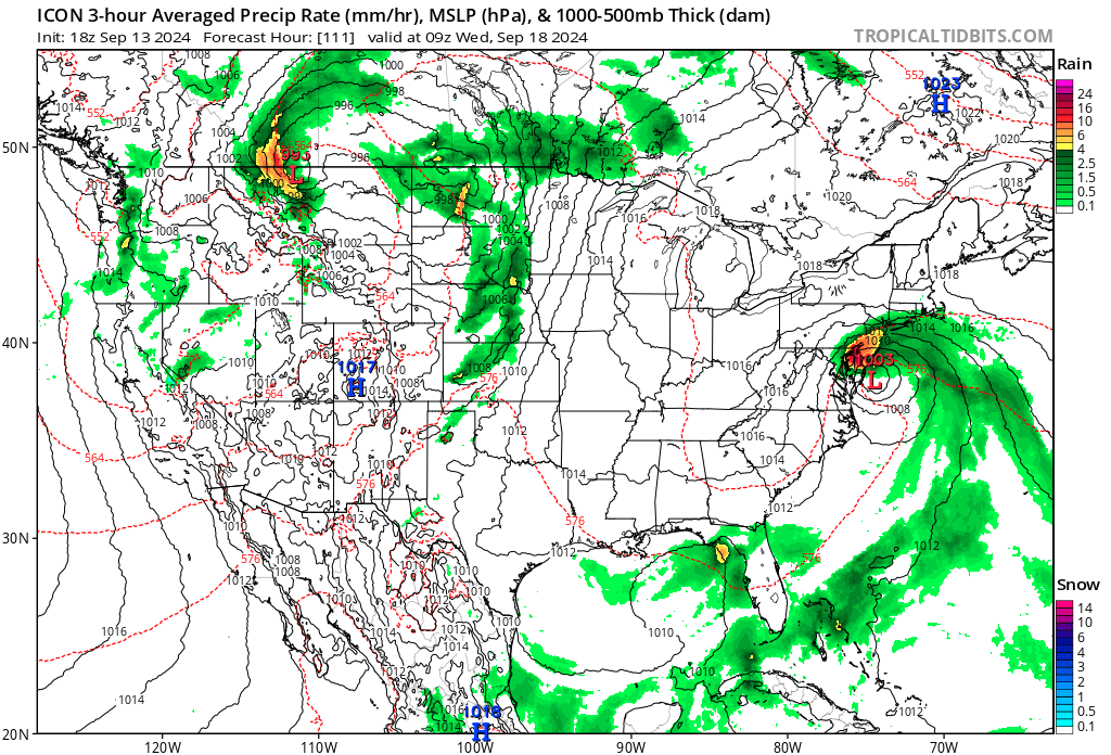
Not even a trace here you are lucky! Now we turn our attention to next weekend looks like a storm coming up from the south and then redeveloping off the Delmarva winter pattern arriving early so here come the big snows!!! Also, not sure of our La Nina / El Nino state but looking over the pattern really doesn't look too La Nina to me maybe weak El Nino conditions or even neutral conditions. GFS Model – MSLP & Precip (Rain/Frozen) for CONUS | Tropical Tidbits
-
2024 Atlantic Hurricane Season
Kevin Reilly replied to Stormchaserchuck1's topic in Tropical Headquarters
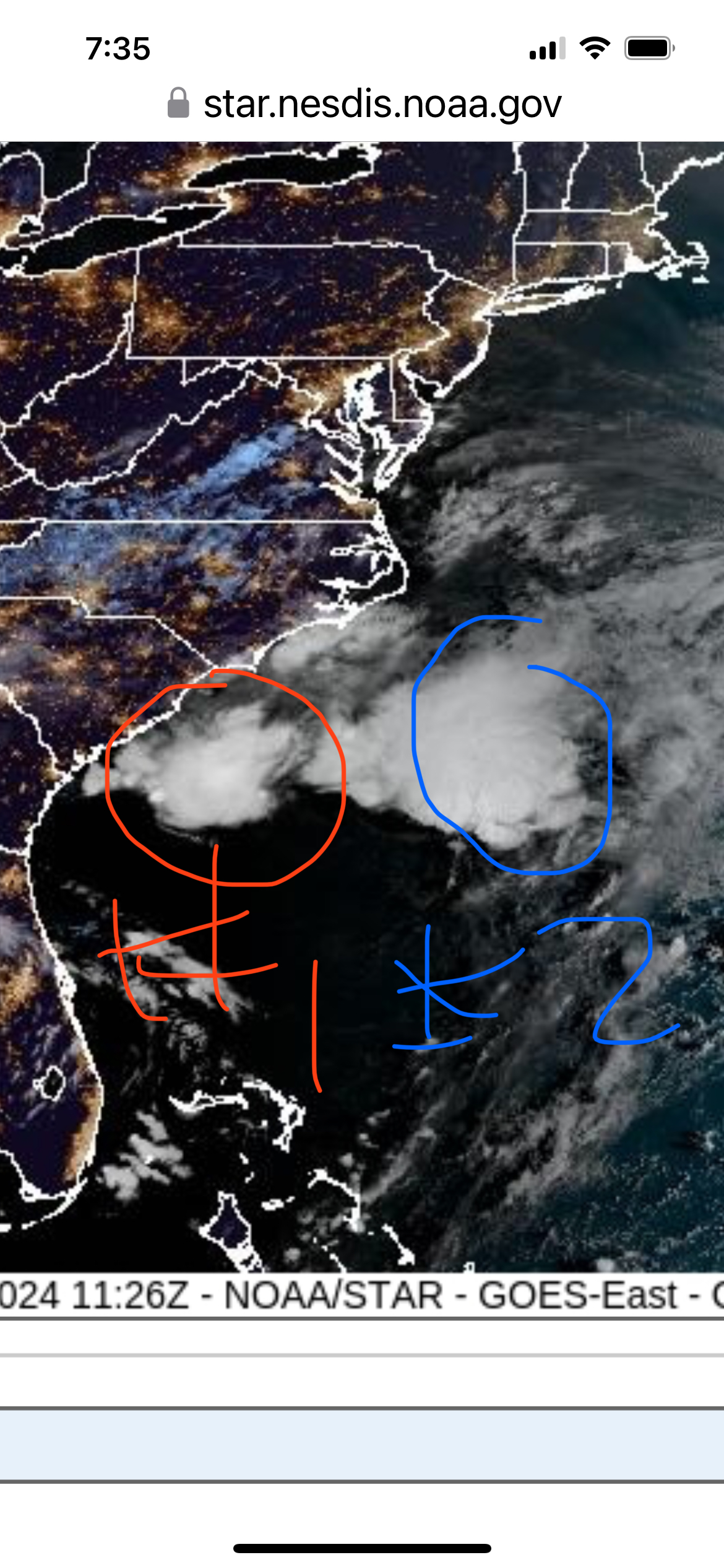
There are a couple of circulations I can see another very small directly to the east somewhat hiding underneath some high clouds both are naked swirls pretty good NW shear. Actually, I am wondering if that very small circulation is the ingredient for a coastal low up along the East Coast by September 7th?? Every model has a coastal low or low coming up from the south next weekend. GFS Model – MSLP & Precip (Rain/Frozen) for CONUS | Tropical Tidbits -
I am willing to bet we end the dry streak now and what we are going to have this week with a visit from a tropical system I would say most likely from the Gulf of Mexico by September 10th or so.
-
I am going to say we get zippo here tonight in Media.