

Kevin Reilly
-
Posts
3,402 -
Joined
-
Last visited
Content Type
Profiles
Blogs
Forums
American Weather
Media Demo
Store
Gallery
Everything posted by Kevin Reilly
-

January: Medium/ Long Range: May the Force be with Us....
Kevin Reilly replied to Weather Will's topic in Mid Atlantic
It’s a little too far south this is coming 75 miles further north. -
January: Medium/ Long Range: May the Force be with Us....
Kevin Reilly replied to Weather Will's topic in Mid Atlantic
Does February 11th 1983 count? -
E PA/NJ/DE Winter 2024/25 Obs/Discussion
Kevin Reilly replied to JTA66's topic in Philadelphia Region
Happy Christmas and all Holidays that you may celebrate! -
January: Medium/ Long Range: May the Force be with Us....
Kevin Reilly replied to Weather Will's topic in Mid Atlantic
I would expect the operational models to move towards last night’s 0z GEFS throughout the day and into the night today bringing more presents. -
January: Medium/ Long Range: May the Force be with Us....
Kevin Reilly replied to Weather Will's topic in Mid Atlantic
I’ve heard this before has to be added to the list from the other day. This cutter track is locked in. -
January: Medium/ Long Range: May the Force be with Us....
Kevin Reilly replied to Weather Will's topic in Mid Atlantic
See you for the 18z can't wait! -
E PA/NJ/DE Winter 2024/25 Obs/Discussion
Kevin Reilly replied to JTA66's topic in Philadelphia Region
However, my Christmas thoughts are that this could still move easily to the Ralph let's have patience speech if nothing is showing up by this Friday. -
E PA/NJ/DE Winter 2024/25 Obs/Discussion
Kevin Reilly replied to JTA66's topic in Philadelphia Region
All just about over here a few flakes, sleet, pellets, freezing rain drops left 30f dewpoint 24f 0.30" of snow, sleet, light glaze of freezing rain this is exactly what I thought would happen. The highest I can imagine falling from this band is 1" at best at least down here in this corner of southeast PA. While precipitating here temp was 27-29f Total snowfall / Sleet today 0.30" Total snowfall for the year 1.58" (we are doing better than last year because we had zero in December like most years) -
E PA/NJ/DE Winter 2024/25 Obs/Discussion
Kevin Reilly replied to JTA66's topic in Philadelphia Region
White Christmas achieved. We have nothing close to that here just a covering at best. -
E PA/NJ/DE Winter 2024/25 Obs/Discussion
Kevin Reilly replied to JTA66's topic in Philadelphia Region
Cloudy 27f dewpoint 20f mangled snowflakes mixed with sleet ground all covered white say 0.03" of accumulation mainly sleet, my expectations have been reached this will be outta here soon. If you are driving though down here damage done with sleet, flakes, and freezing rain mixing in at 27f careful on the roads. -
January: Medium/ Long Range: May the Force be with Us....
Kevin Reilly replied to Weather Will's topic in Mid Atlantic
See how long it lasts reality is temps in the 50's. This has been the cast last 5-10 years models show what should be happening and then revert to a climate change state. I know some say it dates back to 2016 but honestly it may have it's roots dating back to 1996. -
E PA/NJ/DE Winter 2024/25 Obs/Discussion
Kevin Reilly replied to JTA66's topic in Philadelphia Region
Currently Mostly Cloudy high-level clouds 25f dewpoint 10f. Winter Weather Advisory set 5 am to 1 pm ready for a few mangled snowflakes, sleet, then freezing rain let's go!!! -
E PA/NJ/DE Winter 2024/25 Obs/Discussion
Kevin Reilly replied to JTA66's topic in Philadelphia Region
-
E PA/NJ/DE Winter 2024/25 Obs/Discussion
Kevin Reilly replied to JTA66's topic in Philadelphia Region
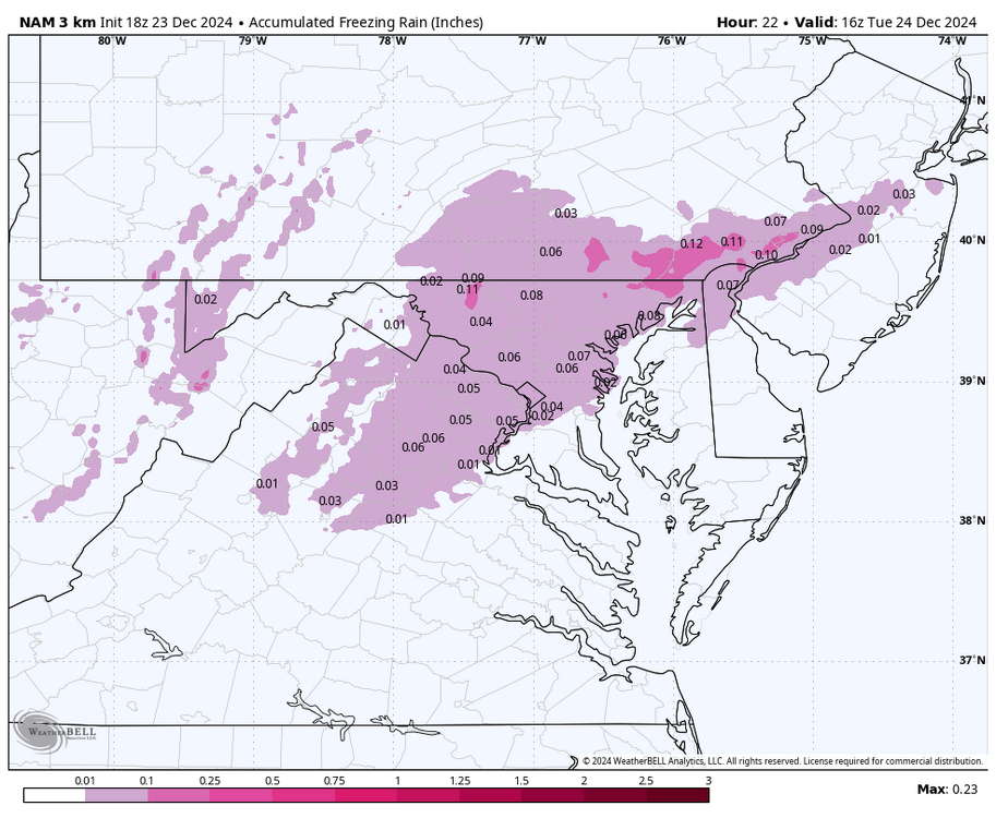
Clear currently 9f last night's low was 8.0f. It's only going up up up from here. However, before we go up could be trouble tomorrow morning between 7:00 am to 10:00 am with snow, sleet, some freezing rain looking at models it should remain below freezing entire area for this very light event. There is limited moisture for the system to work with as it is basically a weak cold front that will come through then lay stationary to our south to become our warm front to allow warming to take place over the course of next week. Looks like the moisture sleet and freezing rain opportunities are in the advisory areas shaded in purple. I am guessing that the areas to the north are not in advisories because mainly very light snow will fall with not much sleet and freezing rain and should just blow off the roads? I suppose they will make adjustments today as needed. -
E PA/NJ/DE Winter 2024/25 Obs/Discussion
Kevin Reilly replied to JTA66's topic in Philadelphia Region
Clear 14f here dew point 3f -
E PA/NJ/DE Winter 2024/25 Obs/Discussion
Kevin Reilly replied to JTA66's topic in Philadelphia Region
Sunny currently 20f low this morning was 10f. We are unfortunately losing grip of our white Christmas snow cover looks like mainly to evaporation as the dewpoints are running quite low as well. Snowfall left on the ground ranges from 0" to 1.0" -
January: Medium/ Long Range: May the Force be with Us....
Kevin Reilly replied to Weather Will's topic in Mid Atlantic
Soooo…. When was the last time this type of map worked out??? -
January: Medium/ Long Range: May the Force be with Us....
Kevin Reilly replied to Weather Will's topic in Mid Atlantic
That is what we lacked yesterday the storm track was too far east for us. -
E PA/NJ/DE Winter 2024/25 Obs/Discussion
Kevin Reilly replied to JTA66's topic in Philadelphia Region
Right on time!!! Spring will be too in a week when it hits 50f. -
E PA/NJ/DE Winter 2024/25 Obs/Discussion
Kevin Reilly replied to JTA66's topic in Philadelphia Region
yea wow!! nothing like that here that is clearly triple what we have here so nice! Marshmallow city... Keep the snowpack coming we needed it to get rid of this drought! -
light snow 32f 1.2" of snow here today only on grass, trees, roofs, cars but a pretty snow. 2-4" just to the NNE of me about 35 miles away so not too bad up here.
-
E PA/NJ/DE Winter 2024/25 Obs/Discussion
Kevin Reilly replied to JTA66's topic in Philadelphia Region
Now clearly at 1.2" but only on the grass still snowing light to moderate here now 32.1f Total Snow Year 1.2" grass only. with very little wind and high humidity levels and very wet roads I would expect icing black ice a real threat from here on out before developing wind to dry the roads out. I would think a Special Weather Statement or even a Winter Weather Advisory is needed for Delaware County due to icy roads the snow should be pulling out by midnight or so. -
E PA/NJ/DE Winter 2024/25 Obs/Discussion
Kevin Reilly replied to JTA66's topic in Philadelphia Region
32.4f light snow 0.08" only on the grass very little if anything on paved surfaces: roofs, cars, grass, trees covered. Snowing here since 3:00 pm temps started at 35f but through entire event 32.4f to 33.4f so melting yes. Otherwise, this would be a 2-4" event. I am not complaining at all! Total snowfall for the year 1.0" -
E PA/NJ/DE Winter 2024/25 Obs/Discussion
Kevin Reilly replied to JTA66's topic in Philadelphia Region
This is gravy then winter arrives at 4:21 am tomorrow morning so game on LOL. In all seriousness this is sooo nice with Christmas Lights and different from the past few years at least. -
E PA/NJ/DE Winter 2024/25 Obs/Discussion
Kevin Reilly replied to JTA66's topic in Philadelphia Region
light snow 32f dewpoint 32f 0.04" on cars, grass, mulch, trees, zero on paved surfaces just wet. I like it my expectations met maybe we can squeeze out the measurement Media has enjoyed a lot over the past 6 years 0.07"


