Kevin Reilly
-
Posts
3,401 -
Joined
-
Last visited
Content Type
Profiles
Blogs
Forums
American Weather
Media Demo
Store
Gallery
Everything posted by Kevin Reilly
-

E PA/NJ/DE Winter 2024/25 Obs/Discussion
Kevin Reilly replied to JTA66's topic in Philadelphia Region
All the reasons why when we get a 20"+ storm it is a Special Event! -
January: Medium/ Long Range: May the Force be with Us....
Kevin Reilly replied to Weather Will's topic in Mid Atlantic
Fluff factor / snow ratio more cold less liquid more snow. -
E PA/NJ/DE Winter 2024/25 Obs/Discussion
Kevin Reilly replied to JTA66's topic in Philadelphia Region
Heavy drizzle 47f humidity 99% dew point 46f total rainfall: 0.51” -
E PA/NJ/DE Winter 2024/25 Obs/Discussion
Kevin Reilly replied to JTA66's topic in Philadelphia Region
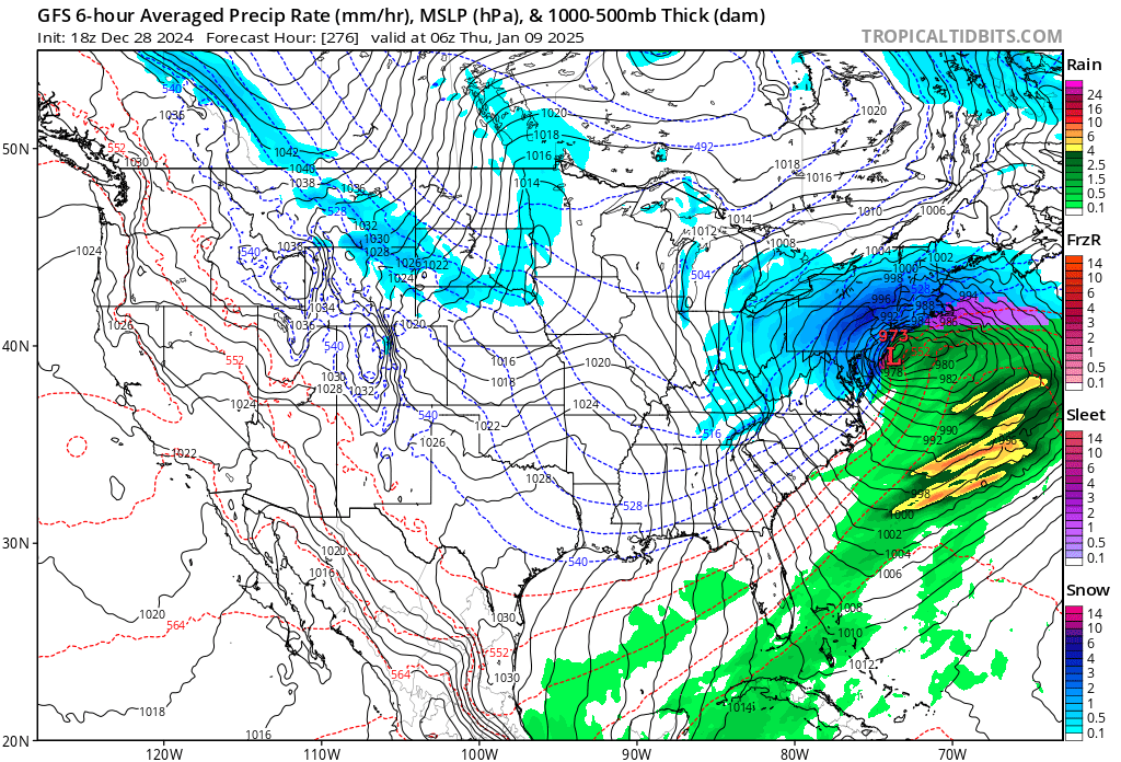
I’ll take 973 mb storm for 1000 Alex
-
January: Medium/ Long Range: May the Force be with Us....
Kevin Reilly replied to Weather Will's topic in Mid Atlantic
Lots of upward motions thunderstorms with heavy sleet. That storm there is a historic classic storm. -
January: Medium/ Long Range: May the Force be with Us....
Kevin Reilly replied to Weather Will's topic in Mid Atlantic
Storm total at PHL was 31” -
January: Medium/ Long Range: May the Force be with Us....
Kevin Reilly replied to Weather Will's topic in Mid Atlantic
That actually was 1/7/96-1/8/96 -
E PA/NJ/DE Winter 2024/25 Obs/Discussion
Kevin Reilly replied to JTA66's topic in Philadelphia Region
46f low clouds, fog, drizzle Total rainfall so far 0.49" -
E PA/NJ/DE Winter 2024/25 Obs/Discussion
Kevin Reilly replied to JTA66's topic in Philadelphia Region
Umm wow the three hour change pretty remarkable temp rise from 33.2 dewpoint 25 to 39.5 dewpoint 33 light to moderate rain now falling. -
January: Medium/ Long Range: May the Force be with Us....
Kevin Reilly replied to Weather Will's topic in Mid Atlantic
Bring that to the Baja across northern Mexico or along the border to southeast Texas then move to Fort Walton beach and combine with a northern branch system southeast of Atlanta Georgia then crawl northward to Ocean City Md then ease out to sea to the NE. -
E PA/NJ/DE Winter 2024/25 Obs/Discussion
Kevin Reilly replied to JTA66's topic in Philadelphia Region
33.2f dewpoint actually fell to 25f skies clear to partly cloudy. Waiting for: 1. Rain 2. Warm 3. Cold 4. Snow -
January: Medium/ Long Range: May the Force be with Us....
Kevin Reilly replied to Weather Will's topic in Mid Atlantic
screams rain to snow event 2-4" / 3-5" -
January: Medium/ Long Range: May the Force be with Us....
Kevin Reilly replied to Weather Will's topic in Mid Atlantic
Thinking back to the ensembles from a few days ago. Honestly, I think it gets busy in here starting sooner rather than later say this Saturday into Sunday. -
E PA/NJ/DE Winter 2024/25 Obs/Discussion
Kevin Reilly replied to JTA66's topic in Philadelphia Region
Duca892 I will take it down another level lol: Last night's low 22f here currently 35f (kiss those Temps goodbye down here on the west side of the Delaware River) Looking forward to warm and wet incoming maybe a bit of freezing rain to the NNE of us later tonight very early tomorrow hence the winter weather advisories up there. I am looking forward to some much-needed rain again to attempt to fill the reservoirs but very warm. It is even possible to see a rare December thunderstorm on Sunday during the Eagles Game. Sorry Duca892 for the rest of December it 100% is sh_t the blinds time. As for January the only thing that can be said is we get cold over time but look on the bright side we have had 1.58" of snow at least down here others more others less so we are still doing better than last year. I do believe we see normal snowfall this year or at least I hope we do for Drought's sake. I still do hold hope for January certainly not dead yet and it does believe it or not at least to me have a normal feel to it honestly dating back many years to the 70's and 80's. I do think we get snowed on in January I will go with 8-14". -
January: Medium/ Long Range: May the Force be with Us....
Kevin Reilly replied to Weather Will's topic in Mid Atlantic
You have to be a teacher?? -
January: Medium/ Long Range: May the Force be with Us....
Kevin Reilly replied to Weather Will's topic in Mid Atlantic
That might be right if I get 3-5" up here LOL -
January: Medium/ Long Range: May the Force be with Us....
Kevin Reilly replied to Weather Will's topic in Mid Atlantic
Got 3-5" -
E PA/NJ/DE Winter 2024/25 Obs/Discussion
Kevin Reilly replied to JTA66's topic in Philadelphia Region
It has been partly sunny most of the day to this point right now. It is more like mostly cloudy currently. High so far today has been 37f. -
January: Medium/ Long Range: May the Force be with Us....
Kevin Reilly replied to Weather Will's topic in Mid Atlantic
I see phrases such as: We are bipolar We can get stiffed like every year Be patient let the pattern play out Better bone dry cold then warm and wet at least we have the most important player on the field One that many may forget maybe the operational models are off a bit because the mets that work them are off for the holidays the models will come around when everyone comes back to work. -
January: Medium/ Long Range: May the Force be with Us....
Kevin Reilly replied to Weather Will's topic in Mid Atlantic
It would be terrible news for the drought up in this neck of the woods reservoirs are down still 20 feet or so. -
January: Medium/ Long Range: May the Force be with Us....
Kevin Reilly replied to Weather Will's topic in Mid Atlantic
Love the +PNA hello old friend where have you been?? -
January: Medium/ Long Range: May the Force be with Us....
Kevin Reilly replied to Weather Will's topic in Mid Atlantic
Clear developing split flow may take away. I think we need a split flow to make things interesting. -
E PA/NJ/DE Winter 2024/25 Obs/Discussion
Kevin Reilly replied to JTA66's topic in Philadelphia Region
Soo..... what happened to Mostly Sunny high 38 today??? Got the temp right but the sun hasn't made an appearance at any point today. Sounds like a pretty blown forecast at very short leads. Must be an inversion layer those are always pains to forecasts. -
January: Medium/ Long Range: May the Force be with Us....
Kevin Reilly replied to Weather Will's topic in Mid Atlantic
It’s a little too far south this is coming 75 miles further north.