Kevin Reilly
-
Posts
3,401 -
Joined
-
Last visited
Content Type
Profiles
Blogs
Forums
American Weather
Media Demo
Store
Gallery
Everything posted by Kevin Reilly
-

January Medium/Long Range: A snowy January ahead?
Kevin Reilly replied to mappy's topic in Mid Atlantic
1 jog to the west and its Folks time! -
1/6 snowstorm - nuisance event or something bigger?
Kevin Reilly replied to LVblizzard's topic in Philadelphia Region
28f humidity 92% dp 25 pixe dust flakes left over. added another .20” so snow total 2.0” Total year 4.88” Hey a nuisance event here! -
January Medium/Long Range: A snowy January ahead?
Kevin Reilly replied to mappy's topic in Mid Atlantic
Wind machine! Is this coastal any relation to the absolute monster right now up in the Gulf of Alaska heading north? -
1/6 snowstorm - nuisance event or something bigger?
Kevin Reilly replied to LVblizzard's topic in Philadelphia Region
28f humidity 85% dp 24 light steady snow has begun! Part 2 underway! under over 1.8” lol We are so focused on 5 days that we fail to see what’s right in front of us! This has been happening since New Year Eve thunderstorms with hail! I’m enjoying the winter of 2024-2025 so far! let me get the shovel ready again! Who cares about Saturday lol Quote -
E PA/NJ/DE Winter 2024/25 Obs/Discussion
Kevin Reilly replied to JTA66's topic in Philadelphia Region
28f humidity 85% dp 24 light steady snow has begun! Part 2 underway! under over 1.8” lol We are so focused on 5 days that we fail to see what’s right in front of us! This has been happening since New Year Eve thunderstorms with hail! I’m enjoying the winter of 2024-2025 so far! let me get the shovel ready again! Who cares about Saturday lol -
January Medium/Long Range: A snowy January ahead?
Kevin Reilly replied to mappy's topic in Mid Atlantic
Well if this is one and done I stop at 4.68” for the year lol -
1/6 snowstorm - nuisance event or something bigger?
Kevin Reilly replied to LVblizzard's topic in Philadelphia Region
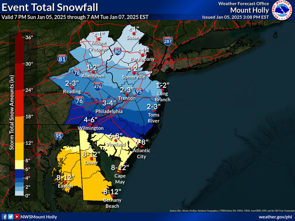
Lol that is why I said most guidance LOL. To say I am disappointed is an understatement but we down here in Delco joined the rest of the people who got 2" or less. Yes, we did have a Winter Storm Warming for 3-6" but being on the northern fringe I cannot say I am surprised. My under over here was 3.6" so I got 1.8" and missed my under and over by 1.8" how about those numbers working out. Yea it was a bust overall thought I would at least get 3" LOL. You're right! -
1/6 snowstorm - nuisance event or something bigger?
Kevin Reilly replied to LVblizzard's topic in Philadelphia Region
Done here sun breaking through clouds low level clouds drifting SW. 29f humidity 77% dp 24 Total snow here 1.8” Total for the year: 4.68” Dry air and confluence real! overall good job by most of the models -
January Medium/Long Range: A snowy January ahead?
Kevin Reilly replied to mappy's topic in Mid Atlantic
Euro at 0z looks exactly like the 12z gfs tonight. -
1/6 snowstorm - nuisance event or something bigger?
Kevin Reilly replied to LVblizzard's topic in Philadelphia Region
Very light snow here sun poking through clouds a bit 28f humidity 83% dp 24f Total snow 1.6” Total for year 3.48” -
1/6 snowstorm - nuisance event or something bigger?
Kevin Reilly replied to LVblizzard's topic in Philadelphia Region
Yes this is flying east very quickly should clear the Delaware River by or just before 12 noon wow Shazam. I’m happy with what we get. Get this storm outta here so we can get mauled this weekend? -
1/6 snowstorm - nuisance event or something bigger?
Kevin Reilly replied to LVblizzard's topic in Philadelphia Region
26f humidity 88% dew point 23 heaviest rates of the day SN to SN+ 1.2” total total for year 3.08” for the year -
1/6 snowstorm - nuisance event or something bigger?
Kevin Reilly replied to LVblizzard's topic in Philadelphia Region
Those reds and yellows just south of Delaware has to be sleet right? -
1/6 snowstorm - nuisance event or something bigger?
Kevin Reilly replied to LVblizzard's topic in Philadelphia Region
Decent banding coming together Chester and Lancaster County heading eastward slightly east northeast. Reflectivity -
1/6 snowstorm - nuisance event or something bigger?
Kevin Reilly replied to LVblizzard's topic in Philadelphia Region
24f humidity 85% dp 21f -SN to SN variable rates Total so far 0.60” main roads wet all others snow covered Total for the year: 2.48” -
1/6 snowstorm - nuisance event or something bigger?
Kevin Reilly replied to LVblizzard's topic in Philadelphia Region
Snow began at 6:10 am or so here in Media. Light snow 24.3f humidity 78% dp 18 total snow so far .20 all surfaces covered total snow for year 2.08” -
1/6 snowstorm - nuisance event or something bigger?
Kevin Reilly replied to LVblizzard's topic in Philadelphia Region
Come on me and Kamu can get this! Media lies about 8 miles from the Delaware line Kamu is probably 3-4 miles lets go!! -
E PA/NJ/DE Winter 2024/25 Obs/Discussion
Kevin Reilly replied to JTA66's topic in Philadelphia Region
Ralph did say be patient lol!
-
1/6 snowstorm - nuisance event or something bigger?
Kevin Reilly replied to LVblizzard's topic in Philadelphia Region
Water Vapor map has a pretty good flow of moisture all the way to Detroit at this time and into the Great Lakes kind of interesting as everything starts moving off to the east. You can see the confluence in the Gulf of Maine. Pennsylvania Water Vapor Satellite Weather Map | AccuWeather Just some interesting now casting tibits. -
1/6 snowstorm - nuisance event or something bigger?
Kevin Reilly replied to LVblizzard's topic in Philadelphia Region
-
1/6 snowstorm - nuisance event or something bigger?
Kevin Reilly replied to LVblizzard's topic in Philadelphia Region
Losing the lowering dim sun in the southwestern sky. 29f humidity 45% dewpoint 10 snow bar set at 3.6” -
1/6 snowstorm - nuisance event or something bigger?
Kevin Reilly replied to LVblizzard's topic in Philadelphia Region
Just need another 40-45 mile push northeast can it happen???? -
1/6 snowstorm - nuisance event or something bigger?
Kevin Reilly replied to LVblizzard's topic in Philadelphia Region
To me coming to agreement on 2-4” extreme SE Pa south of the Turnpike 1-3” north of that then 1-2” Lehigh Valley to coating to 1” Poconos. The only wild card I can think of does the confluence lift out at the very last minute think the gfs showed this back on Fridays 12z run; something to keep an eye on. -
1/6 snowstorm - nuisance event or something bigger?
Kevin Reilly replied to LVblizzard's topic in Philadelphia Region
Hey Paul kuddos to you! Many days ago you were worried about the confluence and suppression and here we are! Damm!! Better luck next weekend? Hopefully the storm next weekend doesn’t cut to our west? That would be a disaster! -
1/6 snowstorm - nuisance event or something bigger?
Kevin Reilly replied to LVblizzard's topic in Philadelphia Region
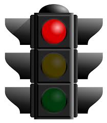
And falling fast! I would expect it to move towards everything else. The confluence is just too strong for this system to punch any further northeast. It’s hitting the proverbial red light!