

Kevin Reilly
-
Posts
3,401 -
Joined
-
Last visited
Content Type
Profiles
Blogs
Forums
American Weather
Media Demo
Store
Gallery
Everything posted by Kevin Reilly
-

Sunday 1/19 Eagles Game Snow and Stuff
Kevin Reilly replied to Ralph Wiggum's topic in Philadelphia Region
Think we may be at the beginning of the models picking up on the progressive nature of the flow with no blocking and the cold air allowed to slosh east southeast. -
1/19 - The Weekend Roulette Wheel Thing
Kevin Reilly replied to DDweatherman's topic in Mid Atlantic
Think we may be at the beginning of the models picking up on the progressive nature of the flow with no blocking and the cold air allowed to slosh east southeast. -
Sunday 1/19 Eagles Game Snow and Stuff
Kevin Reilly replied to Ralph Wiggum's topic in Philadelphia Region
Here comes the cave at the last hour! -
Sunday 1/19 Eagles Game Snow and Stuff
Kevin Reilly replied to Ralph Wiggum's topic in Philadelphia Region
Maybe Redsky should cup his hands and start blowing towards the southeast to see if that might move the baroclinic zone just a little further southeast? -
Sunday 1/19 Eagles Game Snow and Stuff
Kevin Reilly replied to Ralph Wiggum's topic in Philadelphia Region
So looks like we have ways to go here. Nam more progressive colder drier solution… ggem more amped slower with the cold dry air getting here..,, gfs just right amount of moisture left to get wrung out. This reminds me of December 8th 2013 Eagles Lions game. Quick light rain 35-40 then fall quickly into the mid upper 20s 26 with moderate to heavy snow for 4-5 hours then outta here becoming windy and temps falling into the teens by 11 pm -
Sunday 1/19 Eagles Game Snow and Stuff
Kevin Reilly replied to Ralph Wiggum's topic in Philadelphia Region
This snow line is going to get interesting really close here in Media GFS has like 7.2" for Media but less than 5" is not far away at all. This will be interesting to see how this unfolds. -
Sunday 1/19 Eagles Game Snow and Stuff
Kevin Reilly replied to Ralph Wiggum's topic in Philadelphia Region
Okay so I’m sure they are going to play the winter weather advisory card then upgrade to a winter storm warning in progress route. Doesn’t matter all Eagles fans will be safely in the nest since most will arrive between 7:30 to 12:00 noon. I have no problem at all about this it’s likely the correct call. -
Sunday 1/19 Eagles Game Snow and Stuff
Kevin Reilly replied to Ralph Wiggum's topic in Philadelphia Region
Named in Media!!! Who’s next? -
1/19 - The Weekend Roulette Wheel Thing
Kevin Reilly replied to DDweatherman's topic in Mid Atlantic
There will not be any warm air coming off the Atlantic here is a picture of Townsend’s Inlet in Sea Isle City Cape May County NJ water temp 34f . These are slushy waves breaking onto the beach.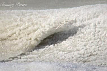
-
1/19 - The Weekend Roulette Wheel Thing
Kevin Reilly replied to DDweatherman's topic in Mid Atlantic
Doesn’t really make sense pretty progressive flow nothing can really amp up and bomb out too quickly cold press is real too easing everything on off to the east. -
Sunday 1/19 Eagles Game Snow and Stuff
Kevin Reilly replied to Ralph Wiggum's topic in Philadelphia Region
Agree classic snow up from the SSW then everything collapses southeast getting colder as she goes with better snow ratios north and west. -
1/19 - The Weekend Roulette Wheel Thing
Kevin Reilly replied to DDweatherman's topic in Mid Atlantic
Bonus too you can watch a snow bowl in Philadelphia -
Sunday 1/19 Eagles Game Snow and Stuff
Kevin Reilly replied to Ralph Wiggum's topic in Philadelphia Region
Kind of classic significant east coast snowstorm. -
Sunday 1/19 Eagles Game Snow and Stuff
Kevin Reilly replied to Ralph Wiggum's topic in Philadelphia Region
Hmmm looks bandy??? Dynamic per snowfall map. -
Sunday 1/19 Eagles Game Snow and Stuff
Kevin Reilly replied to Ralph Wiggum's topic in Philadelphia Region
Convective feedback! Yep we back! -
1/19 - The Weekend Roulette Wheel Thing
Kevin Reilly replied to DDweatherman's topic in Mid Atlantic
Just have to spackle the holes that’s all no big deal. -
1/19 - The Weekend Roulette Wheel Thing
Kevin Reilly replied to DDweatherman's topic in Mid Atlantic
Lots of holes in its game! -
1/19 - The Weekend Roulette Wheel Thing
Kevin Reilly replied to DDweatherman's topic in Mid Atlantic
Yes it will shift 175 miles southeast next run. -
Sunday 1/19 Eagles Game Snow and Stuff
Kevin Reilly replied to Ralph Wiggum's topic in Philadelphia Region
Predictable normal times are officially Back! -
Sunday 1/19 Eagles Game Snow and Stuff
Kevin Reilly replied to Ralph Wiggum's topic in Philadelphia Region
Yes think back to last storm that drove it north giving us 8-14” then 4 runs later we dwindled to 1-2” lol -
Sunday 1/19 Eagles Game Snow and Stuff
Kevin Reilly replied to Ralph Wiggum's topic in Philadelphia Region
Wow classic hit!!! -
1/19 - The Weekend Roulette Wheel Thing
Kevin Reilly replied to DDweatherman's topic in Mid Atlantic
How about the DGEX model still around? -
E PA/NJ/DE Winter 2024/25 Obs/Discussion
Kevin Reilly replied to JTA66's topic in Philadelphia Region
Light snow 25.2f humidity 84% dew point 21f Total snow now at 0.8" Total for the year 5.93" I am going to have to go out and shovel between periods watching the Flyers. -
E PA/NJ/DE Winter 2024/25 Obs/Discussion
Kevin Reilly replied to JTA66's topic in Philadelphia Region
This event looming for Sunday has me thinking and remembering the December 8th 2013 snow game Eagles Vs. Lions 34-20 final score. This set up looks eerily similar for Sunday in regard to storm track and possible results. Eagles 34-20 Lions (Dec 8, 2013) Final Score - ESPN -
1/19 - The Weekend Roulette Wheel Thing
Kevin Reilly replied to DDweatherman's topic in Mid Atlantic
Isn't that a little late. I was thinking hoping by 12z tomorrow.


