Kevin Reilly
-
Posts
3,401 -
Joined
-
Last visited
Content Type
Profiles
Blogs
Forums
American Weather
Media Demo
Store
Gallery
Everything posted by Kevin Reilly
-

February 15-16 Slop Fest/Rain/Wind OBS
Kevin Reilly replied to Mikeymac5306's topic in Philadelphia Region
Cloudy sun peaking out 34f humidity 52% dew point 18f under over snow 0.4” under over rain 1.55” under over wind 44 mph -
So it does the NAM thing then chasing convection south of us right out to sea and not phasing because honestly it looked like the 6z gfs was also doing this as well to a degree.
-
Here comes a weenie handbook phrase: “Let’s split the difference!”
-
Miller A
-
It’s the ribeyes fault it must have been damn Goooood!!
-
Yes yesterday at 12z
-
Hope the ribeye was awesome!!
-
E PA/NJ/DE Winter 2024/25 Obs/Discussion
Kevin Reilly replied to JTA66's topic in Philadelphia Region
Increasing cloudiness 26f humidity 53% dew point 12f wind calm. -
E PA/NJ/DE Winter 2024/25 Obs/Discussion
Kevin Reilly replied to JTA66's topic in Philadelphia Region
Unless the gfs and Euro AI are too focused on the southern shortwave heading out. -
E PA/NJ/DE Winter 2024/25 Obs/Discussion
Kevin Reilly replied to JTA66's topic in Philadelphia Region
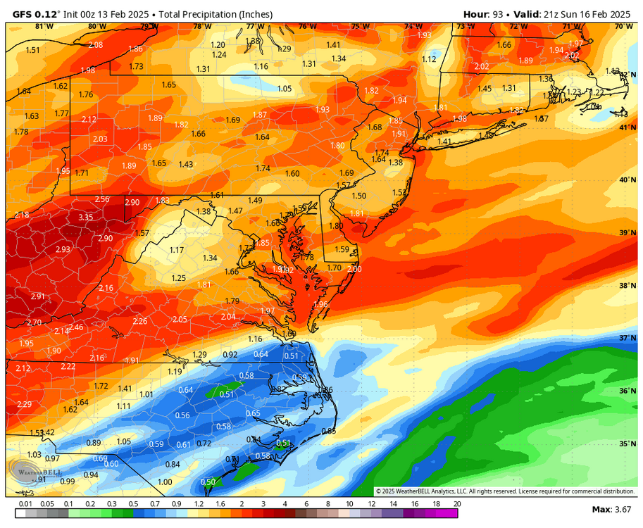
I mean seriously everything right now is a total wait and see but models are nice to look at. The speed and movements of the pieces are going to change over the next 24-48 hours I believe especially once our power house storm leaves Sunday. Once again we are staring at an interesting storm coming in tomorrow to Sunday complete with snow to rain possibly thunderstorms for some followed by power outage 50 mph gusts Sunday into Monday, but yet we find ourselves looking beyond to what is coming in 4.5 days we have been doing this since the thunderstorm hail fest right before Christmas. I’m still in the camp a lot of things can go wrong with this set up the one I fear most is the guide stage right out to sea and or develop too late and bury New England time will tell. If 20” is still on the table come Monday night I’m really excited! -
Screams progressive flow knock it east regime which is plausible at this lead.
-
Shades of 1996 with this model showing this while Euro just moves on northeast.
-
Holy Fook!!! FOLKS!!!
-
Gfs snowfall map looks very wonky in SE Pennsylvania I’ve never seen a solution like that toss!
-
Possible line of thunderstorms too!
-
E PA/NJ/DE Winter 2024/25 Obs/Discussion
Kevin Reilly replied to JTA66's topic in Philadelphia Region
In the what can go wrong department I can see the storm developing too late we get some snow 3-6” but the big winners is New England when they get 2-3 feet. -
E PA/NJ/DE Winter 2024/25 Obs/Discussion
Kevin Reilly replied to JTA66's topic in Philadelphia Region
We take but we know this is changing like 10 more times and probably is a southern New England crusher while we get 4-6” we can dream though!
-
E PA/NJ/DE Winter 2024/25 Obs/Discussion
Kevin Reilly replied to JTA66's topic in Philadelphia Region
I’ll take this sure!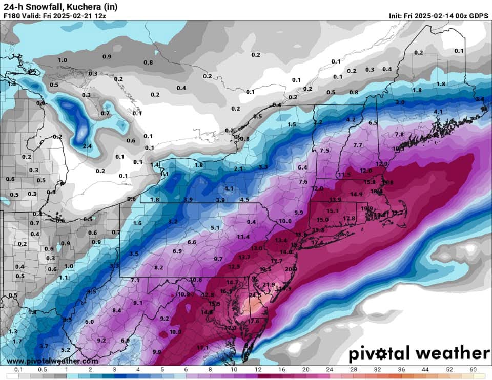
-
E PA/NJ/DE Winter 2024/25 Obs/Discussion
Kevin Reilly replied to JTA66's topic in Philadelphia Region
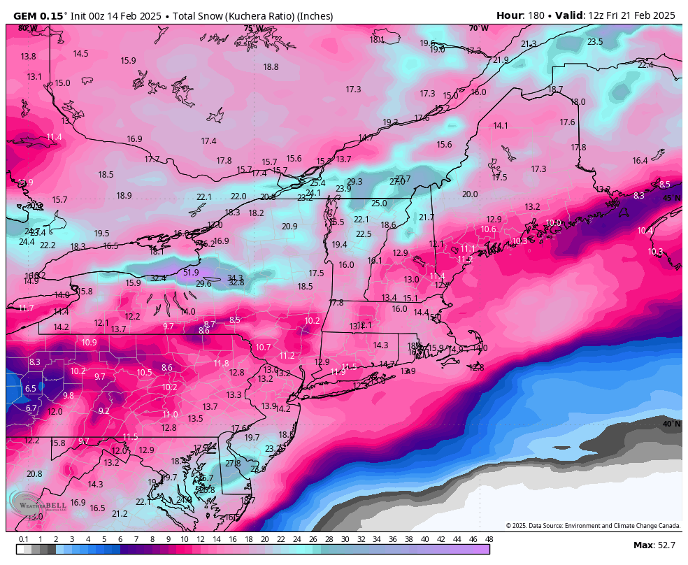
Boston 4 feet need to get the pretty maps! Decent trend. -
E PA/NJ/DE Winter 2024/25 Obs/Discussion
Kevin Reilly replied to JTA66's topic in Philadelphia Region
Power out trees down I guess. -
E PA/NJ/DE Winter 2024/25 Obs/Discussion
Kevin Reilly replied to JTA66's topic in Philadelphia Region
Yea winds gusting here to near 40 mph from the northwest right now temps falling 45 currently all snowpack gone!! However cold air advection well underway! -
Sleet probably skewing maybe especially southeast?
-
You know this has been happening a lot this year we are looking at beyond hour 145 just to have something knocking on the door that’s interesting either happening or about to happen in 48 hours. This has been happening since the December thunderstorms that dropped multiple episodes of hail.
-
E PA/NJ/DE Winter 2024/25 Obs/Discussion
Kevin Reilly replied to JTA66's topic in Philadelphia Region
Hmmm sleet -
E PA/NJ/DE Winter 2024/25 Obs/Discussion
Kevin Reilly replied to JTA66's topic in Philadelphia Region
Followed by this give me three of these to ease drought guy and me.