Kevin Reilly
-
Posts
3,401 -
Joined
-
Last visited
Content Type
Profiles
Blogs
Forums
American Weather
Media Demo
Store
Gallery
Everything posted by Kevin Reilly
-
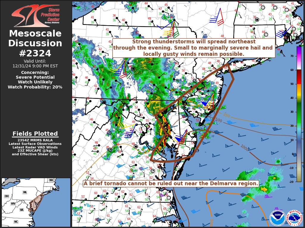
Rain will be through NYC by say 11:00 pm rapidly moving NE. Clear low center just southwest of Allentown, PA.
-
46f dead calm winds and skies are now partly cloudy to clear here. 0.50" Wild night here winds gusted past 40 mph a few times and had not 1, not 2, but 3 storms with hail. The second storm the hail was pea to marble size and covered the ground and cars too lots of cloud to ground lightning strikes wild signal for the beginning of our pattern change! Wow night! Happy New Year all!
-

E PA/NJ/DE Winter 2024/25 Obs/Discussion
Kevin Reilly replied to JTA66's topic in Philadelphia Region
That's one impressive radar for December 31st just wow!! NWS Radar -
E PA/NJ/DE Winter 2024/25 Obs/Discussion
Kevin Reilly replied to JTA66's topic in Philadelphia Region
You can see the pattern change happening before your eyes on the water vapor map pretty amazing. It is flipping storm over us headed to set up the confluence and bring the cold out of Canada. You can see everything collapsing down from eastern Alaska and the Yukon so here comes the cold charging SE. Forget the models right now but you can see an emerging winter pattern easily on the water vapor map. -
E PA/NJ/DE Winter 2024/25 Obs/Discussion
Kevin Reilly replied to JTA66's topic in Philadelphia Region
Looks like bow echo to the south and east is getting energized again and moving North Northeast. temp up a degree here to 48f remain in a dry slot. -
E PA/NJ/DE Winter 2024/25 Obs/Discussion
Kevin Reilly replied to JTA66's topic in Philadelphia Region
Just got dry slotted LOL 47f Looks like the line to my south now moving west northwest. -
E PA/NJ/DE Winter 2024/25 Obs/Discussion
Kevin Reilly replied to JTA66's topic in Philadelphia Region
Geeze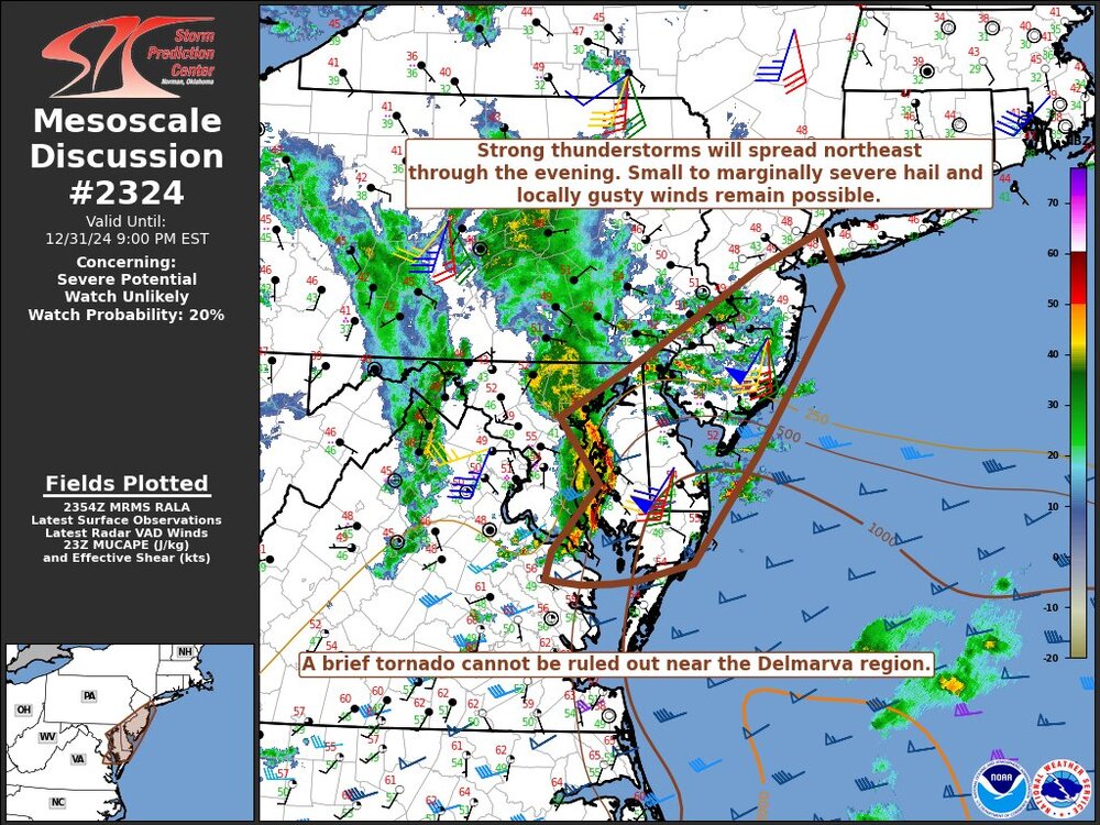
-
E PA/NJ/DE Winter 2024/25 Obs/Discussion
Kevin Reilly replied to JTA66's topic in Philadelphia Region
Looks like another solid line developing in NE Maryland and northern Delaware heading quickly North wow this is a very active night! A New Years Eve to remember lol. Total rainfall 0.40" so far with a covering of hail. Happy New Years all! -
E PA/NJ/DE Winter 2024/25 Obs/Discussion
Kevin Reilly replied to JTA66's topic in Philadelphia Region
47f we just had a storm that covered the ground and cars with pea size hail wow strikes included!! Wow 3rd round of hail now 7:25 pm pea to marble size. -
E PA/NJ/DE Winter 2024/25 Obs/Discussion
Kevin Reilly replied to JTA66's topic in Philadelphia Region
48f summer like downpours thunder and now some hail to boot wild stuff! That's a pretty good bow echo going through the Chesapeake Bay right now rotating and make the turn NNE wow!! Dynamics at work. -
E PA/NJ/DE Winter 2024/25 Obs/Discussion
Kevin Reilly replied to JTA66's topic in Philadelphia Region
49f a few downpours. Thunderstorms rotating up from the South to due north wild!!!! We have thunder here. Wind here at the surface at the moment is out of the North but thunderstorms are heading due south to north interesting. Pretty dynamic set up if you ask me. Also, models are completely clue less of what to do beyond say next 1-3 days let alone a week out. This dynamic storm here tonight will have a lot to say as to what confluence is set up. -
January: Medium/ Long Range: May the Force be with Us....
Kevin Reilly replied to Weather Will's topic in Mid Atlantic
Yes, that was me. I was watching water vapor and the storms off the west coast of Central America and Mexico were heading west bound well south of Hawaii. There is a low that is pretty much stationary SE of Hawaii, and you can clearly see the STJ activating from that storm towards Mexico, the desert southwest though Texas and over to Atlanta Georgia. -
January: Medium/ Long Range: May the Force be with Us....
Kevin Reilly replied to Weather Will's topic in Mid Atlantic
Euro just took extreme southeast pa where I am at from 7.3" to 0.7" with a stiff dry ene wind love these model runs today all of them we are totally back to normal winter in the Mid Atlantic at least we are tracking, and I am sure we are NOT DONE seeing more changes! This is where things are fun in my opinion. Let's bring on winter and I am just simply rooting for anyone that has not received snow the past few years and that is most. -
January: Medium/ Long Range: May the Force be with Us....
Kevin Reilly replied to Weather Will's topic in Mid Atlantic
looks very similar to the Euro.... up here in Southeast PA I would say loss of liquid available will be made up by snow ratio rates. -
E PA/NJ/DE Winter 2024/25 Obs/Discussion
Kevin Reilly replied to JTA66's topic in Philadelphia Region
Currently 54f quite warm still. Overnight rain 9:00 pm to midnight 0.30" winds during frontal passage last night gusted to 37 mph with the heavy rain. Rainfall Total last 3 days: 1.18" Changes are in sight. This time next week it very well could be snowing enjoy the warmth while it is here because soon it will be exiting stage right and off to the Northeast to begin to set up our block needed for very cold weather and potential for snowstorms between January 5th to 17th. -
E PA/NJ/DE Winter 2024/25 Obs/Discussion
Kevin Reilly replied to JTA66's topic in Philadelphia Region
Just had a line go through pretty intense 30 mph winds heavy wind driven downpours -
E PA/NJ/DE Winter 2024/25 Obs/Discussion
Kevin Reilly replied to JTA66's topic in Philadelphia Region
Currently 58f Windy winds SSW gusting 25-30 mph. High today was 65f Sprinkles right now Total rainfall today: Trace -
January: Medium/ Long Range: May the Force be with Us....
Kevin Reilly replied to Weather Will's topic in Mid Atlantic
Have seen a couple of storms down Southwest of the Baja moving west. I was looking at the water vapor last night and one such low was moving west out there. -
January: Medium/ Long Range: May the Force be with Us....
Kevin Reilly replied to Weather Will's topic in Mid Atlantic
Looks to me we had an energy split one piece south tornadoes across the south another piece went northwest of us we caught in the middle -
January: Medium/ Long Range: May the Force be with Us....
Kevin Reilly replied to Weather Will's topic in Mid Atlantic
Honestly looks like a cruising system dropping out of Canada carving out a trough clipper esque -
January: Medium/ Long Range: May the Force be with Us....
Kevin Reilly replied to Weather Will's topic in Mid Atlantic
Could be the typical have the storm lose the storm while we track something closer in time. Weren't the earlier runs of the GFS last week keying in on January 5th to 7th might just be a timing thing. -
E PA/NJ/DE Winter 2024/25 Obs/Discussion
Kevin Reilly replied to JTA66's topic in Philadelphia Region
It's amazing we will finish as you say: "We will finish the year not too far from normal annual rainfall." Yet Springton Reservoir down here in Central Delaware County is down 20 feet. Now with that said with our past 0.88" here and what is to come into the 15 of January I am willing to bet the tables have turned big time. I am going out on a limb here I think we see 2.5-3.5" liquid between today, December 29th and Wednesday, Jaunary 15th. I will also go with 8-14" of snow still in that time. -
January: Medium/ Long Range: May the Force be with Us....
Kevin Reilly replied to Weather Will's topic in Mid Atlantic
Yea higher snow ratios and you double this amount and, in some cases, triple it; with the type of cold that is coming high ratio snow is on the table for sure. -
E PA/NJ/DE Winter 2024/25 Obs/Discussion
Kevin Reilly replied to JTA66's topic in Philadelphia Region
Currently 55f cloudy the sun did make an appearance for about 5 minutes. Total rainfall from last storm: 0.88" (dumped the gauge for round 2 later today / will dump the gauge for round 3 later this week) Looks like a busted forecast down there in south Florida in Cape Coral where my friend lives. A tropical low got started last evening and dumped 2-4" of rain area wide to Naples. Low just made landfall 5 miles north of Naples and is headed east-northeast. The forecast for Cape Coral a few showers .10" at 2:00 pm. Reality winds gusting past 40 mph for a few hours last night and 2-4" of rain. Just gives you an idea that the STJ may be getting going so one of our ingredients to look forward to down the line. Blown forecasts to our south sometimes can lead to huge implications winter storm wise up this way at times.