

GaWx
-
Posts
18,239 -
Joined
Content Type
Profiles
Blogs
Forums
American Weather
Media Demo
Store
Gallery
Everything posted by GaWx
-
0Z Icon snow:
-
18Z Euro AI similar to GFS with 1-2” snow in good portion. This is another run with the unusual OH Valley low, which allow for warming SW winds, unusual for having a low in the Gulf. So, this allows for sfc temps to be warmer than usual when having precip with -3 to -4C 850s and thicknesses of 540:
-
18Z EPS: 30% of members are much quicker than Euro op in bringing precip toward the SE (aiming for ~1/10) than the 1/12 of the 12Z.
-
Furthermore, for the SE and especially compared to the last few years, is that really all that light? 0.5-1.5” over a pretty large area. Not anywhere near major but significant.
-
18Z GFS snow: and it’s all snow rather than IP/ZR since 850s are below 0C. Sfc low about 300 miles south of 12Z GFS.
-
Good chance. But 18Z GFS is actually colder than last run.
-
18Z GFS through 129: nothing noteworthy. Slightly colder push. Maybe will be colder when precip finally arrives in SE.
-
The last several consistently had an organized Gulf low with heavy precip.
-
12Z Euro AI is much drier as it has only a weak disturbance vs the well developed lows on recent runs:
-
See my edited post. I said the same.
-
I’d bet heavily that next week will be significantly colder than both 2/3-9 and 2/10-16 in the SE overall anomalywise. You should be happy because you don’t like cold unless it’s snowing and it usually isn’t snowing when cold.
-
They never said it was going to be 20 BN all next week. They had 1-2 days that cold (in and near 1/10-11). Their coldest Jan 6-12 run is this one (see below), which had mainly 12-15 BN in the SE. My point is that the Weeklies called for a cold period that week going back to forecasts issued 3 weeks ago after they had warmth in late Dec, which verified well. We’ll see how cold Jan 6-12 actually ends up being, of course, but it still looks solidly BN. Jan 10-11 are looking to come in less cold per recent trends but still solidly BN. It makes perfect sense to warm up a lot then per MJO, La Niña history, and indices’ trends looking well ahead.
-
Enjoy the cold while we have it because the Euro Weeklies, which have done very well overall recently (with the current cold that followed the prior warmth…all well predicted), today have it pretty mild throughout most of the lower 48 states Feb 3-16. Also, La Niña Febs are more often than not on the mild side.
-
Today’s Euro Weeklies, which have done very well overall recently (with the current cold that followed the prior warmth…all well predicted) have it pretty mild throughout most of the lower 48 states Feb 3-16.
-
More on average strength of Miller A lows causing major Atlanta snow or sleet, which is a rather modest 1008 mb Complete list of major 32 ATL SN/IP caused by Miller A's: estimate of lowest SLP while in GoM/near Gulf coast (other 7 weren't Miller A) (sub 1000 bolded) 2/12-13/14: 1003 1/9-10/11: 1008 2/12/10: 997 1/2-3/02: 1007 3/13/93: 976 1/18/92: 1011 1/7/88: 1018 1/22/87: 998 3/24/83: 1002 1/12-13/82: 1007 2/17-18/79: 1018 3/11/1960 1011 2/15/1958 1001 2/26/1952 1004 3/2/1942 1002 1/23/1940 1006 1/29-30/1936 1009 3/14/1924 1000 12/11-13/1917 1020 1/28/1904 1017 2/23/1901 1012 2/11-12/1899 1017 2/15-16/1895 1017 2/11-12/1895 1012 12/24-5/1894 1020 (barely discernible) 1/18-19/1893 1008 12/3-6/1886 1013 2/12-15/1885 1005 1/23/1885 1003 1/7-8/1884 1010 12/29/1880 1009 1/1/1877 1003 In ascending order of SLP: median/mean are 1008; only 3 of 32 sub 1000! 976 997 998 1000 1001 1002 1002 1003 1003 1003 1004 1005 1006 1007 1007 1008 1008 1009 1009 1010 1011 1011 1012 1012 1013 1017 1017 1017 1018 1018 1020 1020
-
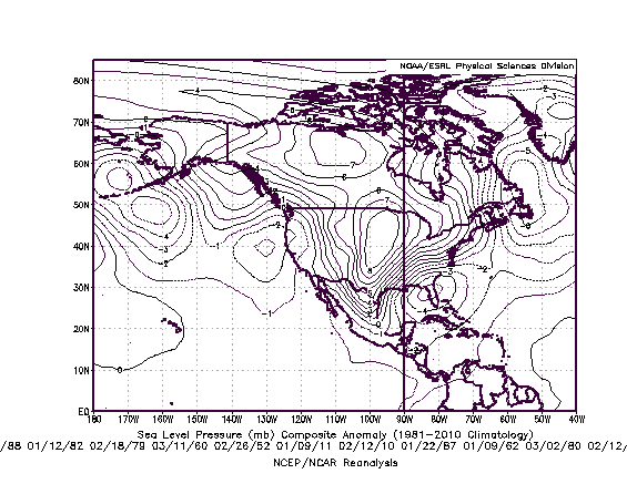
Here’s the mean SLP location of the lows having produced major Atlanta snow or sleet: crosses north central FL near an Ocala to St. Augustine line….so a “Southern Slider”. Also, note that the SLP mean anomaly isn’t overly strong….more about that later. Actually the mean anomaly of the Plains high is stronger per this map. Amped up lows (the Storm of the Century notwithstanding) usually aren’t good for ATL to AHN due to too much warm air being introduced and often a too far NW path associated with them. So, when you get amped up storms, they’re usually rainstorms.
-
-
12Z EPS through Jan 11th: notable snow for good portion of area on only ~10 (20%) of members: enough to keep hope alive?
-
Agreed. But not looking good for most of the SE as of recent trends. Next week could very well be a big nothing-burger. But still it is early enough for a reversal. Icon, a good model, gives me hope. But if a nothing burger, we’ll survive just fine and we’ll have this to laugh about in the future. Irony is that you were about the most negative originally and could turn out spot on!
-
The storm you may be getting could very well be a plain rainstorm per model trends. A strung out mess would be far more interesting to me (like 12Z Icon actually) at this stage than an amped up too far north rainstorm. It is what it is. It is already predetermined what will occur but the models aren’t smart enough to know, which makes for interesting drama. I’d hate for the models to know in advance. Then there’s be nothing to discuss and debate forecasting wise.
-
12Z Euro once it finally gets precip in has rain in the SE due to a cutter Really bad trends continue on the consensus. Icon an exception. CMC cold but dry. UKMET if projected ahead was likely going to be too warm most places due to projected too far N track of low and warming thicknesses ahead of it.
-
12Z Euro has hardly any snow over most of SE through 234:
-
12Z GEFS through 1/11 despite the more suppressed surface low mean vs the GFS is still not good as it is similar to the meager 6Z: cold air is lacking meaning easier to get plain rain if any precip.; runs of recent days had 5-10 times this much snow
-
Compare 12Z GEFS low positions (mainly much further south) with much further north GFS: GEFS members: only 21, 17, 1, and 3 as far north GFS:
-
12Z GEFS much more suppressed than 12Z GFS as of 168 hours meaning it may be a too far north outlier: 12Z GEFS mean: 12Z GFS:


