

beavis1729
-
Posts
2,570 -
Joined
-
Last visited
Content Type
Profiles
Blogs
Forums
American Weather
Media Demo
Store
Gallery
Everything posted by beavis1729
-
What's even more impressive about this airmass (although I'd prefer to say "maddeningly annoying and frustrating") is that there's bare ground for an entire 200+ mile radius around MBY, and we still hit -10 this morning. There's no snow cover upstream anywhere south of 45N, and even where there's snow cover north of that it's not very deep/widespread. Usually when you get cold with no snow cover, the snow field is at least very close...which limits the temp moderation somewhat. In this current situation, we didn't really have that. This would have absolutely challenged January 2019 in many areas, imo. A good illustration is Orr, MN where it was -18/-36 yesterday with only 9" of snow on the ground. On Jan 30-31 2019, it was -22/-35 and -18/-42 with 14" of snow on the ground. So, while the temps were slightly milder yesterday vs. Jan 2019, there was a bit less snow cover.
-
Just to show what this airmass was capable of…it looks like Ely MN will post a -17/-36 today, for a daily average of -26.5. This may be a Top 10 all-time coldest day on record there. The max of -17 is even more impressive. While the -36 min would be great to experience, I imagine Ely hits -40 every 3-5 years (?) on average. I was in Grand Marais MN over the 4th of July this year. A beautiful area, and a nice cool breeze during the summer.
-
I suppose…but you’re making it seem like this type of pattern happens occasionally, and that it’s ok. Another example of our standards being beaten into oblivion after 8 years of bad winters. It shouldn’t be that way. It’s fine to have a 2-3 week period of cold and dry at some point in the winter, but that’s why you need to build a snowpack earlier in the winter. Then at least it would look like winter (and maximize the cold) if a cold and dry period occurs. We shouldn’t be normalizing bare ground in most of WI, MN, ND, SD, and IL in mid-January.
-
Congratulations - enjoy!
-
There are no words to describe how frustrating this is. It could have been a Top 10 arctic outbreak for our area, if there were snow cover here and upstream. The dump of arctic air will be in full swing Sunday night with a lobe of roughly -27 to -30 C 850 mb air waiting in the wings just to our north and west, and this will traverse northern Illinois fully on Monday night. From a climatology perspective, this is just about as cold as we`ve seen (at 850 mb) in the nearby upper air database (Quad Cities and Lincoln, IL). Out of curiosity, went back and took a look at the arctic outbreak from this time last year (January 14 - 17), which featured low temperatures in the -5 to -15 degree range and wind chills solidly down towards -30 F (and even lower than that on short time periods). 850 mb temperatures last year were actually notably warmer, generally around -20 C. They key difference was a widespread and dense snowpack which we obviously don`t have this time around, which just goes to show the power of snowpacks in altering these arctic airmasses.
-
Winter 2024-25 Medium/Long Range Discussion
beavis1729 replied to michsnowfreak's topic in Lakes/Ohio Valley
Right, I hear you...but that assumes you have a snowpack to begin with. Considering it's mid-January, way too much of the Midwest doesn't (southern half of MN and southern 3/4 of WI, for starters). -
Completely agree with your sentiment in spirit, but unfortunately here in barren Lake County IL there's only a dusting of snow cover in the shaded areas of neighborhoods, and essentially bare ground in all exposed areas. At least MBY (literally) has a thin cover. The southern 3/4 of WI is bare ground - just hard to comprehend. We should not be normalizing this. All of the nickels have been hitting the city and south. Up here, it has only been the occasional penny. My standards aren't as high as many think. Just 2" of snow cover would be nice, with cold temps - nothing more needed.
-
Winter 2024-25 Medium/Long Range Discussion
beavis1729 replied to michsnowfreak's topic in Lakes/Ohio Valley
Fine to be optimistic, but I don't think you realize how horrible the winter has been west of MI. Much of the northern plains, MN, WI, and N/NW IL (especially far northern IL) has had very little snow cover outside of intermittent dustings...and when the dustings do occur, they sublimate in sunny areas. IMBY, I haven't had more than 1" of snow cover all season, and this will probably hold through the end of January. So while the upcoming pattern after 1/25 may look a bit better relatively speaking, who cares until it actually happens. And, even if it does, it's (yet again) too late to save the winter. This is the 2nd winter in a row where there hasn't been enough snow in northern WI for winter activities, where we've had to cancel plans. It's getting ridiculous. Bad enough for MBY, but at 46N in mid-January, 2 years in a row?? Cold and dry for a 2-3 week period would be ok if there were meaningful snow cover going into it, which is why it's so important to build a base in December...but we can't seem to do that lately either. This had the potential to be a Top 10 cold January if the entire source region and MBY had decent snow cover. -
I’ll bite. Unfortunately for you and us in the Midwest, the angle of the cold may be too far east again…even if centered a bit further west than the recent cold. Hopefully you guys can get in on some upslope as the cold presses down, but otherwise the baroclinic zone may again be too far south for any meaningful precipitation north of 40N. Dry and very cold would be wonderful if there were snow cover, but it feels wasted with bare ground. Still a ways out, so plenty of time for changes.
-
Yeah, me too. I’m sure you’re aware of how great January 1950 was in Portland…hard to imagine something like that happening again!
-
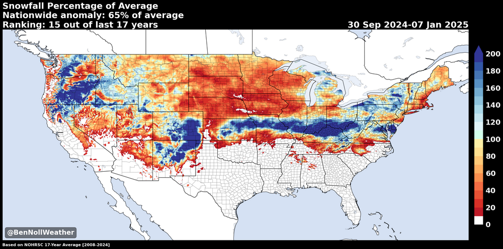
And the Midwest, northern plains, Rockies, and New England. Take a look at a current snow depth map for these areas…it’s unbelievably bad. The southern 3/4 of MN has bare ground, which is shocking for January 9th. Even northern MN only has 2-4” of snow cover, when they should have 12”+. Unfortunately, it has been a horrible winter for a lot of areas. Hopefully things change soon for all of us, as it’s really getting ridiculous. Speaking for my backyard, we haven’t had a good winter since 2014-15.
-
Would be a more meaningful graphic if it showed snow depth days (SDDs) instead. It would probably show even more of a deficit in a lot of areas. Many areas in the Midwest and northern plains actually have bare ground or very little snow cover right now, which is unbelievably sad for the time of year.
-
Way out there, of course...and it's only one Op run...but the 0z Euro brings down the motherload Nice temperature contrast too.
-
Yeah, 6" on 12/19.
-
And possibly most of MN, WI, SD, ND, and N IL too. It's shockingly horrible and ridiculous, not much else to say. As an example, Minneapolis only has 8" for the season and has had 0 snow depth since 12/28, with no snow in sight. They've only had 9 days of snow cover so far, wiped away by the Christmas week torch. Even INL only has 3" snow depth...just incredibly bad.
-
Spot on - you took the words right out of my mouth. Hopefully the 12z op Euro is an outlier, and the 12z EPS isn't trending this way.
-
Not to minimize that extreme event of course, but it would translate to approximately -35F on the new/current wind chill scale.
-
Good stuff. 1/20/1985 was Chicago’s all time coldest temperature, -27F.
-
My issue with chinooks is not so much how long the associated warm temps last. It’s that they even occur in the first place, especially during the heart of winter (12/15 to 2/15). Any day 40F and higher is too warm for me in winter, and we’ll probably have 5 consecutive 40+ days next week. Not easy to preserve snow cover and frozen lakes with temps like that. I’m a fan of having a part of winter that is sacred and untouchable, in other words it should feel like winter simply because of the calendar instead of having to hope for a certain pattern or teleconnection. In July/August, 95+% of days feel like summer here. Would be nice to have that same experience in winter, at least for a 4-6 week period.
-
Yeah, the "too far east trough" has really hurt the winter so far in much of the country...essentially anywhere east of the Rockies outside of the lake effect snow belts. That's a big chunk of real estate. The chinooks in MT/CO have been crazy. Denver is +7.6F above normal for Dec so far, even vs. the warmer 1991-2020 normals...and this will probably increase even more by month's end. This creates two problems: (1) the "angle of the cold" is all wrong, so we're left with generally windy and dry conditions (2) the western ridge is so far east that, when the trough relaxes/kicks out periodically, the warmth floods in quickly. That's what will happen during the next week starting around Christmas. We finally had a modest snow in our neck of the woods, and were looking forward to snow on the ground for our annual New Year's trip to central WI...but warm air will wipe out all the snow cover during the next week, even up around 44N and most of WI. Similar to the past 2 winters, the winter sports industry (mainly snowmobiling) is getting whacked up there again. Most years, they have a solid 3 months of reliable snow cover, from 12/15 to 3/15. Very unfortunate. We need to shake up the pattern, and hopefully the trough will be further west in early Jan. As of now, it looks somewhat promising...but still way out there in model land.
-
Winter 2024-25 Medium/Long Range Discussion
beavis1729 replied to michsnowfreak's topic in Lakes/Ohio Valley
Amazingly, ORD had 1,130 SDDs in 1978-79. Unbelievable winter. -
Winter 2024-25 Medium/Long Range Discussion
beavis1729 replied to michsnowfreak's topic in Lakes/Ohio Valley
Great story, and it’s what brings us all here. Hoping against all hope. -
Ding ding ding. This is the same issue in the Midwest/Plains/Great Lakes too. While one could say we've had a relatively chilly December (I say "relatively" since the 1991-2020 normals have warmed so much from 30-40 years ago, so you really need a -5F departure these days in Dec to be meaningful), only the downwind areas of the great lakes have seen any respectable snow this season. And when it warms up in between, even the lake snow melts except for far northern areas...so we're left with bare ground in the source regions...in which case any better/colder pattern which may come along in Jan can't maximize the cold. If it's not one thing, it's another. This pattern would be fine later in the season if there were already widespread snow on the ground, as it would help preserve snow cover and reinforce cold temps. But not in Nov/early Dec - just bad timing.
-
Winter 2024-25 Medium/Long Range Discussion
beavis1729 replied to michsnowfreak's topic in Lakes/Ohio Valley
Right...and of course it's not meant to be personal. But while relentless optimism is probably a good thing overall in life, it sometimes comes across insensitive and out of touch…as it invalidates others’ concerns and valid points. After 8 bad winters in a row, there are reasons to be frustrated, right? Of course, you’re not responsible for making others feel better on a wx board…but there’s another dynamic going on here. People like us who enjoy deep cold, snow, and everything about winter (which presumably includes you too!) don’t get any sympathy from the public. So, we often come here for that, as everyone likes to feel part of a group with shared interests. So, your comment about a possible 1-2” of snow on the solstice is tone deaf, since (even if it actually occurs) it will be gone by Christmas…with a torch possible for the last week of 2024. In all of your comments, there's an underlying tone of "why are you complaining?" But many of us look at it differently, i.e., who cares about 1-2” on the solstice in this setting, given how bad Dec has been up to this point and is expected to be post-Christmas. And when you keep saying that December has been chilly up to this point, many folks have two issues with that: (1) There’s hardly any snow cover in the Midwest, Plains, and GL…much less in our back yards…so who cares about the relative cold (2) ORD’s normal temps are about 5F (!) higher for 1991-2020 vs. 1951-1980…so it’s all relative. A normal DJF in 1951-1980 would be ok, but a normal DJF today is way too warm. In other words, you need a -5F departure month to be decent these days. Unfortunately, after struggling with it for years and years, I’ve finally had to acknowledge that our winter climo is horrible. I guess I have you to thank for this, so congratulations. I've been denying it for so long, but have to admit that you’re right. What capped it off for me is looking at Snow Depth Days (SDDs), where you add up each day’s snow depth in inches across the whole season. It’s a great way to compare the severity of winters, as it combines snow, temps, and snow cover into one easy number. After doing this, the 1976-1985 period sticks out like a sore thumb to periods before and after. This is horrible for me to accept, as I grew up on winters during that time and therefore it became my expectation. But even so, people are still going to wish for “better than normal” on a wx board. So, it’s annoying to constantly be told that these wishes are not logical…even though it may technically be true. I hear this from the public all the time, so we don’t need to keep hearing it on a wx board full of our fellow weenies. Yes, we know our climo is horrible…and, no, we don’t want to keep hearing about it. Chicago annual average SDDs (winters ending in the years noted) 1966-1975: 162 1976-1985: 343 1986-1995: 113 1996-2005: 187 2006-2015: 225 2016-2024: 130 Even though the 2006-2015 winters look relatively good in the above chart, they weren’t really that good in my mind. So now I need to accept that, compared to the last 8 winters, those winters were like living in Siberia. Definitely not an easy pill to swallow. As an example, for two of these winters in particular: 2008-09: Many people think this was a great winter…but there was no snow cover at ORD from 12/27 to 1/9, then the wintry feel essentially ended after 2/8. You need to have snow on the ground for most/all of Dec 15th – Feb 15th in order to have a proper winter. Doesn’t need to be a lot of snow cover, just 3” so that blades of grass aren’t showing. 2010-11: Even with the GHD storm, there were significant periods of no snow cover (such as 12/31 to 1/11, right in the heart of winter)…and we couldn’t even hold on to the GHD snow cover beyond 2/17. When you get that much snow at the beginning of Feb, it should stay on the ground through the end of the month. If it were Nov or March, that’s different. Just too many thaws. As always, our issue isn’t snow – it’s temps. If we had a reliable 30-50” of seasonal snow with average temps 5-8F colder than our current norms, we’d be in good shape. That’s why the warming of DJF normal temps by 5F over the past 40 years is so devastating. Every degree matters in this area. We don’t need blizzards and subzero temps – but the thaws are just too much to overcome. Thaws need to have temps in the 30s, not 40s and 50s. Even this morning was frustrating. We finally got a dusting of snow, but it didn’t stick on the pavement, and will probably melt today in the sun despite the somewhat chilly temps. Snow isn't supposed to melt in the sun on 12/18. It’s like everything is going against maintaining a proper winter vibe around here. That’s why you need to build a base in the first 2 weeks of December…since dustings of snow would then be welcomed and not worried about, since they just refresh the existing snow cover. When you keep starting from scratch on snow cover over and over again, a million variables need to go right to get things going. It’s just exhausting. Winter shouldn’t just be “cooler than July with occasional periods of snow and cold”…as if getting a couple of decent snow events in DJF is a win. But that’s how low our expectations have sunk. It’s not about individual “events”; it’s the feel of the whole winter. That’s like saying our expectation for summer should only be “milder than January with occasional warm days”…which of course isn’t true. No one in their right mind would be happy with that in summer. -
Winter 2024-25 Medium/Long Range Discussion
beavis1729 replied to michsnowfreak's topic in Lakes/Ohio Valley
“Thank you, sir, for only punching me in the face instead of kicking me in the ****!” Not that it matters, but ORD is much worse than DTW. Zero days of 1” snow cover.


