beavis1729
-
Posts
2,571 -
Joined
-
Last visited
Content Type
Profiles
Blogs
Forums
American Weather
Media Demo
Store
Gallery
Everything posted by beavis1729
-
Winter 2024-25 Medium/Long Range Discussion
beavis1729 replied to michsnowfreak's topic in Lakes/Ohio Valley
“Thank you, sir, for only punching me in the face instead of kicking me in the ****!” Not that it matters, but ORD is much worse than DTW. Zero days of 1” snow cover. -
Right, and that was a great end of January...but then it was in the 40s two days after this with rain...and then winter essentially ended after that. And Dec 2018 was bad too. Everyone likes to point out wintry periods...but winter is 13 weeks, not 1-2 weeks. A good portion of the snowfall that winter was in Nov and Apr, which skewed the numbers since the snow wasn't in DJF and therefore didn't have any staying power. DJF only saw 28.6"...not horrible, but not great. And Dec only had 1.4", which is when you need to build the base for winter. That's why it's frustrating - like we work so hard to finally get a good wintry period in late January...then it lasts for 7-10 days...then it all blows up in 2 days. No one is expecting it to remain below zero of course, but the thaws should be 25-35F, not 40s with rain. Another annoying thing about that period - ORD's UHI only allowed for a min of -23F during that cold snap. The air mass was definitely there to challenge the all-time coldest -27F on 1/20/1985, which makes me think it will never be broken. ORD performs "best" on advective cold, which was the case on 1/30/2019...but then 1/31/2019 was more radiational cold.
-
SDDs are a seasonal metric - "snow depth days". You add each day's snow depth (in inches) for the whole season. It's a great way to compare the severity of winter seasons...as it combines temperature, snowfall, and snow cover/retention all in one metric.
-
Your response is logical, and of course appreciated. I know you’re coming from a good place. My point is that, when you love the beauty of winter and everything that goes along with it, it’s hard to deal with the trend of recent seasons. It’s like being a sports fan…there’s a lot of tradition, family, emotion, and deeper meaning to it all. It’s more than just the game itself. That’s how I feel about winter. Everyone else can have the other 9 months each year…but let winter be winter.
-
Agree, nice analysis. Hopefully this timing holds, and we can get some good upstream snow cover in advance of this. 2013-14 had it, but unfortunately snow cover across the lower 48 is currently anemic at best. While there have been cold shots, only the immediate lake belts have benefited…and even there, too many thaws to maintain the snow cover. Just seems extremely difficult to get a proper and truly wintry December east of the Rockies these days.
-
I was talking about Chicago. But the point still stands, as even your coldest Junes still had average daily mean temps in the upper 60s, which probably translates to highs in the upper 70s. That’s pretty warm to me.
-
Even if it has been cooler than recent torch Decembers, this isn't saying much. It's supposed to be cold in December; why is that such a big deal? Our coldest December 1-10 since 2010 - and what will we have to show for it for the rest of winter? Nothing. And a -5F departure vs. the 1991-2020 normals is not very impressive anyway, since the normals are so warm these days and keep getting worse over time. Also, it just shows how obscenely warm Decembers have been since 2010...but we're celebrating this?? And, even in this supposed "cold" December, there's very little meaningful snow cover in the lower 48. I guess one could blame the dry pattern due to the W ridge being too far east...but even if we would have had snow east of the Rockies during the "cold" Dec 1-10, it would melt by Dec. 20th in most places. The point is that a supposed "cold" pattern still leads to pitiful snow retention at the time when winter should be in full force due to short daylight, Christmas, etc. The point is that, no matter who argues with whom about 5,000,000 meaningless details, we can never seem to put together a decent stretch of winter in December, i.e., a "base" to set the tone fo rthe rest of the winter. Not saying we don't get cold periods sometimes...but they are interrupted by way too many thaws. You can't run a winter like that. Once a lake starts to freeze, it should freeze over - not this back and forth freezing and melting crap. It's not too much to ask for wintry conditions in a winter month, and our standards deserve to be higher. Who knew that December shouldn't be expected to be a wintry month anymore? That's what many seem to be implying on this board - it's a ridiculous notion full of denial and despair. Like the 5 stages of grief - we've just given up even when we deserve better. Is June not a summer month? Over the last 50 years, there have been 2 Junes which could be considered non-summery: 1992 and 2009. Ok, so 2 out of 50 years. That's how December should be - 48 out of every 50 should be wintry. This means highs 25-30 and lows in the teens, with building snowpack and ice beginning to form on lakes...and an occasional day of 40+. But people are now happy if half the days in December have sub-40 highs. Pretty soon, people will rationalize being thankful that December is cooler than July - hooray!!! P.S. Who cares about forecasting getting the pattern right. On a forum containing mostly winter weather enthusiasts, all that matters is whether a cold & snowy outcome prevails. SDDs are all that matters, not snow amounts. I think ORD has 3.1" of snow for the season, but most came in one day and it melted within 12-24 hours. But some use this as a way to say that "at least Chicago hasn't been shut out from snow, and it's not really as bad as some seasons up to this point". But that's nonsense - people expect you to be ok with 12-24 hours of modest snow cover as of 12/16, with very little hope in sight for the next 1-2 weeks? If someone could conduct an analysis showing the 10-year moving average of SDDs east of the Rockies since 1950, it would tell the story completely. Our winters are becoming a disaster, and no sugar-coating will help. No one is saying that *periods* of wintry weather aren't possible...but DJF is 13 weeks, not 2-4 weeks. Every single December, it's the same crap over and over again for the eastern 2/3 of the country...not just one localized region. It's ridiculous. Mods can move this to whatever banter/venting thread you want - doesn't matter anymore. And I know how people will respond - and the pre-emptive answer is "No, I shouldn't need to move to Fairbanks AK to experience winter." The only hope is for a change to the AMO cycle - but will that really matter? It's hard to be optimistic.
-
But "normal" is very mild these days, compared to 30-50 years ago. So a colder than normal December doesn't really mean much imo, unless the departure is -5 or more.
-
This is a great point, and often gets overlooked in these discussions. Another ridiculous stat on this: For the 1951-80 normals (which I grew up on), the normal low at ORD on 12/31 was 13F. For the 1991-2020 normals, it's 21F. So the normal low at ORD has increased by 8F in 40 years. People should be rioting, but everyone just says "whatever" and moves on like everything is ok. If ORD gets a winter month with a slight minus departure vs. the 1991-2020 normals, everyone says how "cold" it is...but such a month would be significantly above normal vs. 1951-80 normals. IMO, the worst outcome of the above is that everyone's standards have fallen so low. It's like we've all given up on anything good, so we ratlionalize it by having low expectations. Kind of like being a Bears fan. I saw a post in our sub-forum saying how great it was that 9 of the first 14 days in December 2024 had a high below 40F in Toledo...as if we should be excited about that. Really? It's annoying if any single day in Dec has a high over 40F, much less 5 of them. The days are shortest in Dec, so it should feel like it. Currier and Ives would be rolling in their grave. And while, technically, we can get a decent amount of snow in Jan north of 40N even with "mild" temps, we should expect more than that. Dec 15th - Feb 15th is the core of winter, so snow shouldn't be melting every day or two. Have our expectations really sunk that low? Most of us wouldn't be happy with cold temps in July, but we're suddenly ok with snow-melting temps in Jan? If we get slightly more snowfall than normal in Jan but it melts every few days, it's irrelevant. Yet another reason why total snowfall is misleading as a stat. We should be looking at SDDs, as it's a much better reflection of the tenor of a winter and would better exemplify the horrible winters we've seen since 2015-16 in the Midwest and Northeast. We aren't asking for Alaska or Siberia, just seasons in seasons. DJF should be winter, not an extended fall with a few weeks of occasional wintry weather here and there. Last winter was a great example of this IMBY. For 2 weeks in January, we had really great wintry conditions...but nothing for the rest of winter. Do we ever have summers where it only felt like summer for two weeks in July? It's maddening to have to expect a perfect pattern to get wintry weather during winter.
-
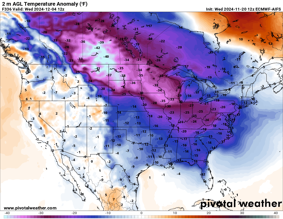
Yeah, very impressive. Of course it’s an operational run way out there, but here are the Day 14 temp departures.

-
Summer-Fall 2024 Weather Disco Med/Long Range
beavis1729 replied to John1122's topic in Tennessee Valley
Yeah, unfortunately today’s runs (including the 18z GFS) completely lost the -EPO that several runs over the past few days were showing. And it’s not like this was 2+ weeks out, it was roughly days 6-10. I guess this type of rug pull is tolerable for now, since it’s still mid-November. If this was 2-3 weeks from now, I would be furious.- 688 replies
-
- 1
-

-
- heat
- thunderstorms
- (and 7 more)
-
I'm expressing societal concerns - it's not about me.
-
Even though you said you're aware of the station location changing, it's a huge factor in why the winter temp has only risen 0.3F over the past 150 years in Chicago. A station right on the lake is always meaningfully warmer in the winter in this neck of the woods, so it's not a fair comparison to ORD. I find it funny that nearly 100% of the scientific community is concerned about the recent warming, and it's clear that the impact of UHI on temps (and exacerbating the impact of heat waves) is worsening...yet I'm the one who is out of line in my comments? All I'm doing is summarizing the consensus and concerns. Of course temps have been warmer in Earth's history, but it's the rate of warming recently which has been shocking. Places in the arctic have warmed 5+ degrees over the past 100 years. The lower 48 hasn't warmed as much, but still a material change. How could one argue that this isn't something to be mindful of? As mentioned before, I actually do believe/hope the recent warming is somewhat driven by seasonal/decadal factors...but until we see how the next 10-20 years shake out, shouldn't we have a heightened level of concern? It's just solid proactive risk mitigation. I also happen to believe that we have a lot of other environmental issues on Earth which are much more concerning than climate change...but that's for another discussion. I know you may not mean this...but some people on this board come across as not being worried at all, and even dismissive of anyone who simply voices the consensus. That's strange to me...but I suppose it's in line with the individualistic U.S. mindset/approach on all issues, i.e., "me, me, me...who cares about how things may impact anyone else." Edit to add: here's a clear illustration of the worsening impact of UHI during heat waves. For August 26-27, the AM lows at ORD were 79, 78...compared to 72, 74 at RFD and 75, 75 at MLI. The air mass was essentially the same in both places. One could even argue it was more humid at MLI, yet even so the AM lows at ORD were 3-4F higher. Besides the obvious frustration about human/industrialization impacts on local climate, the lack of nighttime cooling has been documented as a significant concern re: modern heat waves in urban areas.
- 231 replies
-
- 1
-

-
- absolute trainwreck?
- abandon all hope?
- (and 1 more)
-
I think people are getting caught up on the semantics of the word "historical". To me, historical doesn't mean the same as unprecedented. Yes, it has been hot this time of year in the past, and yes it has hit 100 in Sept before. But normal highs are near 80 this time of year, so the 96 & 99 highs at ORD yesterday & today respectively (combined with very high humidity, dews mid-upper 70s) are an extremely unusual occurrence in late August. Why is this controversial? It's just like in winter, when people use basic high-level numbers to judge how good a month or season is. There is much more to it than that. For example, if January has 10" of snow but with snow cover all month due to cold temps, it's definitely more wintry than a January with 15" of snow with constant thaws. The point is that total snowfall doesn't tell the whole story of a winter. Same idea in summer - the past 2 days at ORD had extremely high humidity with very high overnight mins. This is much worse from a historical/impact perspective than a 102/65 max/min with dews around 60. In other words, high temps alone don't tell the whole story. The Climate Changer is correct that things have been warming up recently, especially in UHI areas. Of course, this is in general...not necessarily every single year. And, of course, we can't attribute individual heat waves to this. But people have a right to worry about more heat waves, especially if you live in a city with worsening UHI and the public planning/actions aren't helping to mitigate UHI (much less acknowledge that it's a problem to begin with). I guess we have know-it-alls on this forum who go against all of the established science. For what purpose - to stir up drama? Why? Recent warming is common knowledge, even if it's not 100% man-made. Pointing this out shouldn't be controversial. Look at the average temps at ORD as an example; they've increased 3-4 F over the past 40 years in winter, and 2-3F in the other seasons. That's a very big deal. Heck, even a 1F change would be a big deal over 40 years, which is a speck of time in the grand scheme of things. It's even worse in the arctic. Perhaps The Climate Changer and others get frustrated sometimes because no one (meaning "global society") seems to acknowledge it, or care, or do anything about it. It's the same idea as a person who works tirelessly to advocate for affordable housing and other policies to help the homeless...but nothing ever gets better because not enough people in important/influential positions care. Whether it's UHI worsening, higher nighttime mins (not as much daytime maxes), more impact in the winter vs. summer, or a combination of all of these...it's definitely happening. Personally, I'm putting my hope on a reversing AMO to slow or even reverse the warming a bit...which will be great if it happens. But even so, it's reasonable to take an approach of "I'll believe it when I see it". There are going to be deaths from the current heat wave, especially in Chicago due to less access to AC and other reasons. That in and of itself makes it a noteworthy and concerning (one could even say "historical") event, unless we don't care about people suffering. None of these comments are meant to be alarmist; it's just the unfortunate reality. Why is it nonsense for The Climate Changer to point these things out? If people don't want to accept the factual/statistical info, you can put him on ignore.
- 231 replies
-
- 6
-

-
-
-

-
- absolute trainwreck?
- abandon all hope?
- (and 1 more)
-
Bayfield and the Apostle Islands are a beautiful area…love it up there. Hope you have a good time even with the iffy weather.
-
Texas 2024 Discussion/Observations
beavis1729 replied to Stx_Thunder's topic in Central/Western States
Falfurrias TX was 101/82/128 this afternoon. -
Texas 2024 Discussion/Observations
beavis1729 replied to Stx_Thunder's topic in Central/Western States
I suppose...but this early in the season? Any Heat Index above 95F is horrible imo, so yes I'm biased. -
Texas 2024 Discussion/Observations
beavis1729 replied to Stx_Thunder's topic in Central/Western States
And it's even worse today. Brownsville is 102/80/124, and McAllen is 107/74/121...just unbearable. -
Texas 2024 Discussion/Observations
beavis1729 replied to Stx_Thunder's topic in Central/Western States
McAllen TX was 103/77/120 yesterday...that's absurd for any time of the year, but especially so in early May. -
Vegas was 90/16/84 yesterday, RH 7%. And even that's nothing, especially in June when the heat really kicks in but it's still before monsoon season. It's not uncommon to see June afternoons around 100/5/92, RH 3%. At 3PM on 7/2/2007, it was 110/-7/99, RH 1%...just insanely dry.
-
Impressive late-season cold, especially by recent standards. It was 30 here. Some low temps in the LOT area: ARR 24 RFD 26 (record is 24 in 1988) DKB 28 FEP 28 DPA 29
-
Alaska/Western Canada obs and discussion
beavis1729 replied to patrick7032's topic in Central/Western States
Yeah, I've seen SDDs mentioned fairly often, but mainly in places where there's a reliable snow cover each year. I like it because it brings a lot of important variables together (temperature, cloudiness, snowfall, frequency of thaws) and is a great way to capture the overall tenor of a winter. If one cares about living in a wintry place, it's probably the best/simplest metric to compare winters from one locale to another. Simply using snowfall as a winter metric can be very misleading. I'd much prefer a frontloaded winter with 40" of snow and a -10F temp departure, vs. a winter with 60" of snow and a +5 temp departure. The former would have a lot more SDDs. -
Alaska/Western Canada obs and discussion
beavis1729 replied to patrick7032's topic in Central/Western States
Another nice winter in southern Alaska. Anchorage just had their 2nd snowiest winter on record (132.6"). Average is 77", and the record is 134.5" set in 2011-12. Even more impressive is the snow depth days (SDDs) and # of days with snow cover. I'm not sure what those records are for Anchorage, but the final 2023-24 numbers have got to be close...and possibly brand new records: - 3,965 SDDs (the record snow season of 2011-12 had 3,807 SDDs) - 174 days of 1+" snow cover, including 172 consecutive days - 170 days of 6+" snow cover...more than 5.5 months! - 152 days of 12"+ snow cover - Peak snow depth of 38" on 2/5 (record snow depth is 47" on 1/1/1956) - Still 20" snow depth on 4/14, and 10" on 4/21 Warmer temps are on tap, which should allow for a quick snowmelt. Normals for April 15th are still fairly chilly (45/30), but high temps will probably soar well into the 50s later this week. *Edit #1: First 50F of the season on 4/20; the first 50F temp in Anchorage since 10/2/23 (201 days ago) *Edit #2: Updated stats through 4/24/24 -
Late Feb/March Medium/Long Range Discussion
beavis1729 replied to WinterWxLuvr's topic in Mid Atlantic
Not intending to speak for weather will, but there is probably a reverse psychology component to this. I can relate to it, since unfortunately I do it too. In the northern suburbs of Chicago, we have had 9 consecutive bad winters. 2013-14 was good, 2014-15 was decent (can’t call it good since the first half of winter was almost non-existent that season). The 9 since have been bad, using more meaningful metrics like SDDs (as opposed to snowfall totals). If snow melts after a few days, it ruins the ambience and tenor of winter. After so many years of being let down, one stops getting excited about winter overall (and snowstorms that show up on models) because it has often resulted in being let down. But in March, you feel more open to being excited, since it’s out of the “expected” season so you have less to lose if the threat falls apart. So, I don’t think it’s trolling. It also bothers me when people talk about climo all the time, and keeping expectations in check. If that were really true, there’s really no use getting excited about winter. There are certain absolute standards for winter. If you live in Miami, 1976-77 was a cold winter relative to normal. Does that mean it should get an A grade? Of course not, since there was never snow on the ground. Bing Crosby didn’t sing “I’m dreaming of a white Christmas…with the caveat and hope that all of the atmospheric indices line up perfectly.” I just want symmetry in the seasons. If you wake up in the heart of winter, it should be reliably cold with snow on the ground. When I look out the window in July, I know it’s going to feel and look like summer. There are no worries. I think a lot of us just want winter to be more consistent and reliable. It doesn’t mean there haven’t been wintry periods IMBY over the past 9 years…but there is no consistency. In late January 2019, we had two mornings in the -20s with nearly a foot of snow on the ground, but then it was in the 40s two days later. That’s unacceptable. Cold snaps seem to flip quickly, instead of more gradual warm ups on the back end of them. End of rant - all of this to say that, for people who really love the tenor of winter and like the harmony of seasons in seasons, it has been a very difficult period. The worst part about this winter is that, even in places where I thought winter was always sacred (like 45N and north in the Midwest), it has been horrendous. I had two snowmobiling trips planned in northern WI, and both were canceled. In fact, many areas never opened trails at all! Usually the season is from 12/15 to 3/15. It’s just horrible. Many areas in far northern WI average near 100”, but have only had 20” this season. Parts of MN have had less than 10” for the season. Obviously I don’t live in your forum area, but I stop by here often for the quality of discussion (same with TN valley). The lakes/Ohio valley forum seems puritanical, like you’re not allowed to be excited about snow and cold. Just wanted to add some context to the frustration and conversation. I hate to admit it, but it seems like we need to wait for the AMO and PDO to flip, in order to even have a reasonable chance at a decent winter. I realize this is a pessimistic view, but unfortunately it seems like a reasonable approach after 9 consecutive warm/bad years. -
Make that 77F at Rockford - just ridiculous. Normal high is 38F.