
Mikeymac5306
-
Posts
956 -
Joined
-
Last visited
Content Type
Profiles
Blogs
Forums
American Weather
Media Demo
Store
Gallery
Everything posted by Mikeymac5306
-

E PA/NJ/DE Winter 2024/25 Obs/Discussion
Mikeymac5306 replied to JTA66's topic in Philadelphia Region
Seen more snow today than in the last 2 years! 32 and covering the outdoor tabletop. -
-
E PA/NJ/DE Winter 2024/25 Obs/Discussion
Mikeymac5306 replied to JTA66's topic in Philadelphia Region
1994 was probably the worst winter I ever experienced. I'll never forget 19 degrees and heavy rain. LOL Skating rinks for weeks. I remember seeing the salt trucks going backwards for miles cause they had no traction to drive forward to lay salt down. One good thing was my Dad worked for the electric company. Our power was only off for a few hours, and we had a pretty nice vacation that summer. lol. -
E PA/NJ/DE Winter 2024/25 Obs/Discussion
Mikeymac5306 replied to JTA66's topic in Philadelphia Region
Had some sleet at the start last night which quickly turned to rain in Exton. Long range has some mood flakes Saturday while all the local Fire Departments make thier santa runs. Fantasy land looks like we keep a side eye on NYE, but even that doesn't look promising this far out. -
We take...

- 1,105 replies
-
- 1
-

-
- tropics
- heavy rainfall
- (and 5 more)
-
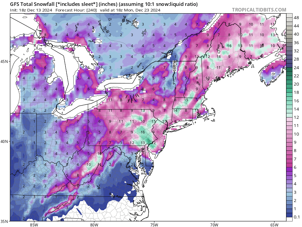
Interesting run on the 12z. Would certainly avoid Torchmas this year.
-
Only good thing about the 94 ice storm was that my dad worked for the electric company. We had one hell of a summer vacation that year!
-
Come 20 miles west and it's a Festivus miracle!
-
Euro trying to give us a Festivus miracle. GFS says nope!
- 1,105 replies
-
- 1
-

-
- tropics
- heavy rainfall
- (and 5 more)
-
Wet roads here in West Chester 37 degrees.
-
Talking about postponing it. No reason to have it if no one can get to the stadium.
-
White rain all day here in Exton. Temps have dropped a bit to 35 degrees.
-
Welcome back snow birds! Happy snow hunting this year!
-
Drove through it on my way home from upstate yesterday. Could see the smoke from Wilkes Barre. It laid down in the valley on the other side of the tunnel which made it look like a foggy day. Saw the smoke as far south as Quakertown exit.
-
Delaware has them as well.
-
Had just enough drops to wipe them off my windshield. 59 degrees. Never thought I would pray for a hurricane to be a drought buster but man the GFS looks sexy this morning... or maybe it's just a mirage since it's so far out still, and we are in a new desert.
-
Mets/Padres would be entertaining as hell if you follow baseball! The casual fan wouldn't care.
-
So THAT'S how the Government controls the hurricanes....
-
I say it all the time. Weather wise, we are damn lucky to live where we do. We don't get the blunt force trauma from an approaching hurricane. We get a rare blizzard, or strong EF3+ tornado. Any major storm damage is mitigated in a few days for the most part. Don't get me wrong we have had our fair share of bad weather too but it's less frequent than other areas.
-
Anyone know what that bright thing is coming through the clouds in West Chester?
-
Yeah really looking forward to some cool weekend nights at the firepit... Oh. Rain next two weekends.
- 1,105 replies
-
- 1
-

-
- tropics
- heavy rainfall
- (and 5 more)
-
Given recent history I am not expecting anything big.
-
No... No we don't. While I don't enjoy the humidity that sets in with August. I do enjoy the longer days.
-
Looks to me Debby is gonna get through the area little faster than first thought. Weekend looks beautiful!
-
I'm just hoping for light rain at this point. I'll be camping in Richmond for NASCAR.