

Carvers Gap
-
Posts
17,430 -
Joined
-
Last visited
Content Type
Profiles
Blogs
Forums
American Weather
Media Demo
Store
Gallery
Everything posted by Carvers Gap
-
If you really want to see how complex the pattern is about to get, go to the NH view of the 18z GFS and look at it at 500. Once the Aleutian high(edit) is dislodged, chaos ensues. Model mayhem is likely on the table at this point. To me, I would suggest the potential for a progressive(but slow) pattern. Versus things getting locked in, we may well see things move...but slowly until things shake out. What is on modeling is a major disruption to the atmospheric circulation. I think we are about to see an amplified, short wavelength pattern. It is almost like the big Aleutian high was a cotter pin - kind of held things in place.
-
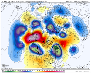
The 18z GFS may be right after Jan 5th, but that is a bizarre run with not a ton of support from other modeling. Looks like feedback problems to me yet again. Let's see if its ensemble supports that. I will say....the BIG problem is that we have 7-8 vortices rotating counter clockwise around those AN heights that was dislodged from the Aleutians. If you go to the northern hemisphere view, you can see them orbiting in what looks like drones just circling a mother ship. Models are not handling that well at all, and understandably so. Below is the Euro at 12z at hour 216. Amazing, but good luck to numerical model sorting this out any time soon!!!! ....To all the models at 0z, may the odds be ever in your favor.
-
I doubt it. Definitely on the sauce at 12z. LOL. I was getting ready to bust on it until I stumbled across this in my search. This is its look for Dec 29 to Jan 5. Yes, first part of that is going to be warm but the time from from Jan 3-5 could be very cold. But look at the date this was made....
-
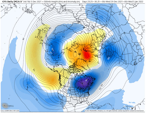
@Holston_River_Rambler...always great photos Not sure I have ever seen something like this before. This is the 12z CFSv2 control. These are -20F departures for western portions of the forum area......for a 30 day time frame. LOL. The mean is 5-10 BN which is just insane in an of itself. This is why I don't share a foxhole with this model...but, man.
-
Jax, if the SST build in the western Pacific, that would likely allow more convection to occur in the MJO regions 8-1-2, right?
-
LOL. Check out these 24 hour temperature changes from Jan 2 to 3. First is the CMC and the next is the Euro. The CMC is at 6z on the 3rd and Euro is at 12z on the 3rd. GFS is a mere 25-30 degree temp change.
-
After the weather we are having right now, if we go BN for part of early January that is gonna hurt! Just sayin.........
-
We really need a "wow" like button for this site. That is crazy. Are we talking the GOA or Aleutians when talking eastern Pac? I would think a more traditional placement would be likely. EPS was playing with that late in its run...either that or zonal with some northwest flow.
-
The 12z EPS has the period of Jan 3-10 BN for temps, and that is with a warm-up embedded. Both the GEPS and GEFS reflect a similar depiction. Precip during that timeframe looks at or above normal if smoothed. Could be a warm-up and rain deal, could be over-running, could be a slider....lots on the table. Looks like we have a cold shot around the 3rd, cold relaxes, and another (maybe more significant) shot arrives around the 7th. The EPS tries to lift the BN heights at 500 northward, but the cold(mslp maps reference) is so extensive it almost has to burn itself out.
-
The 12z EPS is a pretty much a complete reversal of the current pattern at almost all latitudes of NA, just flip the reds and blues at 500. Oh the irony if we switch to a +PNA pattern. Most of those flips are good...but not all.
-
12z EPS looks good. Not sure what is going on with the GFS operational...but all three ensembles show a nice period of cold weather for early January. Whew - the CFSv2 is really cold. Probably is not right for a number of reasons(little to quick with the MJO and it is always cold anyway), but crazy in terms of eastern cold. The ensembles look like a scaled back version both in intensity and duration.
-
I like your ENSO thread, especially during the off-season. I think you should keep it. Both threads(severe/ENSO) are kind of unique to our subforum. Your call, but just my two cents.
-
Euro looks more like the CMC though not to that extreme for the Jan 3 front. Looks like a wave rides the front w/ some winter potential north of I40.
-
12z CMC and GEFS look similar to previous runs, including the cold shot on the 3rd.
-
Most modeling has been very solid with the Jan 3rd cold front - Jan 1-2 have been warm(just not record warm). There is a cool front that comes through on some modeling around NYE or NYD. Looks to me like the GFS still had a good run and a pattern flip. Just giving it a closer look, looks like both the CMC and GFS get to a cold pattern with the same mechanics which is to use a piece of energy to rotate cold in behind it. The GFS is jumping on the second piece of the split trough. CMC deepened the eastern trough with the first piece. So, not sure that was an MJO issue as much as it was with model jumped on which piece of energy to slam the cold home. For now, my money is on the CMC.
-
The difference in the 12z CMC and GFS on the 3rd is stark - stark. The CMC is single digits shortly after and the GFS seems to be struggling with feedback over the eastern PAC. It could be right, but it doesn’t have support to this point. Again, its MJO looks nothing like the others. The CMC has been super consistent. We will se what the Euro does at 12z.
-
MJO for the gfs looked off this AM. May be right and it may not. We are going to see some runs today which are likely vastly different between model suites. I take some comfort in that the GFS continually busted on going into 8. LOL. So it’s jog back towards 6 is an outlier among models at this time. CMC at 12z looks good. Gfs will get there but later in the run.
-
18z CMC looks equally cold through Jan4th...and I am going to bed! LOL.
-
0z GFS commentary: -Cold from for Jan 3 is 10-15F below normal. -Temps go below freezing on the 3rd. Many places north I40 are not depicted to get back above freezing until the 5h. -Would appear the GFS is again feeding back with a split trough where the western portion gets cut-off. Could happen, but not sure -Temps over the East are BN to much BN through he 6th. -Impressive cold shot. Take a look at the mslp maps vs 500. You can see the cold underneath those ridges at 500 while looking at those surface maps. Crazy. -EPO ridge(albeit displace westerly a bit) goes into the Arctic. Bout it. Cold looking run from the 3rd onward to the 8th, brief interlude of warm, and appears another cold shot inbound after a cutter. -Possible feedback error with the slp that drifts off the coast of California after 340.
-
Thanks a ton!!!!
-
For those who enjoy reading Webber(I am included). Thanks to the MA forum for this share:
-
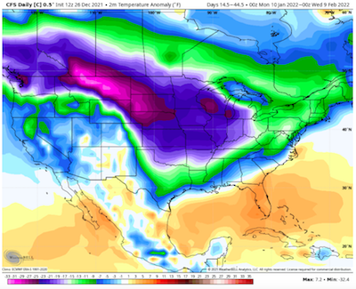
18z GEFS has turned sharply colder in the LR. Fairly unusual to see an ensemble which is -10F below normal at this range, especially in such a widespread fashion. Keep in mind those departures are during the coldest part of the year. Time will tell if these trends are indeed real. I would suspect that moderates during ensuing runs as extremes rarely verify. Seasonal will work along with( and this is important) an active STJ. That might be one of the coldest runs I have seen from the GEFS in regards to the entire continent nearly being BN for temps. @Holston_River_Rambler, can you GIF that just for posterity? Again, unlikely that verifies to that extreme, but would be interesting just to keep as a reference. Specifically, the daily temp anomalies for North America.....
-
This may just be a case of climatology taking over(January is our coldest month). We don't need as many things to be exactly right in order to get cold. We'll see. See all of those AN heights at 500 and so much cold at the surface is counterintuitive. So, wary I am.
-
@tnweathernut, looks like the first significant disruption of the AH begins around Dec 30/31 if modeling is indeed correct - between 120-130h. Looks like a couple of storms crash into it. Almost immediately after that, the area of hp loses its uniformity and lifts out over the next few days. And you are on the money about whether this is correct or not...just tough to know. I think this scenario very possible, but not ready to take the step and say it is likely. 18z GFS again with another flip of the pattern. Agree also it could be rushing, but other modeling seems to be there with it. What is crazy on this run is that NA gets so cold that the AN heights at 500 are still cold at the surface and the BN heights are even colder at the surface. What looks warm is just "less cold" air getting moved around. Not sure I have seen that on a map in a long time. At the end of the run, there is this big ridge in the central US....generally below normal at the surface with another shot of cold incoming.
-
Will just use this post(update as the run progresses) to cut down on tons of posts for the rest of the 18z run: -Hudson Bay high will drive this pattern for the rest of the way along with what would seem a very -AO. -By 288 the big red blob over the Pac is adios'd -The Hudson Bay high will force the storm track well south if real. This would be an Atlantic dominated pattern if real. Check that...AO dominated pattern and a HB high dominated pattern. -Europe has turned sharply colder by 288 which tele connects well to cold temps over the EC. -1068 high coming down out of Canada around 300. Super smiler to both the Euro and CMC which had monster highs coming down. -Fairly massive Arctic outbreak being modeled after 300. -This is 2020 February 2.0 light...yikes -Pretty epic run as at one point roughly 1/3 of the US (mid and upper Plains, Rockies) are below zero.


