

cbmclean
-
Posts
3,314 -
Joined
-
Last visited
Content Type
Profiles
Blogs
Forums
American Weather
Media Demo
Store
Gallery
Everything posted by cbmclean
-
Marked this post in my mind when we have our postmortem at the end.
-
PSU (or anyone else interested in answering) I have been studying 500 HP trying to understand the correlation between them and surface temperatures. With a simple west ridge/east trough, it is very simple to see how the airflow brings cold air down from the norther latitudes and cools us down. But for something like the ridge bridge depicted above I have trouble visualizing how the gph anomalies lead to the conus getting flooded with cold air. Any wisdom to share?
-
I know, I was just laughing at the wording.
-
Man, you know the pattern is bad when you have to worry about insolation overhead at night. Fromthe RAH AFD (Long Range). Above normal temperatures will continue through much of the period, especially during the overnight hours thanks to plentiful insolation remaining overhead.
-
Wow, a +38 °F anomaly. That is something special right there.
-
Did you mean p2/p13?
-
As I was joking about up in your thread, we are more disturbed by the 12z op than we are enthused by the 12z gefs. We are like beaten dogs.
-
We would be excited but we are too busy jumping off the cliff due to the 12z GFS.
-
I freely admit to being one of the spook-ees I did not fully comprehend the nature of the duration caveat. I though the pattern was such that when it reached full development, it always stuck around. Although in my defense, that post did have a pre-post which advertised it as " the least popular post in americanwx history. "
-
I was out of circulation on the GEFS the last few days, other than what people were posting. Did it fully cave?
-
I prefer that way to the alternative where I am loosing sleep because I'm emotionally disturbed by the torch. Realistically, not a good look for the SE for frozen, but I will take dry cold shots over Pacific Doom Blob any day.
-
Was it 2010? I remember a year around then when the NAO/AO was so persistently in our favor that it kept funneling warm air up in eastern Canada while I had record cold. Not sure what was happening in NW Canada at that time. I think that was like the grand finale of good AO/NAO blocking it has been almost universally crappy since then (with a few exceptions).
-
A cold Canada may or may not have any impact here. I mean I like seeing it just because I like the inherent idea of cold anywhere, but there have been winters where the cold stayed completely bottled up in there. I haven't seen any evidence of the MJO going into the cold phases. Both the GEFS and EPS seem to have it headed to the COD, which is certainly better than currently, but not particularly good.
-
Wasn't there a guy here who lived in that far south corner. That map must make him physically ill.
-
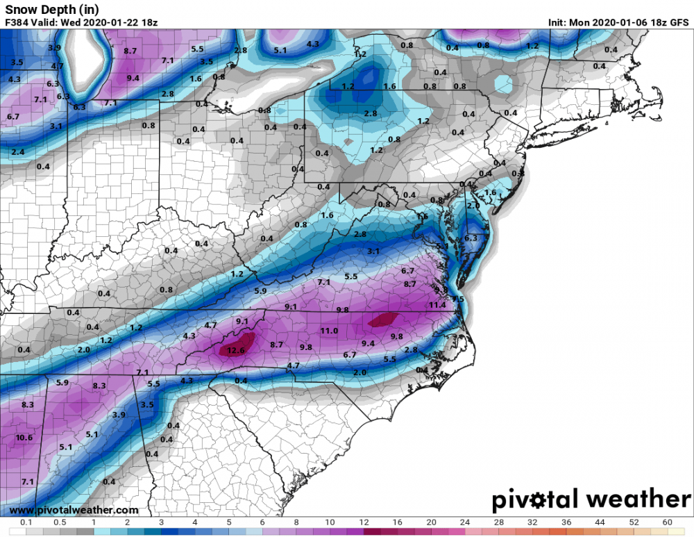
If you compare this pic from C.A.P.E with the same time stamp from Pivotal (posted by SteveRDU in the SE forum), you can really see the effect of the sites' different algorithms for snow accumulation. I live just slightly southwest of the "9.8" in eastern NC. WeatherBell shows me with zilch, Pivotal shows me with 7 inches. Even setting aside the long-lead clown map aspect of both of them without knowing anything else, I can tell you that WeatherBell is much more realistic (or rather less unrealistic). Makes me wonder how Pivotal could have such crappy algorithms or how they could be that different from each other.
-
Yes I misunderstood this caveat. I was under the impression that you had found that once the Pacific Doom Blob came to play it, always stayed long term.
-
Yeah, I'm a realist about my climo. Although I love snow, I will happily take mild/wet/cold/dry cycles as opposed to endless SER warmth. I could even hope for nice little- EPO cold snap
-
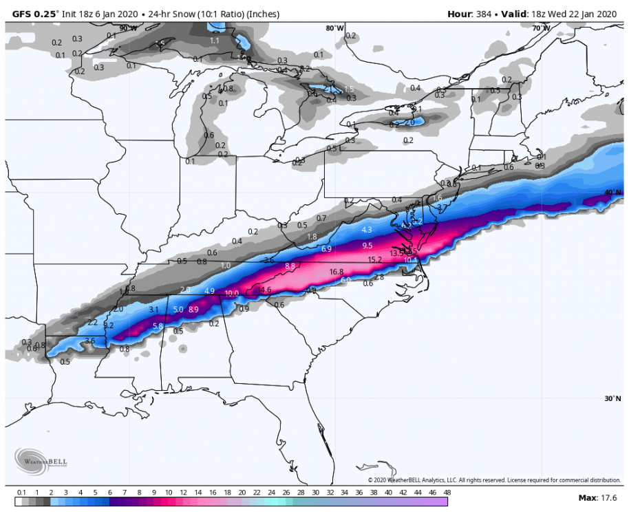
I was just about to make a funny post saying not to look at the 384 hour GFS if you didn't want to see another I40/85 N special but too late. One odd thing though C.A.P.E posted a map of the same model run at the same 384 hour time stamp but it was from WeatherBell. It had a much less of the good stuff south of 40/85. Wonder what the difference is.
-
Hey CR, can you lower the snow shields and raise the SE Ridge shields for a change?
-
I am infinitely happier having the EPS on my side and the GEFS on a bad island rather than the usual reverse situation, but I am having a hard time intellectually accepting the hope. I can't see the d10 - 15 EPS, but I haven't heard anyone mention a good NAO look so I am assuming it is so-so at best. PSU's research showed that the ONLY way out of this mess was NAO help, so without that I just can't see us climbing out of this hole. Nothing else was able to turn the trick. If the snow-happy 50's and 60's couldn't figure out a way to escape (other than with the NAO) I can't envision us pulling it off today. I will happily be wrong.
-
Watch this be the time where the GEFS gets its revenge and crushes the EPS.
-
Whoops: neophyte mistake.
-
Well he mentioned the North Atlantic trough specifically, that was what I thought he was talking about.
-
How does that work to help the E Conus?
-
Very informative, thanks.


