cbmclean
-
Posts
3,327 -
Joined
-
Last visited
Content Type
Profiles
Blogs
Forums
American Weather
Media Demo
Store
Gallery
Everything posted by cbmclean
-
Why does convection there feed the central pacific ridge?
-
Thanks Don. I am curious, do you feel it is likely that the ++++AO is linked to the central pacific ridge, or is it just bad timing of two unfavorable features. I mean I know that everything is connected on some level in weather I am just curious if they are just two manifestations of the same underlying phenomenon.
-
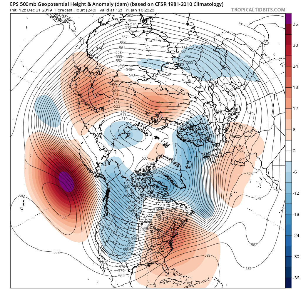
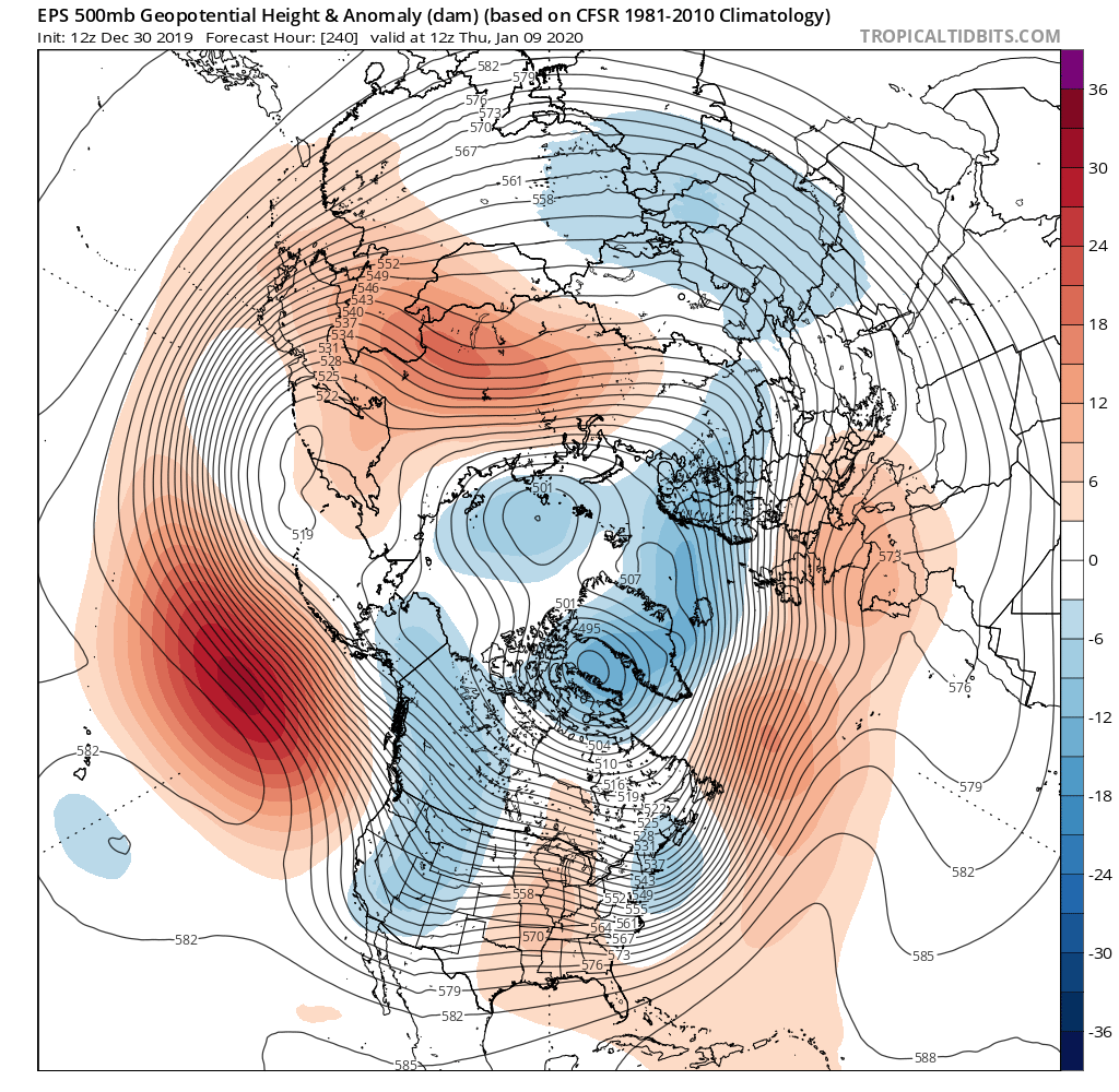
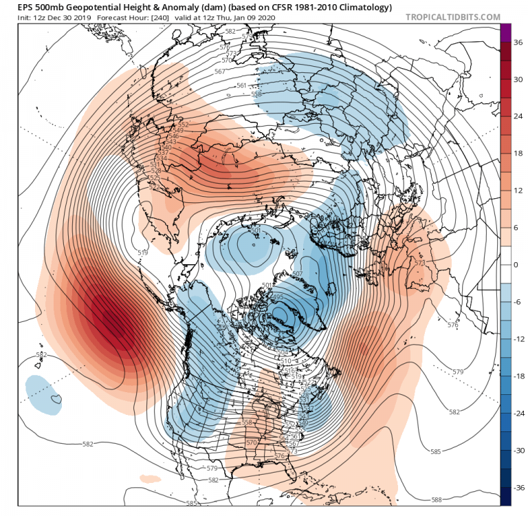
I took the day off. Just looked at the 240 Hr EPS. Pacific Doom Blob even stronger.

-
Over the years you have been one of those leading the way for castigating the GFS for its fantasy snow storms and cold. I think most of us have just learned our lesson.
-
No.
-
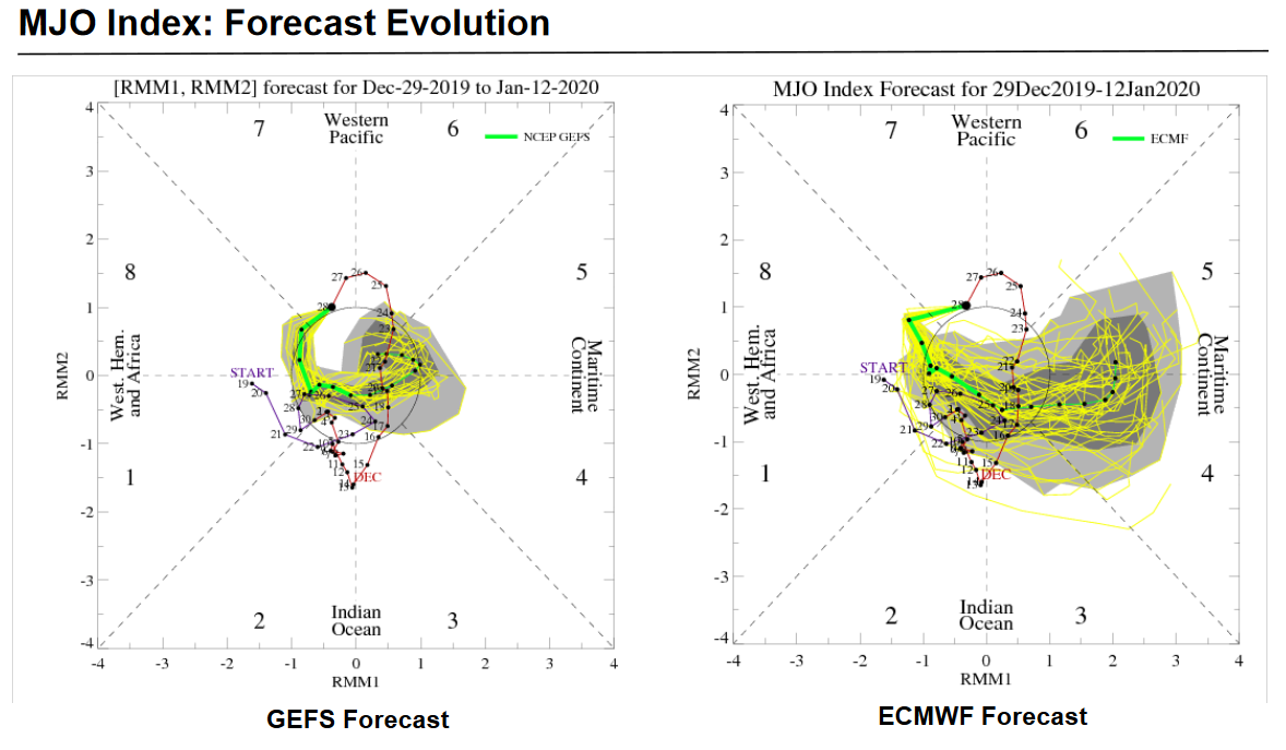
Link to the weekly MJO write-up from the CPC. Nothing surprising. Need to root for the GEFS (I hate saying that). EPS takes it absolutely apesh!t into the bad phases. Jeeze where have I seen that before. https://www.cpc.ncep.noaa.gov/products/precip/CWlink/MJO/mjoupdate.pdf

-
Well, the talk of the expanding Pacific warm pool skewing the MJO to the warm phases has me spooked. But enough about that in this thread.
-
I think the NAM is synonymous with the AO.
-
To be frank I think it is completely rational to be concerned that we may be on the brink of the start of a 100 year stretch, for reasons that I know you know, but I will not mention in this thread. On the other hand, I think it is not unreasonable to hope that the recent decadal wasteland of +NAO/AO may be unrelated to that dark force that we will not name and perhaps soon we will see the return to better NAO/AO behavior.
-
Alright, that wins the thread.
-
I'll just leave this here. Sleep tight.
-
I think he did. Ji's posts are emotional outbursts of frustration. The recent PSU post is just data. Cold, hard data. It can't be bargained with, it can't be reasoned with, and it absolutely will not stop until we are all curled up in a ball in our bedrooms with the blinds closed and clutching an old farmers almanac.
-
I for one am proud that I had a hand in inspiring PSU to create this masterpiece. I think this may set a record for most crushed hopes and dreams by one post. I noticed in the stat pool that this nightmare actually repeated in THREE CONSECUTIVE YEARS: 1989 - 1991. Can you imagine what would happen to this forum if that stretch were to recur? Actually, that gives me a sliver of hope. We have been at a place approximately this bad before, once for three straight years. So maybe we can recover from this in future years.
-
@PSUHoffman I seem to remember you debating this with someone last year. Seems like their argument was that it was physically impossible to get significant -EPO and significant -NAO at the same time. You retorted that it was indeed possible and pointed to a specific time frame. Can you remember any instances of this? I think some may call it a "ridge bridge".
-
I think this map is just comparing the Ensemble Mean temp forecast between the 12Z and the 0Z. It doesn't actually show the forecast anomalies.
-
I think I will try to at least get through tomorrow without peeking.
-
I really should but I know I don't have the will-power. I also want to follow the Day 7 - 9 cool shot to see if it can at least throw you guys a bone.
-
Well, according to PSU's analysis, once that ridge show up, it stays all winter (yuck). Apparently the one and only way to avoid the doom is to have a stout -NAO. Since the weeklies are seeing the TPV hovering over the NAO area the whole period, it is therefore bound to predict hot garbage. So our only hope is simply that an unanticipated NAO pops up at some point. It is just that simple. I think Bob was saying that we did have a brief period of NAO blocking pop up in the medium range right around the beginning of the Pac puke, so maybe it can happen again.
-
Nose of doom pattern just starting to peak into under 10 days on the EPS. Maybe one day we'll have a really good pattern show up at d15 and inexorably march forward in time.
-
On the other hand, I have also seen some speculate that decreasing temp gradients between the tropics and polar regions should lead to a weakening in the polar jet. I would assume that would mean more time in the -AO mode. Sure aren't seeing it this winter though.
-
I saw this article earlier, maybe on this site last winter. It chilled me to the bone. Imagine in the future, 9 out of 10 years with never-ending Pac puke.
-
I think you may have posted this before, but how many years were in your analog pool for Pacific Doom Blob? Apparently there at least a few where the blob died earlier than others? I know I'm reaching for straws here, but not much else to do.
-
Sorry, the "it" I was referring to was the Pacific Doom Blob.
-
If you cycle through the GEFS to the very end, if you squint real hard you might be able to see it weakening and slowly migrating east. TPV is absolutely nailed to Baffin Bay.
-
I can't wait for it to start doing curley-cues