

cbmclean
-
Posts
3,342 -
Joined
-
Last visited
Content Type
Profiles
Blogs
Forums
American Weather
Media Demo
Store
Gallery
Everything posted by cbmclean
-
Question for anyone. How does confluence impact geopotential height?
-
bootleg snowflakes.
-
Bootleg.
-
So is there some sort of inter-seasonal memory? I had never heard that.
-
They lost contact. The whole country was crushed under the weight of that ginormous high.
-
Actually there were widespread snow flurries in NC on Christmas day as a result of the forcing from that Mega-front. I saw some in Old Fort NC (just east of Asheville) and my parents saw some in Hope Mills (just southwest of Fayetteville). Of course, nothing stuck but it was still nice to see on Christmas.
-
Third straight year of torch for the first 1/3 to 1/2 of January. It's becoming a New Year's tradition.
-
Which three are those? I assume you include the NAO and AO. What is the third? PNA or EPO? I am assuming PNA because the EPO looked stuck positive for the foreseeable future when last I saw a few days ago.
-
The blocking could disappear leaving only the positive anomalies.
-
I almost feel that the thread was too positive this afternoon. Time for the 0Z runs to ruin it.
-
Someone posted a twitter link where Ji had posted the first comment. I clicked on his name and went to his twitter feed. That is not what I expected Ji to look like. It did amuse me that his handle is "jhatem". https://twitter.com/jhatem
-
-
I like that little tiny cool anomaly over the UP of Michigan. They are going to get their snow regardless.
-
Well luckily, one of these seems to be on tap. It's a crap shoot as to whether it will help or not. But it seems to be coming, nonetheless.
-
No, If we are screwed, I would prefer to know it ahead of time, so I appreciated it. It was still sad, though. Speaking of Mersky, I haven't seen him around lately.
-
I am not disputing your larger point about the danger of the Pacific Doom Blob (it still haunts my dreams from last year). You have mentioned our unfortunate antecedent conditions. Maybe this look CAN produce, but only if it is not preceded by a month-long continent-wide torch? It would be interesting to go back and look at the preceding month or two before the snow periods of 1993, 1996, and 2010.
-
My soul still has the wrinkle marks from where it was crushed by that post.
-
Last sustained cold to affect me was late December 2017/early January 2018. That was a legit cold period here, and I think up you guys way as well. Not sure where it's source was. Also, there was a pretty nice outbreak that hit the Midwest in Jan 2019, but never made it here.
-
You have mentioned that you don't feel as if super cold cross-polar flow is in the cards this year. What is your feeling about the feasibility of simply getting the Pacific to be mediocre enough to not overpower perfect NAO blocking?
-
I don't post many maps. I am actually a novice myself, but I love to learn. Yes on those 500 MB maps the AN anomalies are various shades of red.
-
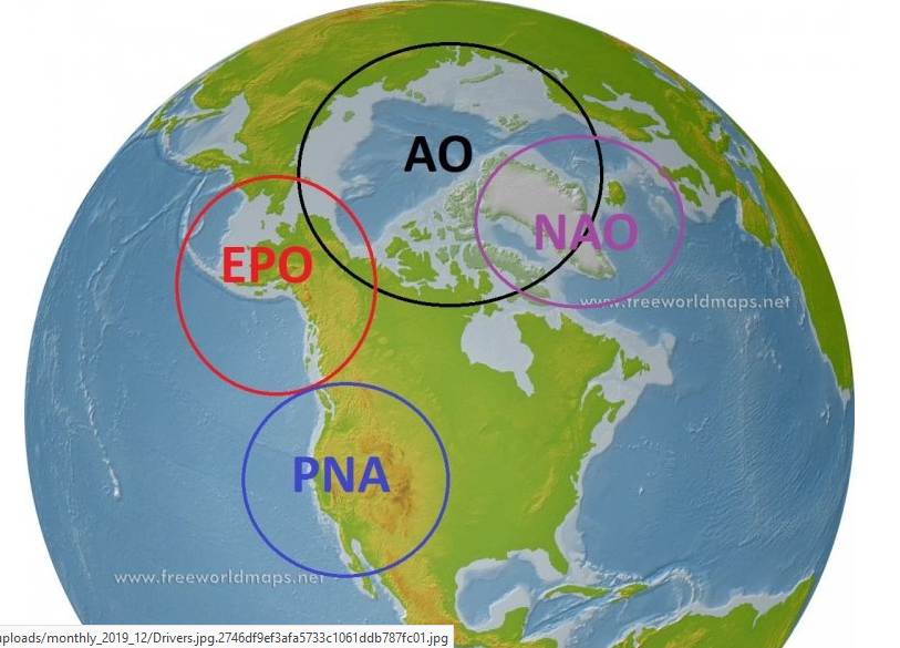
I stole this graphic from the post that PSU made to start off the snow climo thread last year. He has marked the EPO domain. An EPO ridge is just AN 500 MB heights in the EPO region.
-
Thank you very much, GEOS5ftw, this is exactly the additional details that I have been looking for. I am intensely interested in learning more about this. If I was looking to invest some hobby money into technician literature about this topic, is there a term for this sub-specialty of meteorology? I don't mean modeling. I mean understanding why air masses obtain the temperature characteristics that they do, and how the get moved to different locations. For example, what made the Feb 1899 airmass so cold in its source region, and how did it get unleashed into the lower 48 with so little attenuation?
-
I assumed North Balti Zen was being tongue-in-cheek. It was made abundantly clear that PSU did not consider that outcome to be likely.
-
No, Jacksonville does see a few flakes once a decade or so, more like Miami.
-
I actually despise working from home. I am unable to do half of what I need to, and the half I can technically do online is much less efficient because of network issues and difficulties in communicating with coworkers. I go in as often as possible.


