cbmclean
-
Posts
3,342 -
Joined
-
Last visited
Content Type
Profiles
Blogs
Forums
American Weather
Media Demo
Store
Gallery
Everything posted by cbmclean
-
I have been lurking here for years and I do not think it is fair to characterize PSUHoffman as Doom and Gloom. He describes what he analyzes in the models, independent of his personal desires. Right now, the long term (past day 10) looks very grim. I understand that you believe that the models have no use past day 10, but we do not all agree.
-
That's right my precious, spend as little time as possible in the good phases, and at as low an amplitude as possible. Then rocket into the COD and exit in the bad phases again.
-
GEFS and GEPS show identical crap ridges in the east at 384. So that makes all three major ensembles giving us the finger at that time frame.
-
I can agree with that.
-
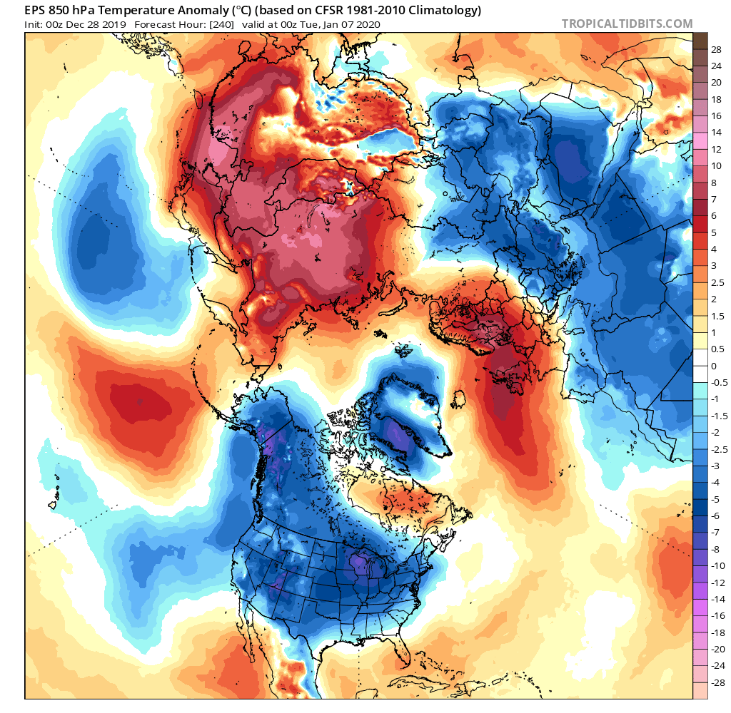
Right now, latest GEFS shows return to cool anomalies in the east around 228. GEPS a little slower at 234 or so. I can't see 2m EPS anomalies on TT, but at 850, cool anomalies in place by 216.
-
That is true. I don't think anyone who is responsible will claim to "know". But right now it appears that the preponderance of the evidence favors a higher probability of the Pacific being hostile for the long term.
-
Relying on the NAO is a scary place to be this decade.
-
Looks coolish, not necessarily cold. Which to be frank, is a still win for me. I love snow, but if I can't have it, I will take cool and dry. I hate winter torches.
-
EPS leading the way is infinitely more encouraging than GEFS
-
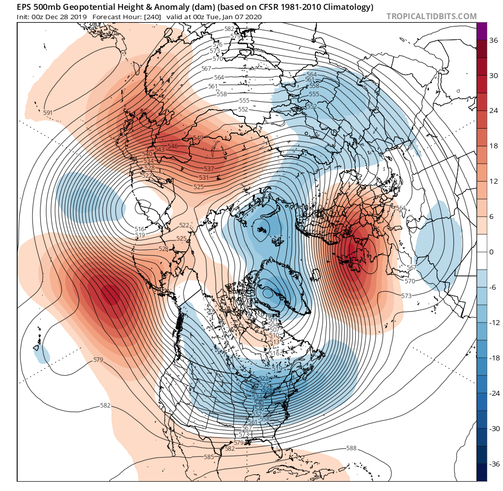
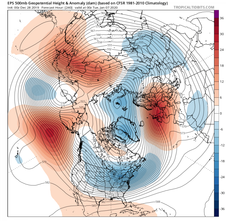
If I understand correctly, a vaguely -EPO type look on the 0z EPS at 240. Impressive extent for 850 negative anomalies, although centered towards the western Great lakes, with very muted anomalies in my neck of the woods. Somewhat better for you guys, but still too far west for our tastes. Probably dry though? Sad +NAO as usual.

-
Based on all the information you have at your disposal, together with your years of experience, what is your conclusion about the probability of the Doom pattern verifying at approximately the level of doom being depicted now? For example, in the CPC long 1 - 7 and 8 - 14 day out looks, they assign a measure of confidence ranging from 1 - 5 based on numerous factors
-
Looking at tropical tidbits, I only see the EPS out to 240. But I saw on Wikipedia that it goes out to 15 days, and I think I have seen others discuss the bad pattern showign up in the EPS post-240. Does TT only have access to truncated amounts of EPS data?
-
Thanks. The TT color scheme makes it much less obvious. I was also expecting a tighter gradient.
-
As I mentioned I am embarking on the process of trying to seriously lead to read the charts. I was looking at the 12z EPS at 240 and could not see a TPV at all. Am I missing it? Got a new tablet and I haven't yet figured how to copy and paste images or I would share it.I By the way what site do you use for model output?
-
I was thinking that the ice would still be much thinner than normal there and thus subject to higher heat flux from the water. Apparently not enough to maintain a ridge.
-
Summary of MA thread feeling for today: Apocalyptically bad pattern incoming. Not only is it horrible, it is the kind of pattern which tends to get dug in for months at a time. Strong Objective-based evidence for fearing for all of January.
-
So are we heading to what they would classify as an Arctic Low?
-
Actually I am looking forward to our annual March -NAO outbreak which gets us flurries.
-
Very quick summary of MA forum discussion today: For the foreseeable future pretty much zero chance of SE snow (outside of high terrain). Fairly decent shot of a cool/dry shot or two. In the very long range, models currently advertising a George Costanza pattern (ie the exact opposite of everything that is desirable).
-
Yes that is very helpful thanks. Wouldn't it be nice if that anomalous warm bubble actually verified a couple of thousand miles east but was still as persistent?
-
I finally have time to start seriously learning how to interpret 500 HP charts. Before you take your break, can you explain the negative downstream effects of the ridge north of Hawaii?
-
PV bouncing around in all the wrong places?
-
Man look at that triangle of doom in West Kansas.
-
Won't gave access to the models for a bit. GEP look good?
-
Gotta love how it shows sleet/zr in the gulf of Mexico. 1899 redux. I'm sure it will happen.