jm1220
Members-
Posts
26,026 -
Joined
-
Last visited
Content Type
Profiles
Blogs
Forums
American Weather
Media Demo
Store
Gallery
Everything posted by jm1220
-
OBS-Nowcast for snow 4P Tue 2/11-7A THURSDAY 2/13/25 Mainly NJ-NYC-LI.
jm1220 replied to wdrag's topic in New York City Metro
It's the 700mb fronto band that very often develops in these storms. Someone up there might end up with a few inches.- 338 replies
-
OBS-Nowcast for snow 4P Tue 2/11-7A THURSDAY 2/13/25 Mainly NJ-NYC-LI.
jm1220 replied to wdrag's topic in New York City Metro
0.9" now, snowing at decent clip. For those bellyaching about the Nam, the best banding looks north of me if anything.- 338 replies
-
- 1
-

-
OBS-Nowcast for snow 4P Tue 2/11-7A THURSDAY 2/13/25 Mainly NJ-NYC-LI.
jm1220 replied to wdrag's topic in New York City Metro
And if there's snow falling in the LHV it will be wrong since it had zero there.- 338 replies
-
- 2
-

-
OBS-Nowcast for snow 4P Tue 2/11-7A THURSDAY 2/13/25 Mainly NJ-NYC-LI.
jm1220 replied to wdrag's topic in New York City Metro
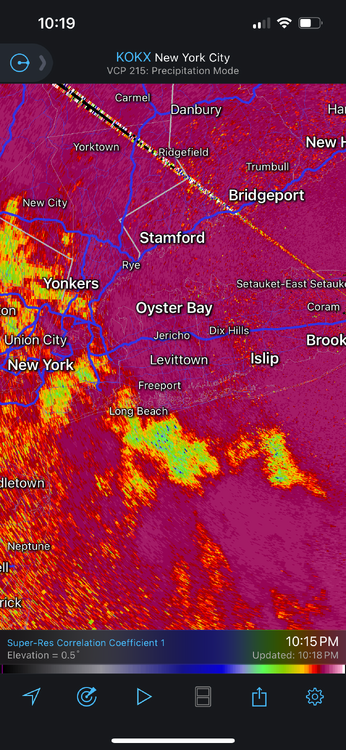
If you look at the radar over E PA there is snow starting up over the Poconos down to I-78. It won't be heavy but it's headed ENE and should clip most of the LHV.- 338 replies
-
- 1
-

-
OBS-Nowcast for snow 4P Tue 2/11-7A THURSDAY 2/13/25 Mainly NJ-NYC-LI.
jm1220 replied to wdrag's topic in New York City Metro
Snow firing up in E PA. We'll have to watch to see if it congeals into a heavier snow band or stays light, and how far N it expands. Most models at least have some getting into the lower Hudson Valley. If we have snow in NYC/I-80/LI until 8 or 9z, or until 3am we can still have a couple or few inches.- 338 replies
-
- 2
-

-
OBS-Nowcast for snow 4P Tue 2/11-7A THURSDAY 2/13/25 Mainly NJ-NYC-LI.
jm1220 replied to wdrag's topic in New York City Metro
Yep, nice big flakes. Almost 0.5" here.- 338 replies
-
OBS-Nowcast for snow 4P Tue 2/11-7A THURSDAY 2/13/25 Mainly NJ-NYC-LI.
jm1220 replied to wdrag's topic in New York City Metro
Good coating here, light snow.- 338 replies
-
- 1
-

-
Can we keep it on topic? There’s a banter thread for other things. Hoping for a positive bust, outside chance at 3-4” if that northern fronto band develops with Atlantic inflow.
-
There’s often a heavy snow band that develops on the north side of these in the 700mb fronto max zone, and usually has high ratios. NAM still looks the most impressive in developing that frontogenesis zone and moving it across NYC/LI.
-
If we have dewpoints in the 40s that will melt most of the snow. High dewpoints air=snow killer. But tonight we cheer, 1-3” will be nice.
-
15" in Huntington Station.
-
Wed into Thu if the NAM is right might be mostly a sleetfest just away from the coast, cold surface air looks pretty stout. If we have a decent snowpack, sleet is good to mix into it to give it staying power. It’ll freeze it into cement.
-
Awesome how the sleet raises a fist and gets knocked down for NW Suffolk and N Shore. Still a pelting here, some rain mixed in but heavier is sleet.
-
The heavy rates bailed us out. If only the temp here could be 2 degrees colder but still 2” so far.


