

jm1220
-
Posts
26,172 -
Joined
-
Last visited
Content Type
Profiles
Blogs
Forums
American Weather
Media Demo
Store
Gallery
Everything posted by jm1220
-
January 28/29 Blizzard Observations/Discussion/Nowcasting
jm1220 replied to Northof78's topic in New York City Metro
It would’ve helped NYC and NJ most likely and the upper lows developing better would’ve pushed the heavy snow further west. -
January 28/29 Blizzard Observations/Discussion/Nowcasting
jm1220 replied to Northof78's topic in New York City Metro
Yes they did-the convection really did mess the storm up somewhat. -
January 28/29 Blizzard Observations/Discussion/Nowcasting
jm1220 replied to Northof78's topic in New York City Metro
Nice! Congrats. Very rare that your area does so well in these storms. -
January 28/29 Blizzard Observations/Discussion/Nowcasting
jm1220 replied to Northof78's topic in New York City Metro
Absolutely. And when does that area ever get near jackpot totals? I have no idea what I ended up with really in Long Beach due to all the drifting. I'm estimating 12-13" but it's really a guess. My place in Huntington Station was probably 16". Nice sunset! -
January 28/29 Blizzard Observations/Discussion/Nowcasting
jm1220 replied to Northof78's topic in New York City Metro
Yeah, the short range models especially did good picking up on that enhancement. -
January 28/29 Blizzard Observations/Discussion/Nowcasting
jm1220 replied to Northof78's topic in New York City Metro
Wish I could’ve been in this 3-4 hours ago. Easily 1-2”/hr again in this. -
January 28/29 Blizzard Observations/Discussion/Nowcasting
jm1220 replied to Northof78's topic in New York City Metro
Logan Airport-BOS 14.5" at 1pm. They'll likely make it to 24". Awesome storm for them. -
January 28/29 Blizzard Observations/Discussion/Nowcasting
jm1220 replied to Northof78's topic in New York City Metro
Side of the house. This was as the snow started ramping back up. Just about SN+ again. Winds died down a little which are probably helping with the flake size.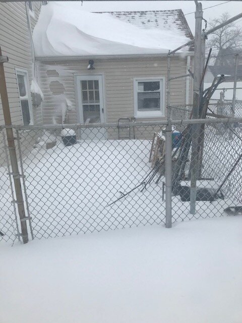
-
January 28/29 Blizzard Observations/Discussion/Nowcasting
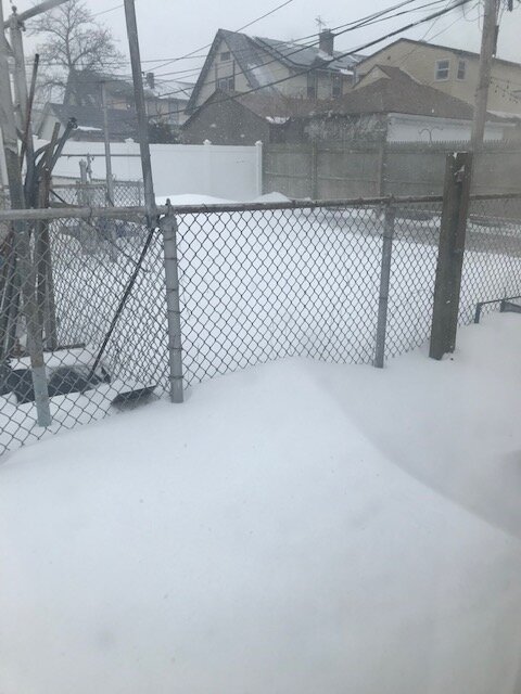
jm1220 replied to Northof78's topic in New York City Metro
Outside my front window a few minutes ago.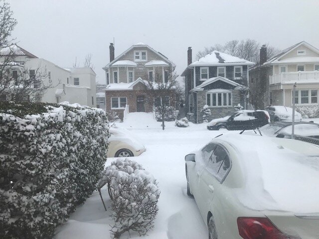
-
January 28/29 Blizzard Observations/Discussion/Nowcasting
jm1220 replied to Northof78's topic in New York City Metro
The sound is helping enhance the snow. Essentially-fast winds over the sound with little friction meets land with more friction, air has to slow down and rise. And it adds a little moisture as well. -
January 28/29 Blizzard Observations/Discussion/Nowcasting
jm1220 replied to Northof78's topic in New York City Metro
If I had to make a wild guess I’d say 12-13”. But the front of the house has little snow from blowing and the back has drifts a few feet tall or more. -
January 28/29 Blizzard Observations/Discussion/Nowcasting
jm1220 replied to Northof78's topic in New York City Metro
Snow definitely picking up again and finally bigger flakes. -
January 28/29 Blizzard Observations/Discussion/Nowcasting
jm1220 replied to Northof78's topic in New York City Metro
The sound is definitely helping to fire up the snow again. Easy to tell. -
January 28/29 Blizzard Observations/Discussion/Nowcasting
jm1220 replied to Northof78's topic in New York City Metro
Looks like straight 10-1 ratio. Once again shows you can’t rely on temps alone to create good ratios. One of my issues today has also been lousy snow growth/tiny flakes. -
January 28/29 Blizzard Observations/Discussion/Nowcasting
jm1220 replied to Northof78's topic in New York City Metro
Damn. The South Shore from Bellmore east will likely all finish with 20+. That area going to town again. I’m probably moderate intensity again, hopefully I can get one more heavy burst. -
January 28/29 Blizzard Observations/Discussion/Nowcasting
jm1220 replied to Northof78's topic in New York City Metro
Maybe a convergence area off the sound as well. That seems to happen with these storms. -
January 28/29 Blizzard Observations/Discussion/Nowcasting
jm1220 replied to Northof78's topic in New York City Metro
Long Beach. Basically I’m free snow shoveling labor for my mother. Snow picking back up, one last hurrah maybe. Hopefully we can get another inch. -
January 28/29 Blizzard Observations/Discussion/Nowcasting
jm1220 replied to Northof78's topic in New York City Metro
Should've stayed in Huntington. I have plenty here but I'm sure there's 4-5" more there. I've been battling subsidence here for a while. About as typical of these in Long Beach as the sun rising every day. -
January 28/29 Blizzard Observations/Discussion/Nowcasting
jm1220 replied to Northof78's topic in New York City Metro
22” at ISP, 2” last hour. Holy…. Whats ISP’s all time record? -
January 28/29 Blizzard Observations/Discussion/Nowcasting
jm1220 replied to Northof78's topic in New York City Metro
Lindenhurst to Melville must be getting smoked. My lord. -
January 28/29 Blizzard Observations/Discussion/Nowcasting
jm1220 replied to Northof78's topic in New York City Metro
My house in Huntington looks to be getting pounded. Light to moderate here in this semi-subsidence area. I have no idea really how much I have due to blowing but has to be over a foot. Probably 1-3” more to go for most of us. -
January 28/29 Blizzard Observations/Discussion/Nowcasting
jm1220 replied to Northof78's topic in New York City Metro
Out my front window in Long Beach about a half hour ago. Coming down heavy in this attempt at a band here.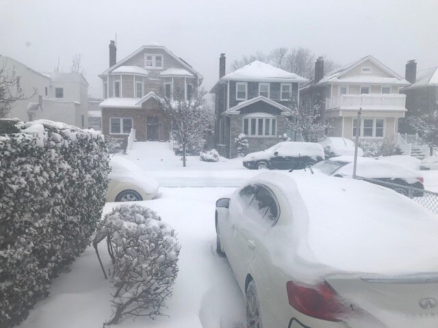
-
January 28/29 Blizzard Observations/Discussion/Nowcasting
jm1220 replied to Northof78's topic in New York City Metro
Central/northern NJ in for another burst as well it seems. Not the crazy LI stuff but enough for a couple-few more inches there hopefully. -
January 28/29 Blizzard Observations/Discussion/Nowcasting
jm1220 replied to Northof78's topic in New York City Metro
Rt 111 Smithtown to Islip getting wrecked. -
January 28/29 Blizzard Observations/Discussion/Nowcasting
jm1220 replied to Northof78's topic in New York City Metro
Radar looks amazing out by you. Awesome! Band really trying to pull together for Nassau. C’mon!!

