

jm1220
-
Posts
26,172 -
Joined
-
Last visited
Content Type
Profiles
Blogs
Forums
American Weather
Media Demo
Store
Gallery
Everything posted by jm1220
-
GFS is interesting but as others pointed out likely too suppressed. These storms highly favor I-90. Hopefully we pick up a few hours of heavy snow to start on the front end but unless there’s a major change in the evolution it looks like a fairly typical SWFE heading into a strong high to me. Thankfully at this point the warm ocean isn’t the kiss of death near the coast it would be in December so hopefully most of the storm wouldn’t be a washout.
-
Decent burst here a couple minutes ago. Too warm for any to stick however. Hopefully some of these squalls make it here later.
-
2/13 Light/Moderate Snowfall Nowcasting & Observations
jm1220 replied to Northof78's topic in New York City Metro
I gave into that, my bad. -
2/13 Light/Moderate Snowfall Nowcasting & Observations
jm1220 replied to Northof78's topic in New York City Metro
One last band developing over NJ? Could at least give another coating now that the sun is down especially. Just starting to stick on pavement here but now it’s just flurries. -
2/13 Light/Moderate Snowfall Nowcasting & Observations
jm1220 replied to Northof78's topic in New York City Metro
If that's the case then probably. We lucked out down here a lot more than I thought, seriously would've been near a warning event if it was a few degrees colder. I definitely admit I was wrong thinking this would be a bust. You called the better than models showed event! Maybe one more burst coming up from Monmouth, fingers crossed lol. Flurries now. -
2/13 Light/Moderate Snowfall Nowcasting & Observations
jm1220 replied to Northof78's topic in New York City Metro
If I managed 3" here on the barrier island south shore I'm sure Central Park where it was actually colder had 3-4". -
2/13 Light/Moderate Snowfall Nowcasting & Observations
jm1220 replied to Northof78's topic in New York City Metro
Down to 31 here, maybe we can really start to accumulate soon if it can keep up. This would be an easy 5” if it was 29-30 instead. But this is a great winter reminder/mood snow event and no shoveling lol. -
2/13 Light/Moderate Snowfall Nowcasting & Observations
jm1220 replied to Northof78's topic in New York City Metro
Up to just about 3” in Long Beach with another moderate burst now (still nothing on pavement). Very pleasantly surprised by this, I was almost certain this would be a bust. -
2/13 Light/Moderate Snowfall Nowcasting & Observations
jm1220 replied to Northof78's topic in New York City Metro
Yeah. Coming down hard here on the south shore but barely accumulating. I’ll be back after the super bowl, it’ll be a nice sight. -
2/13 Light/Moderate Snowfall Nowcasting & Observations
jm1220 replied to Northof78's topic in New York City Metro
Wow, heavy snow now. If only it was 30 instead of 32-33. -
2/13 Light/Moderate Snowfall Nowcasting & Observations
jm1220 replied to Northof78's topic in New York City Metro
Long Beach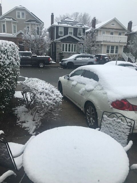
-
2/13 Light/Moderate Snowfall Nowcasting & Observations
jm1220 replied to Northof78's topic in New York City Metro
Almost heavy snow in this burst. Maybe we can make it to 3” here. Still decent stuff coming to LI for the next few hours. -
2/13 Light/Moderate Snowfall Nowcasting & Observations
jm1220 replied to Northof78's topic in New York City Metro
I gladly eat crow. Wish I was at my place on the north shore though, sounds like double what I have in Long Beach there. -
2/13 Light/Moderate Snowfall Nowcasting & Observations
jm1220 replied to Northof78's topic in New York City Metro
2” in Long Beach, cold surfaces only. I gladly eat crow for the city. Nice event-second snowy Super Bowl in a row! Snow picking up again with this batch coming in. -
2/13 Light/Moderate Snowfall Nowcasting & Observations
jm1220 replied to Northof78's topic in New York City Metro
Has nothing to do with the low track, it's still a sheared out POS in general. It's about where the frontogenesis banding we're seeing set up now ends up and pivots as well as how fast the cold can get in. There are some good jet dynamics coming in to help out the banding/lifting (part of the sheared POS evolution as it won't collaborate with the well out to sea low) but I have a winners/losers sense of how this turns out not to mention the 60F most of us saw today which means light rates will stick to cold surfaces only when air temps are 32 or over. Heavy rates will help drop the temps too. Hopefully this time tomorrow after the Bengals pull off the win we all have a wintry outcome. But many setups like this fail especially near the city. -
2/13 Light/Moderate Snowfall Nowcasting & Observations
jm1220 replied to Northof78's topic in New York City Metro
Where the fronto band happens will determine who gets the car topper and who can score a few inches or a lucky 5-6. HRRR insists it's west of 95 over NJ, other models have it over NYC and LI. We'll see soon what's right. -
2/13 Light/Moderate Snowfall Nowcasting & Observations
jm1220 replied to Northof78's topic in New York City Metro
It could happen if moderate to heavy snow can train over the city for sure, but the short range models seem to be focusing west of I-95 for that where it’ll also be a few degrees colder. Snow maps show what they do but don’t be too disappointed if they don’t pan out for the city and where I am in Long Beach. My house in Huntington Station where it’ll be colder might get the few inches for sure. I want the good surprise as much as anyone but I’m just never big on these wait on the cold air to come in for a weak system like this. -
2/13 Light/Moderate Snowfall Nowcasting & Observations
jm1220 replied to Northof78's topic in New York City Metro
Hard for me to think of any recent event where we’re waiting as temps are in the 40s (60 today) for it to cool enough as precip is starting up for good snow accumulation especially in the city. Hopefully this is the needle in the haystack where it’s wrong. -
2/13 Light/Moderate Snowfall Nowcasting & Observations
jm1220 replied to Northof78's topic in New York City Metro
If most in NYC somehow get 2” from this I’d consider it a huge win. My thought for NYC is car topper to the 2” in Bayside/Whitestone. -
2/13 Light/Moderate Snowfall Nowcasting & Observations
jm1220 replied to Northof78's topic in New York City Metro
Wow, pretty aggressive. Hope it’s right. -
2/13 Light/Moderate Snowfall Nowcasting & Observations
jm1220 replied to Northof78's topic in New York City Metro
Where I am in Long Beach and for the city I’m not expecting much accums wise, would be surprised to have more than 1-2”. Temps seem borderline as much of the snow is falling. 32-33 with light snow won’t cut it outside of car tops and grass and even that might be only when it comes down moderate. But the north shore and places where it can cool off to 30 can do a good bit better. N NJ where models are focusing on more might get a few inches. -
2/13 Light/Moderate Snowfall Nowcasting & Observations
jm1220 replied to Northof78's topic in New York City Metro
Not a fan of how it’s favoring NJ more and more but they deserve a nice snow event. Hopefully this can work areawide. -
2/13 Light/Moderate Snowfall Nowcasting & Observations
jm1220 replied to Northof78's topic in New York City Metro
If the snow is falling moderate or better and temp is 32, the warm ground won’t matter and snow will stick. I’m thinking 1-3” for most of us but could be a surprise 4-5” if the fronto banding shown on the HRRR especially does work out. All in all a perfect example of this season of a system that will deliver in a way but a few minor tweaks could have been much better. -
Sea breeze today here on LI. Mid to upper 40s on the barrier islands but mid 50s here. Gorgeous.
-
2/13 Light/Moderate Snowfall Nowcasting & Observations
jm1220 replied to Northof78's topic in New York City Metro
Wouldn’t even call it a “whiff”. I’d call it a strung out piece of crap that can’t get anything going which gets yanked out to sea. To me this is trending to another dusting to coating event from the front which we had 5-6 of this season and will be gone a few hours later.


