wxmeddler
-
Posts
7,001 -
Joined
-
Last visited
Content Type
Profiles
Blogs
Forums
American Weather
Media Demo
Store
Gallery
Everything posted by wxmeddler
-

2026 Mid-Atlantic Severe Storm General Discussion
wxmeddler replied to Kmlwx's topic in Mid Atlantic
Will be interesting to see if this line crossing the plateau stays together. Most CAM's say no once it gets to the great valley, but we all know how that has gone over before. -
2026 Mid-Atlantic Severe Storm General Discussion
wxmeddler replied to Kmlwx's topic in Mid Atlantic
Heck of a hail-filled updraft near LaPlata
- 892 replies
-
- 4
-

-

-
- severe
- thunderstorms
- (and 7 more)
-
2026 Mid-Atlantic Severe Storm General Discussion
wxmeddler replied to Kmlwx's topic in Mid Atlantic
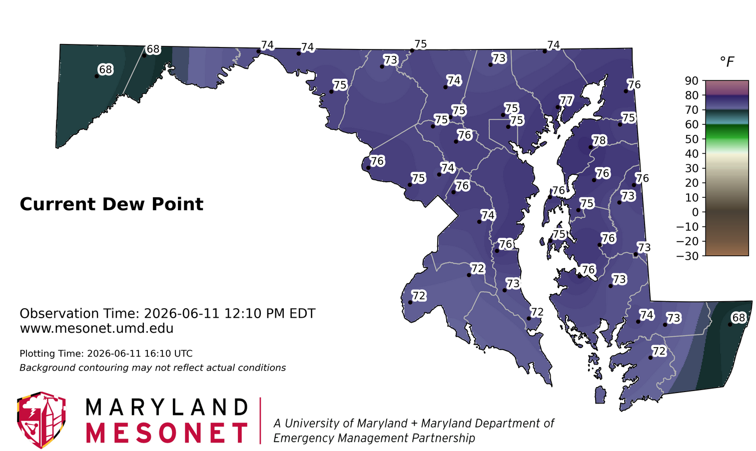
Definitely a plume across Central MD. Though it seems lower dews are just above the surface. The Layhill station recently gusted to 25 mph which coincided with a dew point drop to 63. Back up to 67 now.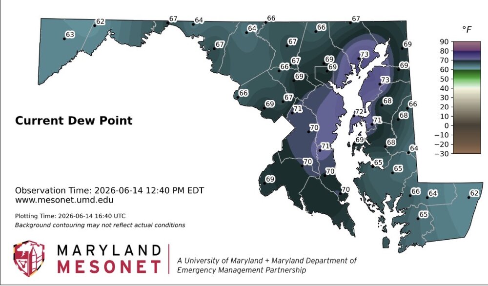
- 892 replies
-
- 2
-
-
- severe
- thunderstorms
- (and 7 more)
-
2026 Mid-Atlantic Severe Storm General Discussion
wxmeddler replied to Kmlwx's topic in Mid Atlantic
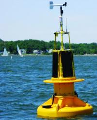
This is an issue with MADIS. The 83 mph gust is from a sonic anemometer on top of the Bay Bridge. That is the first report. The second 83 mph report in Parole is false, it’s due to a bug that duplicates the Bay Bridge sensor at SHA headquarters in Parole. The lay/lon is wrong in MADIS. The 75 mph gust is from a buoy at the mouth of the Severn.- 892 replies
-
- 3
-
-
- severe
- thunderstorms
- (and 7 more)
-
2026 Mid-Atlantic Severe Storm General Discussion
wxmeddler replied to Kmlwx's topic in Mid Atlantic
T-Storm Warning for NoVA -
2026 Mid-Atlantic Severe Storm General Discussion
wxmeddler replied to Kmlwx's topic in Mid Atlantic
Some thoughts on yesterday, then today... Yesterday: Anytime you get a "swashed spider" hodograph, the storms are going to be weaker and messier than just looking at the thermodynamics would expect you to believe. Venting, inflow, water loading, updraft velocity are all going to be negatively impacted. That said, yesterday there was a decent shortwave and enough low level instability that allowed a few storms to develop over/west of the mountains and get the cold pool party started. Once the cold pool production began, the ambient DCAPE and torrid conditions was enough to sustain weak pulse like thunderstorms to the ocean. Limbs start to fail around these parts at around 30 mph, and you start seeing downed trees around 45-50 mph. That is just the nature of the flora in our region, they don't get hit often and so even weak storms do damage. Today: Another weak wave as part of the packet that spawned the tornado outbreak in IL/IN yesterday will move into the western region this afternoon. Theta-E values in excess of 350K with minimal MLCIN should be enough to spark off scattered showers. While overall wind speeds in the lower troposphere are higher today, shear magnitudes remain weak, especially above 3km. Cold Pool propagation and aggregation of these showers should spawn further flank development of showers and thunderstorms. Due to the higher windspeeds aloft today compared to yesterday, storm and cold pool motions will likely be 10kts faster than yesterday. Therefore ground relative windspeeds should be slightly higher today. The question will be storm coverage, which we really won't know for sure until things fire after 3PM. CAM's are hinting that areas south of US50 are more likely than up near the M/D line.- 892 replies
-
- 10
-

-
-
- severe
- thunderstorms
- (and 7 more)
-
2026 Mid-Atlantic Severe Storm General Discussion
wxmeddler replied to Kmlwx's topic in Mid Atlantic
It's always been an issue, but it seems when models get upgraded to more vertical levels it's more of an issue.- 892 replies
-
- 1
-
-
- severe
- thunderstorms
- (and 7 more)
-
2026 Mid-Atlantic Severe Storm General Discussion
wxmeddler replied to Kmlwx's topic in Mid Atlantic
The whales mouth was very good. Very high LCL's though. Would estimate 35-40 mph which lines up with most of the non-sonic wind reports. -
2026 Mid-Atlantic Severe Storm General Discussion
wxmeddler replied to Kmlwx's topic in Mid Atlantic
Depth of the cold pool and surface inversions after the radiation flip over. I think the model cold pools are too shallow and/or the surface inversions are too deep.- 892 replies
-
- 4
-
-
-
- severe
- thunderstorms
- (and 7 more)
-
2026 Mid-Atlantic Severe Storm General Discussion
wxmeddler replied to Kmlwx's topic in Mid Atlantic
Little bit of an enhanced wind from the Middleburg / IAD/ Herndon area. -
2026 Mid-Atlantic Severe Storm General Discussion
wxmeddler replied to Kmlwx's topic in Mid Atlantic
The mega warning has struck the area...- 892 replies
-
- 6
-

-
-
- severe
- thunderstorms
- (and 7 more)
-
Who turned out the lights?
-
2026 Mid-Atlantic Severe Storm General Discussion
wxmeddler replied to Kmlwx's topic in Mid Atlantic
3/4" of Rain in 15 Minutes at the Thurmont MD Mesonet site.- 892 replies
-
- 2
-
-
- severe
- thunderstorms
- (and 7 more)
-
2026 Mid-Atlantic Severe Storm General Discussion
wxmeddler replied to Kmlwx's topic in Mid Atlantic
Am more worried about heavy rain / flash flooding the next few days. Storms will be moving but PWAT's near 2" will dump no matter what. One of our stations (Hancock) got 1/2" in 10 minutes at 4AM this morning in a relatively benign shower.- 892 replies
-
- 3
-
-
- severe
- thunderstorms
- (and 7 more)
-
Hey there! Long time no chat, shame! Although I think my wife and your SO still follow each other on instagram . Congrats on the new-ish position! I've been pulling out my hair for the past 2 years getting this network up and running, although I think @Eskimo Joe beats me in sleep lost. We're working on the datafeeds! We're currently in the process of hiring a developer to create / manage some of that stuff. Congrats on the break-up though! I think you all will do well. Happy to work on a piece if Jason is up for it.
-
I found that beneath the grass (which I just mowed), I had mushrooms growing in my lawn.. Mushrooms! What lawn in a "severe drought" has mushrooms....
-
A bit of a "silent cold front" moving through the area now. Mesonet stations are showing 10F dew point drops within 20 minutes. Current going through Washington/Frederick Counties. Will likely see some 40's for lows tonight again.
-
I also spoke to Louis Uccellini recently, and he also said that they are working on it. No ETA. He got really animated about it though, so it should be good!
-
The coordination between the people in Omaha and local monitors is not the best. Good news (at least in MD) but in other places, it is getting better... slowly. It usually takes 2-4 weeks for the drought monitor to "catch up" and even then they are very hesitant to take areas out of drought.
- 259 replies
-
- 1
-
-
- we got burned
- rugpull central
- (and 1 more)
-
I'm debating on mowing today, dealing with the damp grass in the blades, and having it short so the ground can dry out. Or waiting till the weekend so that the grass is dry but is gonna be 4" taller. Decisions.
-
Let the dry out begin...
-
Neeeeed.
-
That was a crazy game. They were out of it so many times. Got saved by the overturned call at home.
-
If I go on a Jebwalk in the summer, I'll make sure to take my machete.
- 259 replies
-
- 1
-
-
- we got burned
- rugpull central
- (and 1 more)