wxmeddler
-
Posts
7,013 -
Joined
-
Last visited
Content Type
Profiles
Blogs
Forums
American Weather
Media Demo
Store
Gallery
Everything posted by wxmeddler
-
I was out on the Allegany / Garrett county border today, the smoke was definitely noticeable between the ridges.
-
We created this animation / video of the heat indices over the heatwave. 380,000 data points in 5 minutes. https://drive.google.com/file/d/1reTXiqRwfQw1g8udC0H29Po6FsajkJVt/view?usp=sharing
-
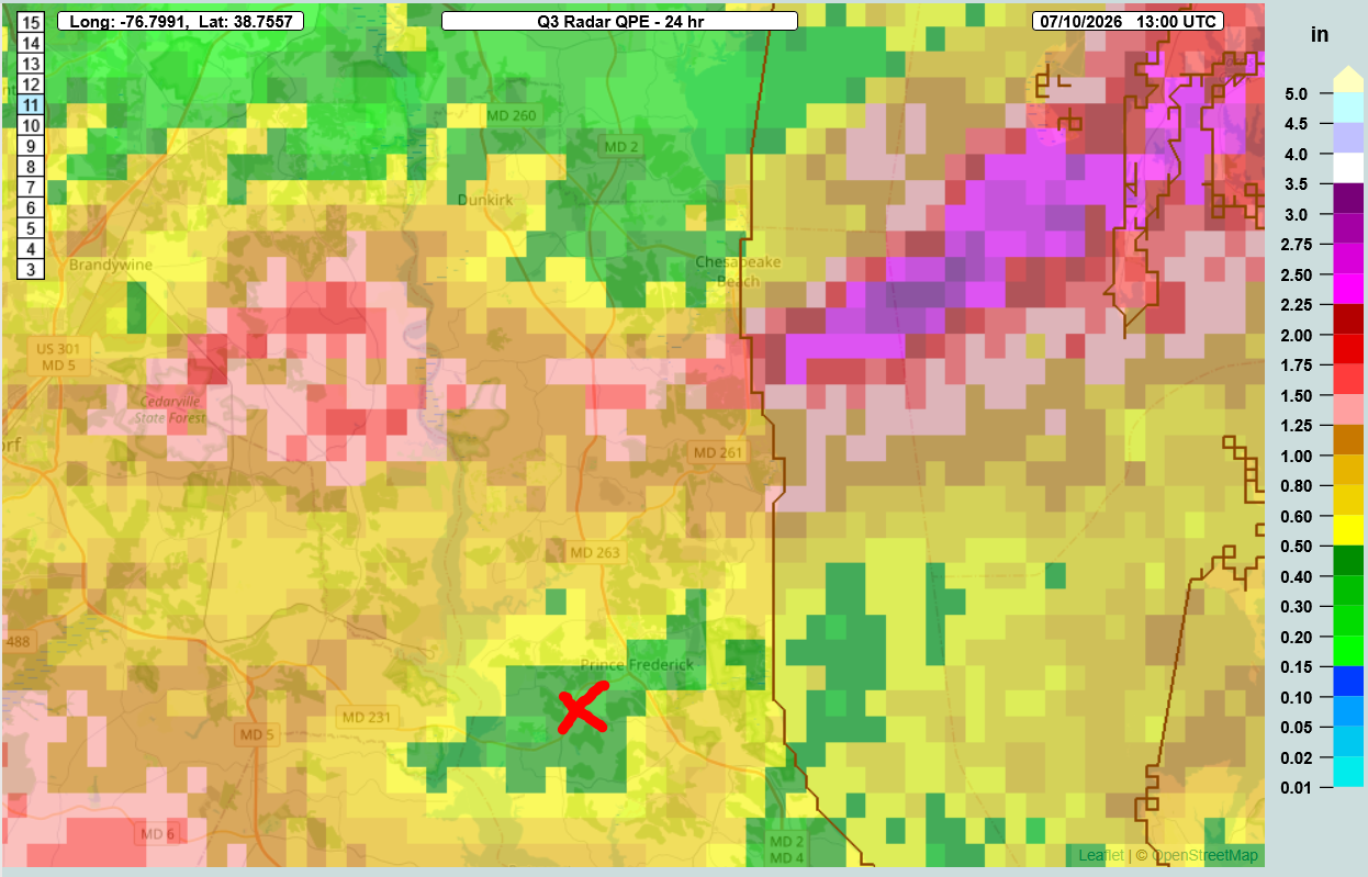
There was a sharp cut-off there. The Red X is where the Prince Frederick mesonet site is. It got the short end of the stick.

-
@Mrs.J Can I send this into the NWS and the county EM?
-
Looks like you're getting your wish.
-
Concerning...Severe potential...Watch likely Valid 091805Z - 092000Z Probability of Watch Issuance...80 percent SUMMARY...Damaging wind gusts are possible as convection continues to intensify and move eastward this afternoon. A watch is likely. DISCUSSION...Convection along a stationary boundary has shown modest intensification over the last hour near the MD/PA border. Additional convection is developing along the Blue Ridge. Sufficiently strong westerly winds across the Ridge will eventually move convection to the east. Furthermore, around 30 kt of effective shear will be present allowing for stronger storm cells and linear structures. Low-level lapse rates will continue to steepen this afternoon, though cloud cover has been greater in the vicinity of the Chesapeake Bay. Given the potential for one or more clusters to evolve this afternoon, a watch is likely to address the threat for damaging wind gusts. ..Wendt/Hart.. 07/09/2026
-
Baseline SVR T-Storm for Northern Loudoun / Southern Frederick Edit: FFW for southern Frederick suburbs now.
-
I think given the heatwave and the 4th holiday weekend is over it's transitioned back to the July Obs thread.
-
Apparently there are water rescue calls starting to appear in Manassas.
-
Luckily that NW HoCo / NE MoCo storm is in a place that isn't very populated. I'm at home in Laurel and I can hear it from here. She's loud.
-
PWAT from the LWX 20z Balloon was 1.89” and these storms aren’t moving anywhere fast.
-
This looks like a smoothing artifact of whatever visualizer they are using.
-
They got Bay Breeze'd and since the Heat Index is more sensitive to Dew Point more than it is temperature, it went crazy.
-
Correct. Apparent Temp is Heat Index and/or Wind Chill. Yes. It's what the NWS systems call it.
-
I had nothing to do with the conceptions of it. I just run it. There was a push by MDEM to have a mesonet system following the success in other states. University of Maryland agreed to partner with the effort and it was just a matter of funding to show up for it. That's a very short narrative for a long process, but that's the gist of it.
-
I can vouch for this as well. Northeastern AA Co especially due to the orientation of the Severn / Magothy Rivers. The same goes for places such as Middle River up to Aberdeen with southerly winds. Edit: It's 87/78/100 at 11pm in College Park with SW winds coming from the DC Heat Island... Blehhhhhhh
-
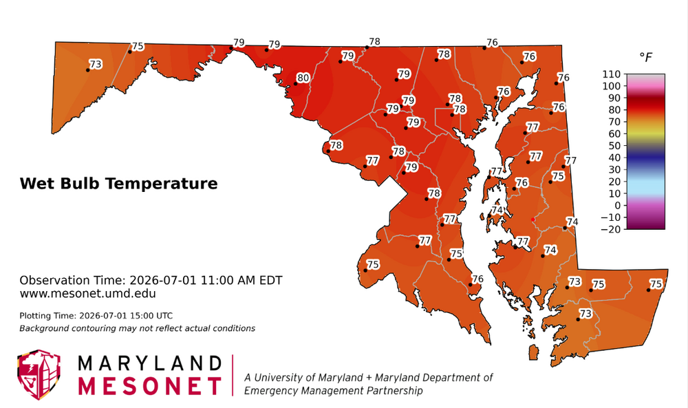
The white line is for Heat Advisory Threshold (100F) and Pink for Extreme Heat Warning threshold (110). That's why the colors.
-
Even if you hop out of the pool, you'll still be 80 deg.
-
In North Dakota we regularly saw -12 to -18F inversions between 0.5 and 9m. Between +2 and +6F during the daytime depending on soil dryness and vegetation. AASC Standard is between 1.5m and 2m. WMO is 2m. I prefer the 1.5m personally, but MD Mesonet follows the 2m.
-
Definitely an odd mesoscale setup with the old modified arctic airmass sitting off the coast and mixing down the drier air on the eastern shore whole the mountains get obscene moisture
-
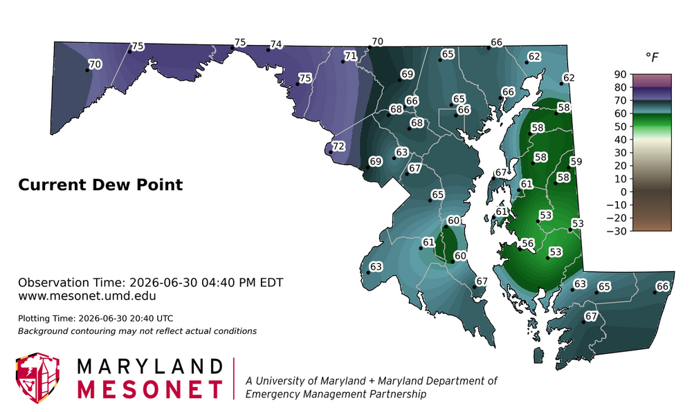
Thew MD Mesonet station in Frostburg is hovering around a dewpoint of 75-76 degrees with a station pressure of 939.8mb. That's 21 g/kg Mixing ratio which is CRAZY.
-
The offense and relief need more work than the defense to be honest. And for the defense, it's the left side infield that's mostly the problem.
-
I was at the O's game last night. Besides the two defensive mistakes by the infield (only one of which was an error). The O's did not do terrible. The score did not reflect how close it was IMHO.
-
It usually is not. I'm trying to change that here at UMD. I consider myself somewhat of a Meteorologist Metrologist myself. Though I'm always humbled by those NIST people.
-
Having lived in North Dakota for a decade, this is spot on. With heat, once you're naked or have loose all white clothing on, there's nothing else you can do. With cold, just put on more layers. I will take -10 / -10 vs. 100/75 any day. Can you believe I have to work with this guy?