wxmeddler
-
Posts
7,013 -
Joined
-
Last visited
Content Type
Profiles
Blogs
Forums
American Weather
Media Demo
Store
Gallery
Everything posted by wxmeddler
-
I got woken up by the sound of heavy rain. I went to go see and just after I opened the door I saw a flash of light. I thought to myself “no, can’t be” then boom. Yep! What a surprise that is!
-

Feb 22nd/23rd "There's no way..." Storm Thread
wxmeddler replied to Maestrobjwa's topic in Mid Atlantic
Cut-Off's (especially decaying ones) suck to forecast man... -
Feb 22nd/23rd "There's no way..." Storm Thread
wxmeddler replied to Maestrobjwa's topic in Mid Atlantic
Need the Alberta s/w to either show up in the OHV 12 hrs earlier or just not show up at all. Euro has the messiest of both. -
Feb 22nd/23rd "There's no way..." Storm Thread
wxmeddler replied to Maestrobjwa's topic in Mid Atlantic
I'm at H42, southern stream s/w looks slightly deeper and a tad west. The alberta s/w is very strung out over the dakotas. The "middle stream" s/w is getting ahead of the southern s/w. Looks messy. -
Feb 22nd/23rd "There's no way..." Storm Thread
wxmeddler replied to Maestrobjwa's topic in Mid Atlantic
AIFS brings in the Alberta s/w faster and thus is later with the phase. It takes longer / further east to go negative tilt. Ironically, the opposite of the direction of the trends with the GFS/NAM with the alberta s/w lagging behind and not interacting with the southern stream, and acting as more like a kicker. -
Feb 22nd/23rd "There's no way..." Storm Thread
wxmeddler replied to Maestrobjwa's topic in Mid Atlantic
Oh man, that's pretty.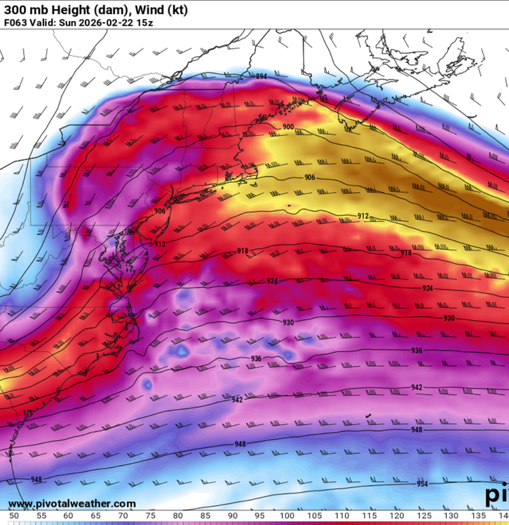
-
Feb 22nd/23rd "There's no way..." Storm Thread
wxmeddler replied to Maestrobjwa's topic in Mid Atlantic
Looks like the NAM more than anything else, the Alberta s/w is hanging back. -
Feb 22nd/23rd "There's no way..." Storm Thread
wxmeddler replied to Maestrobjwa's topic in Mid Atlantic
I'm not a fan of the FV3 core at sub-10km-ish scales. Glad the plan is to drop it in favor of MPAS. However, we're gonna loose the NAM and have the RRFS FV3 only for a year or two before the switch to MPAS apparently. -
Feb 22nd/23rd "There's no way..." Storm Thread
wxmeddler replied to Maestrobjwa's topic in Mid Atlantic
It's good. The lagging s/w coming out of Alberta is interesting, but good trends for the coastal. -
Feb 22nd/23rd "There's no way..." Storm Thread
wxmeddler replied to Maestrobjwa's topic in Mid Atlantic
Much more negatively tilted on the 18z EPS / AIEPS. Still goes to our east / too late to curl into the coast, but a concession. -
Feb 22nd/23rd "There's no way..." Storm Thread
wxmeddler replied to Maestrobjwa's topic in Mid Atlantic
Holy Shift -
Feb 22nd/23rd "There's no way..." Storm Thread
wxmeddler replied to Maestrobjwa's topic in Mid Atlantic
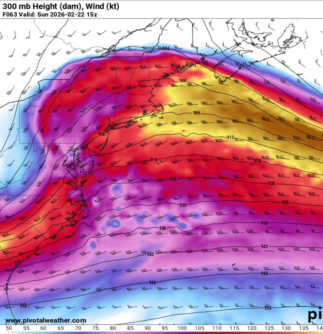
For the Euro watchers, I will say that the 12z Op is now definitely an outlier in the cohesiveness and timing of the s/w rounding the OHV. The foreign global and AI are much more set on a more westward solution. To the extent of the 18z GFS? lol no, but I'd say at this point we have something decent to work with here for measurable snow at least for eastern portions of the board. -
We are giving it credit because it shows the most snow. I think if you polled the mets and serious forecasters here they would say that it's likely not correct but it is "interesting". Next step for the snow lovers is to see if other guidance starts to bend towards the westerly solution.
-
Feb 22nd/23rd "There's no way..." Storm Thread
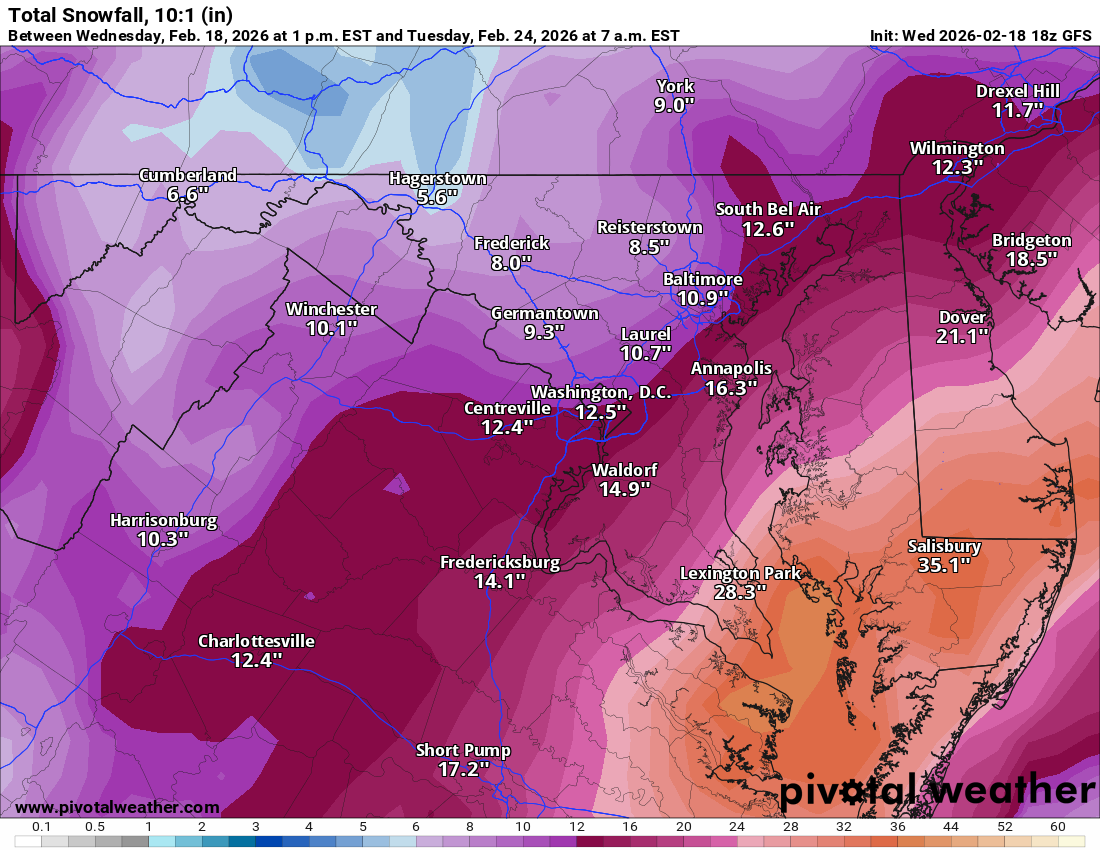
wxmeddler replied to Maestrobjwa's topic in Mid Atlantic
Here is the 10:1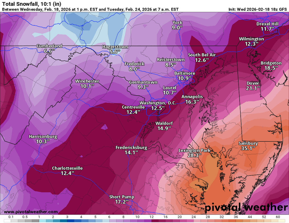
-
Feb 22nd/23rd "There's no way..." Storm Thread
wxmeddler replied to Maestrobjwa's topic in Mid Atlantic
That verbatim (which I don't believe for a second) would be an all-time eastern shore crippler. -
Feb 22nd/23rd "There's no way..." Storm Thread
wxmeddler replied to Maestrobjwa's topic in Mid Atlantic
Brought it 100 miles west. -
Feb 22nd/23rd "There's no way..." Storm Thread
wxmeddler replied to Maestrobjwa's topic in Mid Atlantic
Holy ---- the GFS. What the ---- -
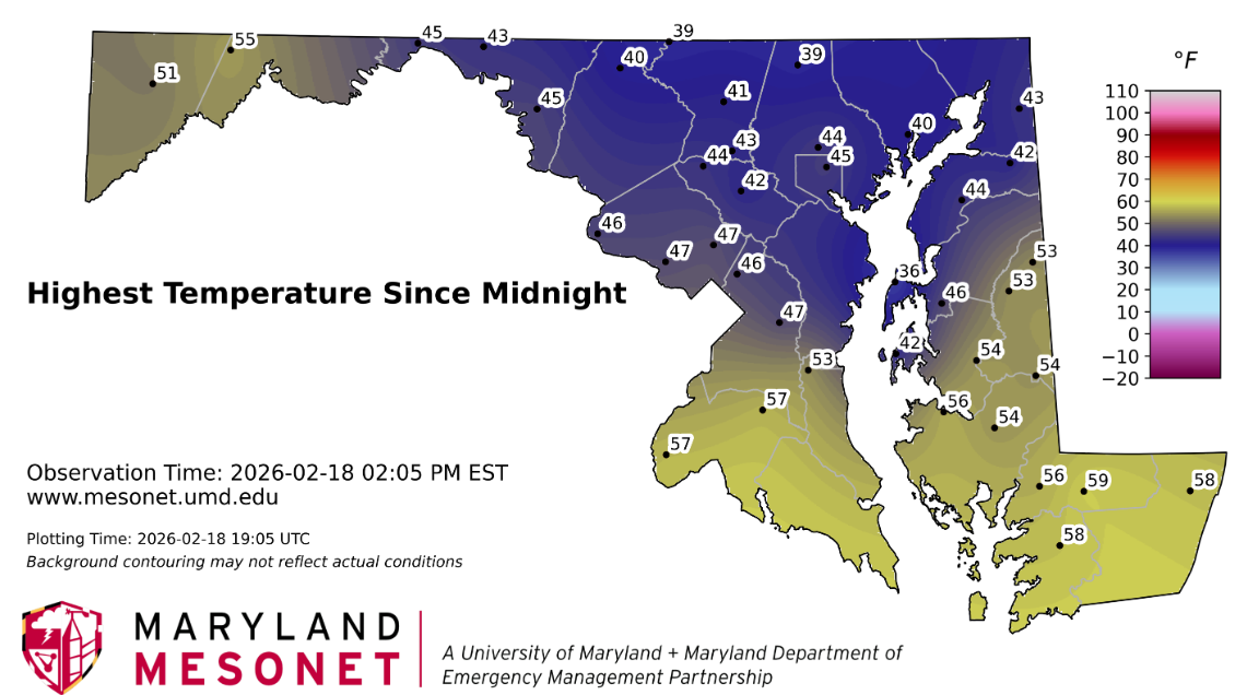
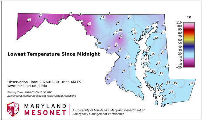
The coldest spot in the mesonet today is the Kent Island station with a NE sea-breeze.

-
Yeah, it's a good hit. The H5 really digs. Need another scoot 150 mi west, that's asking for a lot though. (It will be 300mi east next run)
-
Horrible run to run consistency with the GFS so far. But this run looks good at h96 thus far.
-
I'm a simple man, I see a thread pinned for an event within 5 days, I click. Let's start this slop-clock!
-
I have seen 7 Snowflakes today. Not quite to my personal 10 flakes to a trace threshold.
-
It's in a mini-cold sink. Cannan of the Maryland Piedmont
-
Impressive
-
I didn’t think 60 was ever really in the cards for this event. The boundary layer really only has ~45 kts. I want to see 60kts in order to get 60mph.