wxmeddler
-
Posts
7,044 -
Joined
-
Last visited
Content Type
Profiles
Blogs
Forums
American Weather
Media Demo
Store
Gallery
Everything posted by wxmeddler
-
Getting a little worried about the Sunday / Monday rain event... the setup seems fairly primed to produce flooding somewhere in the ridge/valley and piedmont region.
-
Yes. Next question... It honestly has to do with the experience of the person in the hot seat. The operators down in Oklahoma / Texas / Kansas etc. are good because they've had the reps. As you move east there is a tendency over warn just because of the lack of events to get practice on what does and does not produce. The training is helpful but provides 50 cases at most. You really need hundreds / thousands to get good.
-

2026 Mid-Atlantic Severe Storm General Discussion
wxmeddler replied to Kmlwx's topic in Mid Atlantic
Trees are the real killer to reliability. A major issue is that we're getting to the point in some of the older suburbs / planned communities that the trees planted at the time of housing construction are reaching the post-maturity age. They are going to fail/fall, and unless the landowner / HOA / town / county is on top of it (they are not), then you're gonna get outages with 30 mph gusts.- 1,688 replies
-
- 2
-

-
- severe
- thunderstorms
- (and 7 more)
-
2026 Mid-Atlantic Severe Storm General Discussion
wxmeddler replied to Kmlwx's topic in Mid Atlantic
- 1,688 replies
-
- 2
-
-
- severe
- thunderstorms
- (and 7 more)
-
Hi, Yes. We're in active discussions about multiple sites in the county(ies). Hopefully something soon.
-
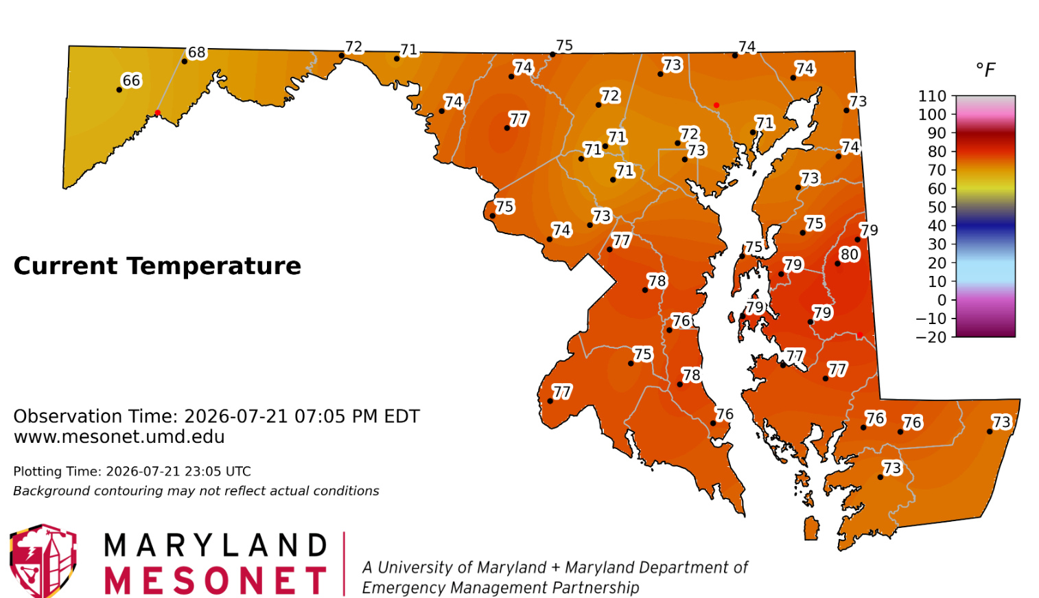
Quite impressive that most areas didn't get above 80. The high clouds staved it off.
-
Today was a great day to work outside. Still a touch warm for my liking on where I was on the eastern shore. Prefer 72 over 82 with full sunshine this time of year but I'll take what I can get with these dew points today.
-
2026 Mid-Atlantic Severe Storm General Discussion
wxmeddler replied to Kmlwx's topic in Mid Atlantic
Just rain and wind from here on out mostly. And most of the wind threat will likely be US50 and south. -
2026 Mid-Atlantic Severe Storm General Discussion
wxmeddler replied to Kmlwx's topic in Mid Atlantic
The atmosphere is pretty well turned over at this point. Not sure we're going to get much more in the way of tornadoes unless it's some QLCS / bookend thing.
-
2026 Mid-Atlantic Severe Storm General Discussion
wxmeddler replied to Kmlwx's topic in Mid Atlantic
Very obvious TDS west of Winchester. LWX has gone radar confirmed.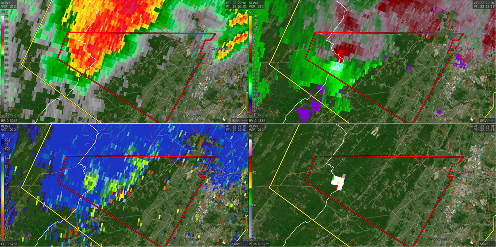
-
2026 Mid-Atlantic Severe Storm General Discussion
wxmeddler replied to Kmlwx's topic in Mid Atlantic
The best looking hodographs come in around 20z and last through about 3z. Eastern shore looks thermodynamically best right now given the satellite but the are better hodographs west. Convective temperatures are around 95F -ish, and we're not gonna get there in N/W of I-95 with the clouds. This is all for semi-isolated supercell stuff... if you just want a thunderstorm, you'll get a good chance of that everywhere later.- 1,688 replies
-
- 1
-
-
- severe
- thunderstorms
- (and 7 more)
-
2026 Mid-Atlantic Severe Storm General Discussion
wxmeddler replied to Kmlwx's topic in Mid Atlantic
That looks like 65 mph damage, there were pockets of 80 in there from TDWR. Locally more damaging than the '12 derecho. I think the derecho only had 50-65 in the Pasadena / Rivera Beach area. -
There was quite blue skies this morning, but it's gotten progressively worse as the day goes on. Smoke and haze.
-
2026 Mid-Atlantic Severe Storm General Discussion
wxmeddler replied to Kmlwx's topic in Mid Atlantic
More bulk shear and more low level curvature. 10-15 kt southeaserlies at the surface with 20 kt southerlies at 850 would have done the trick for tornadoes. Mid-Level dry air pocket for more widespread winds.- 1,688 replies
-
- 1
-

-
- severe
- thunderstorms
- (and 7 more)
-
That's over where my parents live... my mom said the traffic light was out at Lake Waterford Park. Yeah, most of the damage was north / east of MD100 / MD10.
-
There was a fairly widespread area of 60mph+ returns on BWI TDWR from about MD10 eastward. A few pockets of 80. Not surprising.
-
2026 Mid-Atlantic Severe Storm General Discussion
wxmeddler replied to Kmlwx's topic in Mid Atlantic
Too much moisture in the mixed phase regions for large hail production, the Wet Bulb 0C is up at 4km. Though both Frederick area and BWI impressively reported small hail despite that. The thermodynamics more represents a deep tropical look than anything else. Explains the prolific lightning production. The bulk shear above 30 kts meant we had supercells right at the start, like near Frederick. Once the wet downbursts started though, the lack of low level shear and curvature meant that any low level mesocyclone was squashed out early. To your point; The lack of any EML or capping also meant that those boundaries went and upscaled, “polluting” the environment.- 1,688 replies
-
- 1
-
-
- severe
- thunderstorms
- (and 7 more)
-
2026 Mid-Atlantic Severe Storm General Discussion
wxmeddler replied to Kmlwx's topic in Mid Atlantic
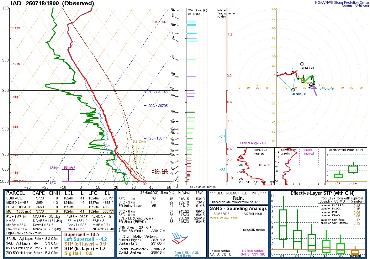
For the record here is the 18z LWX Balloon. Really impressive thermodynamically. Not so impressive kinematically. Shear is lackluster for anything organized.
- 1,688 replies
-
- 3
-
-
- severe
- thunderstorms
- (and 7 more)
-
2026 Mid-Atlantic Severe Storm General Discussion
wxmeddler replied to Kmlwx's topic in Mid Atlantic
I haven't seen any reports of non-tree based damage. Most stuff I've seen has been tree damage that seems 60 mph or less. -
2026 Mid-Atlantic Severe Storm General Discussion
wxmeddler replied to Kmlwx's topic in Mid Atlantic
METAR KBWI 182005Z 33021G53KT 3/4SM R15R/1000V5000FT +TSRAGR BR SCT013 BKN044CB OVC100 23/22 A2986 RMK AO2 PK WND 30053/2002 WSHFT 1951 GRB05 PRESRR CONS LTGICCCCG ALQDS TS ALQDS MOV E GR 1/2 P0014 T02330222 $ 53 KTS and 1/2" Hail to boot!- 1,688 replies
-
- 2
-
-
- severe
- thunderstorms
- (and 7 more)
-
2026 Mid-Atlantic Severe Storm General Discussion
wxmeddler replied to Kmlwx's topic in Mid Atlantic
The most impressive wind signature of the day so far is right over BWI... will be interesting to see what they report. TDWR says 55-60 mph. -
I mentioned in the severe thread, but the lightning today region wide in these storms will be no joke. A combination of lots of water and lots of lift in the phase transition layer is going to equal a lot of lightning.
-
2026 Mid-Atlantic Severe Storm General Discussion
wxmeddler replied to Kmlwx's topic in Mid Atlantic
The lightning today is no joke with all the water and MLCAPE in the phase transition layer.- 1,688 replies
-
- 6
-
-
- severe
- thunderstorms
- (and 7 more)
-
2026 Mid-Atlantic Severe Storm General Discussion
wxmeddler replied to Kmlwx's topic in Mid Atlantic
There is a decent meso aloft, but there's nothing about today or the storm itself that would suggest that we could see anything truly tornadic today. Too wet, and not enough SRH / Bulk Shear. If anyone does see something it will be akin to scud sucking on a the edge of an outflow boundary.- 1,688 replies
-
- 1
-

-
- severe
- thunderstorms
- (and 7 more)
-
The smoke today smells worse than usual. The smoke I remember out west was a straight campfire smell. This smells like campfire mixed with New Jersey (a mix of burning rubber and bad BO).