hawkeye_wx
-
Posts
6,618 -
Joined
-
Last visited
Content Type
Profiles
Blogs
Forums
American Weather
Media Demo
Store
Gallery
Everything posted by hawkeye_wx
-

Major Hurricane Melissa - 892mb - 185mph Jamaica landfall
hawkeye_wx replied to GaWx's topic in Tropical Headquarters
Latest dropsonde says 913 mb. Max nw side FL wind is 158 kts. -
Major Hurricane Melissa - 892mb - 185mph Jamaica landfall
hawkeye_wx replied to GaWx's topic in Tropical Headquarters
This afternoon is when models have it taking a fairly sharp right turn. -
Major Hurricane Melissa - 892mb - 185mph Jamaica landfall
hawkeye_wx replied to GaWx's topic in Tropical Headquarters
Dropsonde says 924 mb -
Major Hurricane Melissa - 892mb - 185mph Jamaica landfall
hawkeye_wx replied to GaWx's topic in Tropical Headquarters
The next recon plane just took off from Curacao and will be in the eye in a couple hours. -
Major Hurricane Melissa - 892mb - 185mph Jamaica landfall
hawkeye_wx replied to GaWx's topic in Tropical Headquarters
Latest recon pass found 128 kts flight level in the right quad, so that has been pretty steady. -
Major Hurricane Melissa - 892mb - 185mph Jamaica landfall
hawkeye_wx replied to GaWx's topic in Tropical Headquarters
933 mb from the dropsonde -
Major Hurricane Melissa - 892mb - 185mph Jamaica landfall
hawkeye_wx replied to GaWx's topic in Tropical Headquarters
extrap 932 mb -
Major Hurricane Melissa - 892mb - 185mph Jamaica landfall
hawkeye_wx replied to GaWx's topic in Tropical Headquarters
It appears the Google DeepMind model will be one of the winners again. Several other models kept wanting to bring Melissa farther north, in between Haiti and Jamaica or into eastern Jamaica from the east/southeast. The Google ensembles never budged from the wsw/west track to the south of Jamaica. -
Major Hurricane Melissa - 892mb - 185mph Jamaica landfall
hawkeye_wx replied to GaWx's topic in Tropical Headquarters
Next recon is scheduled to be in there around 2330z. Every 6 hours there will be a new recon plane. -
Major Hurricane Melissa - 892mb - 185mph Jamaica landfall
hawkeye_wx replied to GaWx's topic in Tropical Headquarters
So what about the previous 10 recon passes today that did not confirm the NHC intensity? Did those not count? The NHC even said in their discussion their estimate might be generous. It's no big deal. It was likely going to strengthen more at some point today/tonight. Melissa absolutely looks better now than it did this morning. Much sharper edges of the eye and CDO. -
Major Hurricane Melissa - 892mb - 185mph Jamaica landfall
hawkeye_wx replied to GaWx's topic in Tropical Headquarters
Dropsonde says ~944 mb. -
Major Hurricane Melissa - 892mb - 185mph Jamaica landfall
hawkeye_wx replied to GaWx's topic in Tropical Headquarters
The wind still hasn't risen at all today. Satellite looks like cat 4, but recon hasn't found any cat 4 FL wind. -
Major Hurricane Melissa - 892mb - 185mph Jamaica landfall
hawkeye_wx replied to GaWx's topic in Tropical Headquarters
Pressure has dropped to 947 mb, so intensification has resumed. -
Major Hurricane Melissa - 892mb - 185mph Jamaica landfall
hawkeye_wx replied to GaWx's topic in Tropical Headquarters
3rd recon pass this morning continues to find a steady-state storm. The pressure is 953 mb, actually up a hair, and 120 kts flight level in the right (strongest) quad, which equates to 125 mph at the surface using the NHC's 0.9 method. -
Major Hurricane Melissa - 892mb - 185mph Jamaica landfall
hawkeye_wx replied to GaWx's topic in Tropical Headquarters
The new recon plane suggests this is actually not a cat 4. The latest NHC estimate is too low by 8 mb. The pressure has only dropped from 959 to 952 over the last several hours. Also, the new plane did not find any increase in wind on its first pass, whereas the NHC increased the wind by 20 mph. -
Major Hurricane Melissa - 892mb - 185mph Jamaica landfall
hawkeye_wx replied to GaWx's topic in Tropical Headquarters
Officially 959 mb from the dropsonde. -
Major Hurricane Melissa - 892mb - 185mph Jamaica landfall
hawkeye_wx replied to GaWx's topic in Tropical Headquarters
Final recon pass until morning found 114 kts flight level and 959 mb extrap. This thing is barely moving. -
Major Hurricane Melissa - 892mb - 185mph Jamaica landfall
hawkeye_wx replied to GaWx's topic in Tropical Headquarters
967 mb, 115 kts flight level on the last pass. The eye has been tracking south of west this evening. -
Major Hurricane Melissa - 892mb - 185mph Jamaica landfall
hawkeye_wx replied to GaWx's topic in Tropical Headquarters
969 mb, 111 kts flight level wind It is nearing cat 3. -
Major Hurricane Melissa - 892mb - 185mph Jamaica landfall
hawkeye_wx replied to GaWx's topic in Tropical Headquarters
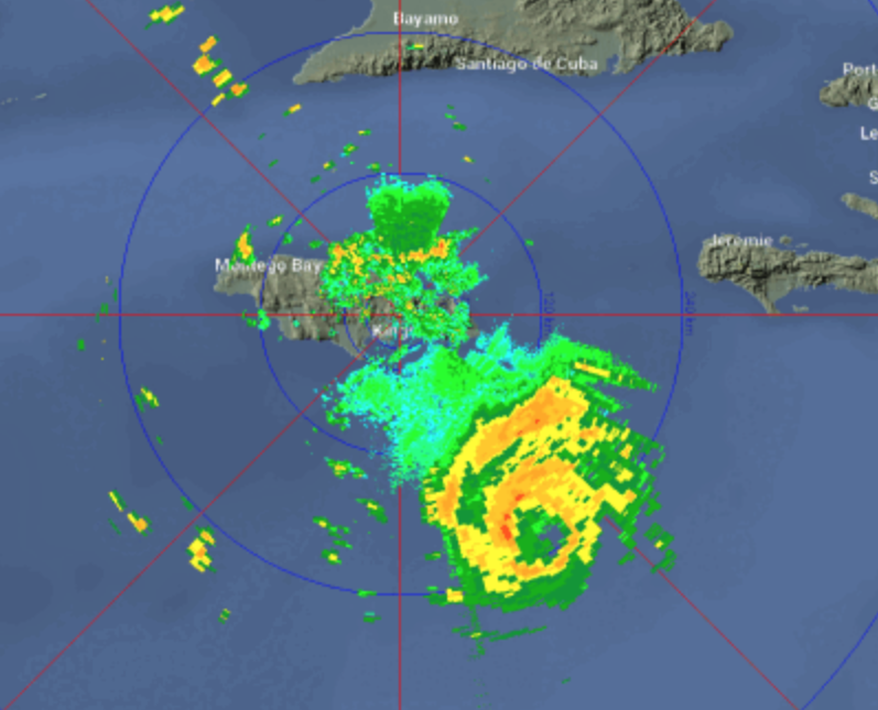
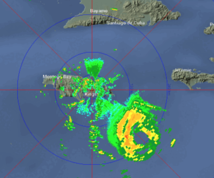
-
Major Hurricane Melissa - 892mb - 185mph Jamaica landfall
hawkeye_wx replied to GaWx's topic in Tropical Headquarters
Still 971 mb... no drop over the last 90 minutes. -
Major Hurricane Melissa - 892mb - 185mph Jamaica landfall
hawkeye_wx replied to GaWx's topic in Tropical Headquarters
97 kts flight level, 970 mb extrap -
Major Hurricane Melissa - 892mb - 185mph Jamaica landfall
hawkeye_wx replied to GaWx's topic in Tropical Headquarters
The Google model continues to not budge. Many of its tracks are south of west for the next couple days.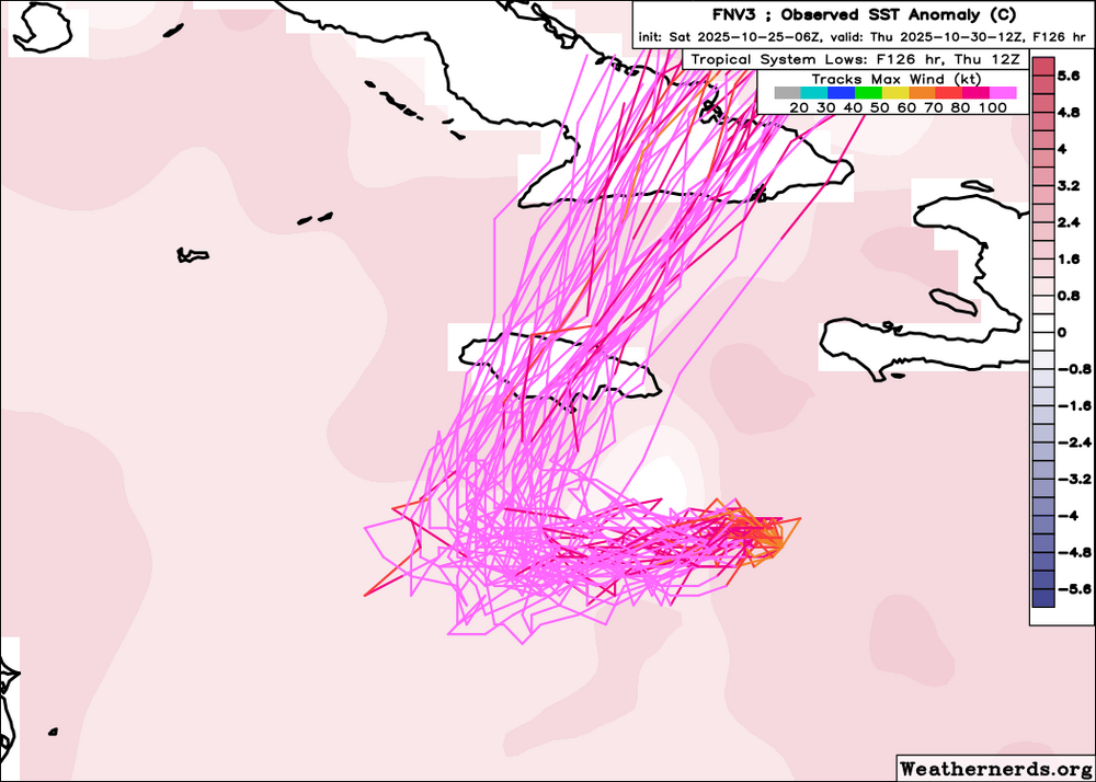
-
Major Hurricane Melissa - 892mb - 185mph Jamaica landfall
hawkeye_wx replied to GaWx's topic in Tropical Headquarters
The favorable conditions really collapse on tonight's Euro once Melissa gets to Jamaica.