Met1985
-
Posts
16,911 -
Joined
-
Last visited
Content Type
Profiles
Blogs
Forums
American Weather
Media Demo
Store
Gallery
Everything posted by Met1985
-

2022-2023 Fall/Winter Mountains Thread
Met1985 replied to BlueRidgeFolklore's topic in Southeastern States
Not sure how this will translate but it may ley the ull strengthen more our way. -
2022-2023 Fall/Winter Mountains Thread
Met1985 replied to BlueRidgeFolklore's topic in Southeastern States
The 18z gfs is much different than last runs. It's closes the ull off much much quicker. -
The “is it ever going to snow again” discussion.
Met1985 replied to psuhoffman's topic in Mid Atlantic
Good luck to the Mid Atlantic crew. May yall see some snow soon. -
Deepends on the strength of the ULL. Also in WNC we have something called elevation that helps tremendously. And I don't mean a measly 1000' but 3500' plus which helps us out a lot.
-
2022-2023 Fall/Winter Mountains Thread
Met1985 replied to BlueRidgeFolklore's topic in Southeastern States
The moisture isn't there on the euro like on the gfs but it's in the right direction in my opinion. -
2022-2023 Fall/Winter Mountains Thread
Met1985 replied to BlueRidgeFolklore's topic in Southeastern States
Euro just caved to the gfs with the bowling ball ull. I can't believe I actually said that this season. -
We are hoping. It's crazy some of our sites down here have had more snow than some of the places up here even though we are still well below average in snowfall.
-
2022-2023 Fall/Winter Mountains Thread
Met1985 replied to BlueRidgeFolklore's topic in Southeastern States
The gfs continues with the same general look. At this point it's the idea but the euro ain't buying it. The euro slashed snowfall overnight and that's concerning. -
2022-2023 Fall/Winter Mountains Thread
Met1985 replied to BlueRidgeFolklore's topic in Southeastern States
Yeah that may be a possibility. I just used the 10:1 usually because it's a standard ratio it seems. -
2022-2023 Fall/Winter Mountains Thread
Met1985 replied to BlueRidgeFolklore's topic in Southeastern States
Gfs is trending very interesting to say the least Sent from my SM-G998U using Tapatalk
-
2022-2023 Fall/Winter Mountains Thread
Met1985 replied to BlueRidgeFolklore's topic in Southeastern States
Went up on the parkway this weekend near black Balsam. Sent from my SM-G998U using Tapatalk -
Yeah this would fit in nicely for the mjo and the SSW coming in the next week. It probably will be right because we are supposed to be headed into warm months. Just go ahead and mess up spring as well lol.
-
2022-2023 Fall/Winter Mountains Thread
Met1985 replied to BlueRidgeFolklore's topic in Southeastern States
Yeah all the models have been showing persistence with this front swinging through and showing some upslope snow for most of the border counties. It'll be a shock after such a nice week. -
Yeah @GaWx has had a lot of great information on this recently. You should check it out in the SE forum.
-
2022-2023 Fall/Winter Mountains Thread
Met1985 replied to BlueRidgeFolklore's topic in Southeastern States
Not bad once the wind died down. Ended up hitting 12 this morning. -
2022-2023 Fall/Winter Mountains Thread
Met1985 replied to BlueRidgeFolklore's topic in Southeastern States
Dang that is crazy. -
2022-2023 Fall/Winter Mountains Thread
Met1985 replied to BlueRidgeFolklore's topic in Southeastern States
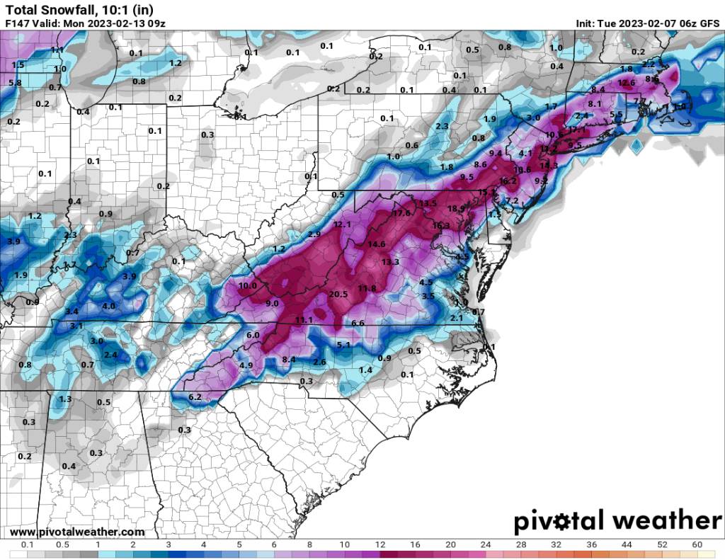
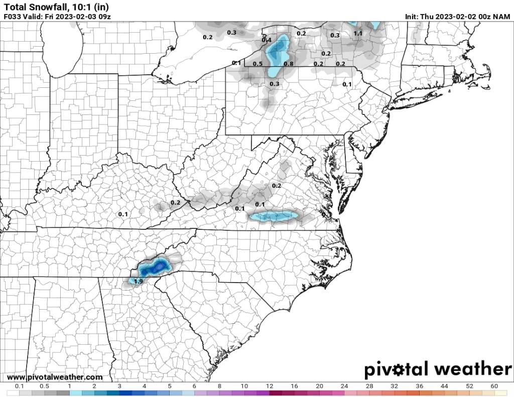
This mornings NAM loses all the snowfall. -
2022-2023 Fall/Winter Mountains Thread
Met1985 replied to BlueRidgeFolklore's topic in Southeastern States
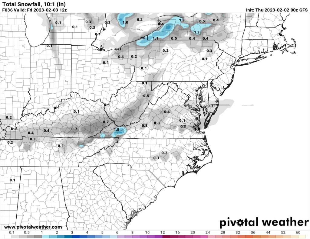
00z gfs continues to say what snow. Sent from my SM-G998U using Tapatalk
-
2022-2023 Fall/Winter Mountains Thread
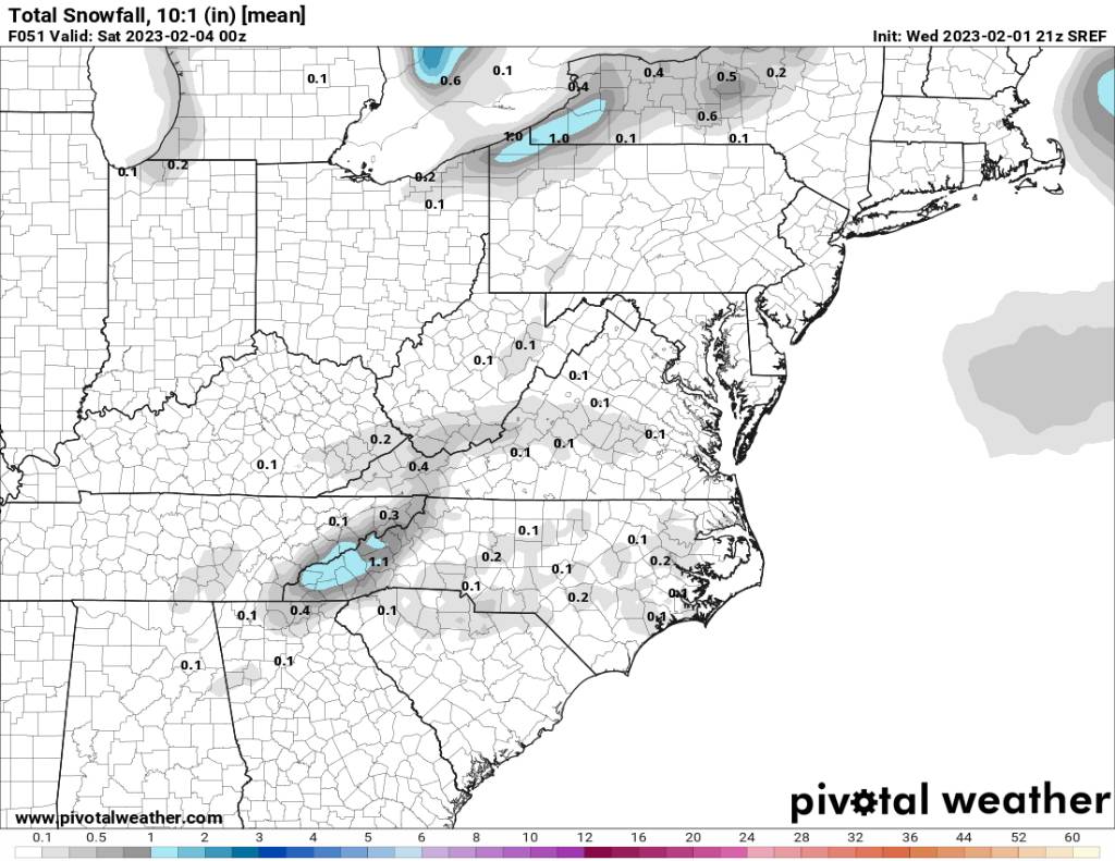
Met1985 replied to BlueRidgeFolklore's topic in Southeastern States
21z SREF plums Sent from my SM-G998U using Tapatalk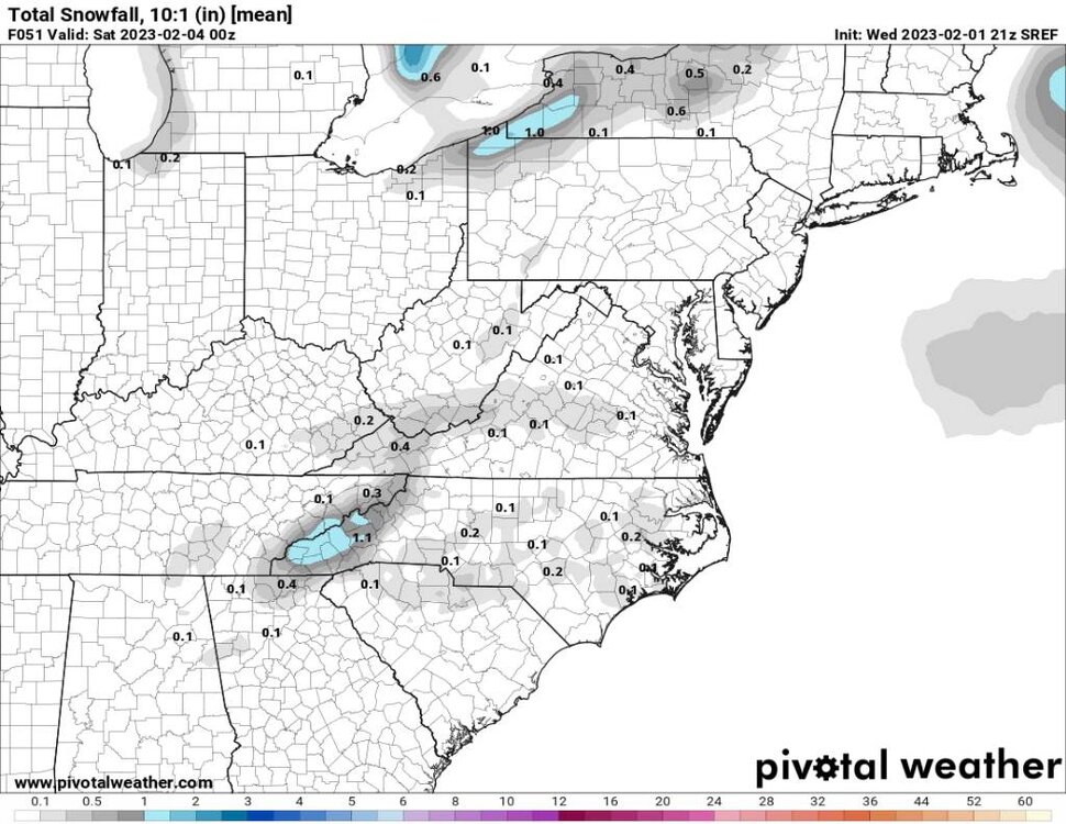
-
2022-2023 Fall/Winter Mountains Thread
Met1985 replied to BlueRidgeFolklore's topic in Southeastern States
00z nam. Definitely looking like a southern mountains hit according to the nam. Sent from my SM-G998U using Tapatalk
-
2022-2023 Fall/Winter Mountains Thread
Met1985 replied to BlueRidgeFolklore's topic in Southeastern States
18z NAM 3k just for posterity Sent from my SM-G998U using Tapatalk.thumb.jpg.dba8d2443496b4a6eb8d69b849d719c4.jpg)
-
2022-2023 Fall/Winter Mountains Thread
Met1985 replied to BlueRidgeFolklore's topic in Southeastern States
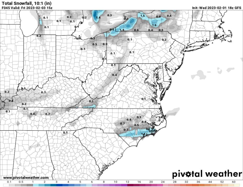
18z gfs says no snow. Sent from my SM-G998U using Tapatalk
-
2022-2023 Fall/Winter Mountains Thread
Met1985 replied to BlueRidgeFolklore's topic in Southeastern States
I know! I really hope the NAM can actually catch this one and hold onto it. -
2022-2023 Fall/Winter Mountains Thread
Met1985 replied to BlueRidgeFolklore's topic in Southeastern States
18z NAM. Back on that good stuff. Sent from my SM-G998U using Tapatalk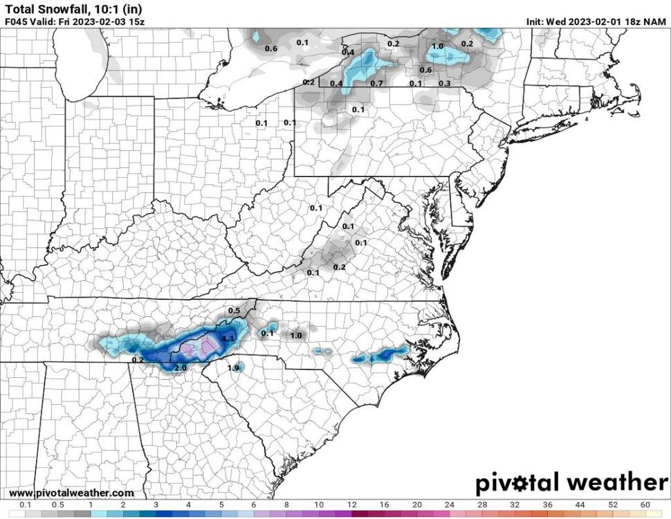


.jpg.52b4df036ba783812140f4fdec119fcb.jpg)