Met1985
-
Posts
16,924 -
Joined
-
Last visited
Content Type
Profiles
Blogs
Forums
American Weather
Media Demo
Store
Gallery
Everything posted by Met1985
-

2022-2023 Fall/Winter Mountains Thread
Met1985 replied to BlueRidgeFolklore's topic in Southeastern States
It is a crying shame that in the extended range in January we get a low that tracks south of us and we still cannot pull a snowstorm out of that scenario. I don't care what you say. That is a sign of a crap pattern if there ever was one. -
2022-2023 Fall/Winter Mountains Thread
Met1985 replied to BlueRidgeFolklore's topic in Southeastern States
Again on the 12z gfs suite the se ridge is getting besten back by the tpv which could allow for a sneaky system late in the game. My target date of 01-30 has been cooling down since yesterday on the operationals and the ensembles. -
2022-2023 Fall/Winter Mountains Thread
Met1985 replied to BlueRidgeFolklore's topic in Southeastern States
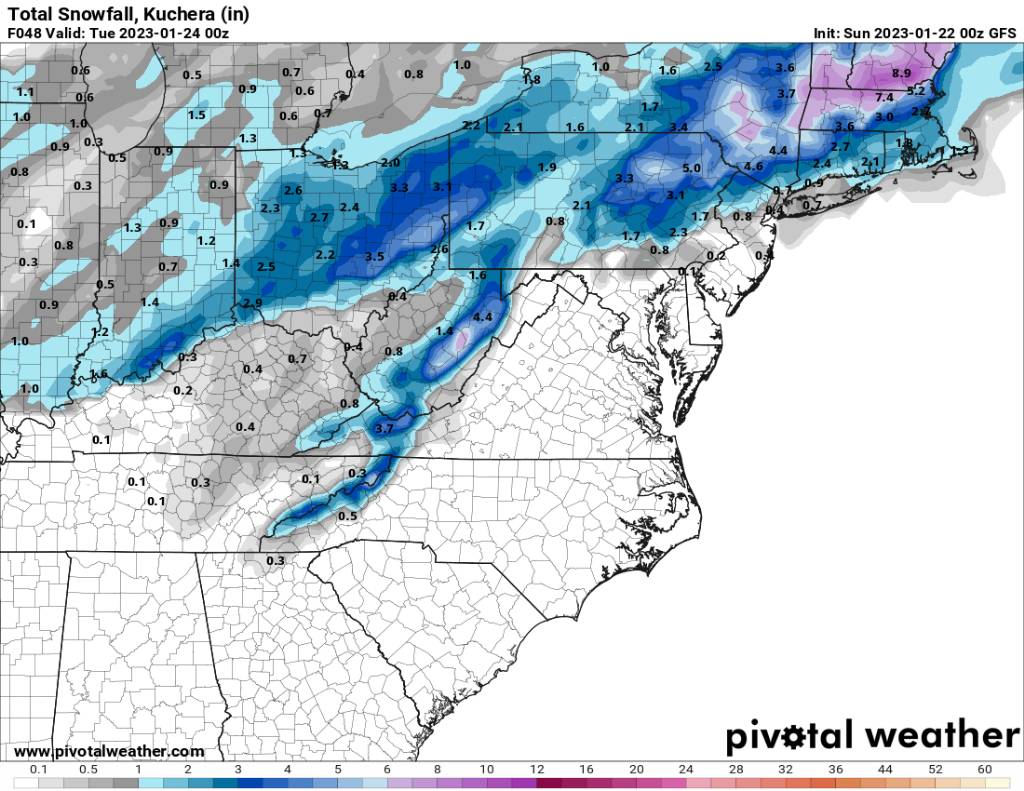
On the 12z gfs the clipper coming in looks best for the northern mountains. It looks pathetic really. Seems like it's going the way of the euro. Sent from my SM-G998U using Tapatalk
-
2022-2023 Fall/Winter Mountains Thread
Met1985 replied to BlueRidgeFolklore's topic in Southeastern States
12z gfs goes with more of a uniform look across the mountains Sent from my SM-G998U using Tapatalk
-
2022-2023 Fall/Winter Mountains Thread
Met1985 replied to BlueRidgeFolklore's topic in Southeastern States
12z NAM going with the north mountains currently. Sent from my SM-G998U using Tapatalk.thumb.jpg.d399cf1dfd3366782bc92d1a2961dd42.jpg)
-
2022-2023 Fall/Winter Mountains Thread
Met1985 replied to BlueRidgeFolklore's topic in Southeastern States
I've noticed that the ensembles have backed off the se ridge today even the eps but the eps is the warmer Ensemble out of all of them which is concerning. -
2022-2023 Fall/Winter Mountains Thread
Met1985 replied to BlueRidgeFolklore's topic in Southeastern States
Temp just backed down to 31 with some snow mixing in now. Back to bed for me. -
2022-2023 Fall/Winter Mountains Thread
Met1985 replied to BlueRidgeFolklore's topic in Southeastern States
Good morning everyone. Surprisingly we are sitting right at 32 degrees getting a mixture of rain and sleet this morning. -
2022-2023 Fall/Winter Mountains Thread
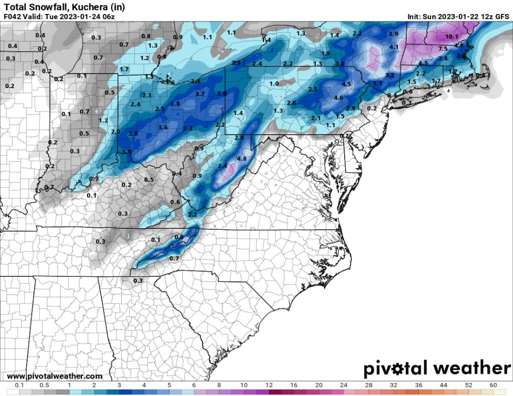
Met1985 replied to BlueRidgeFolklore's topic in Southeastern States
The 00z gfs for tomorrow night into Monday Sent from my SM-G998U using Tapatalk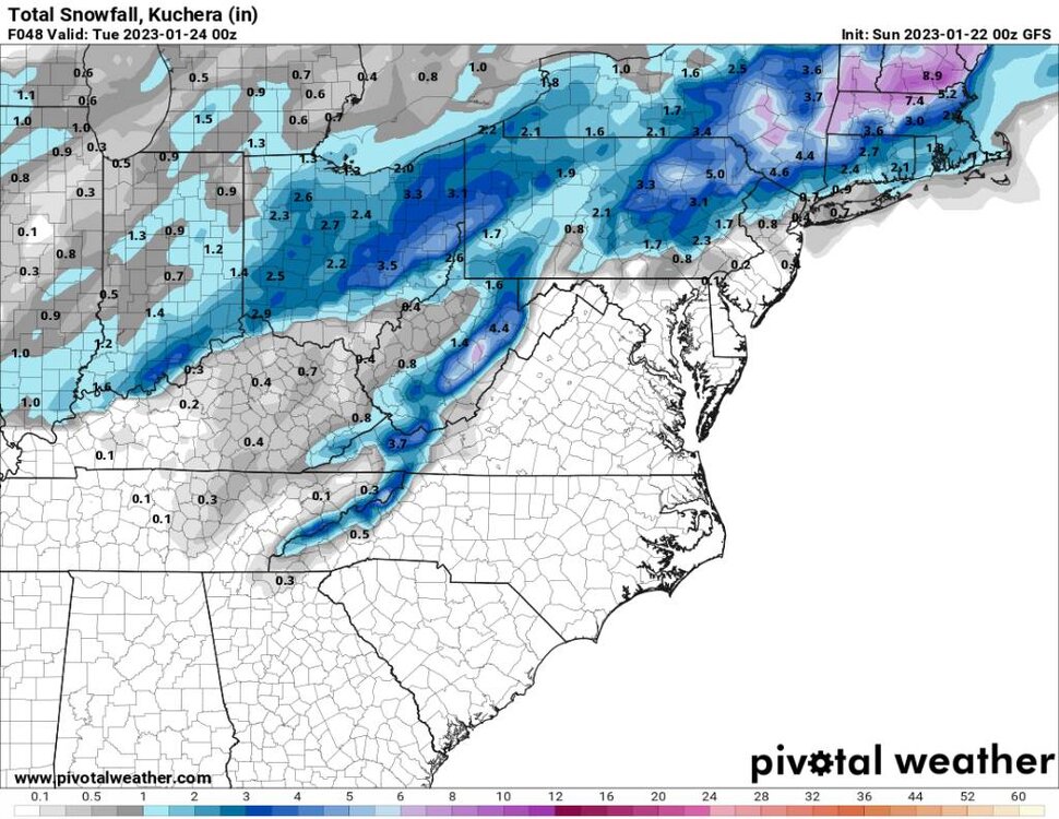
-
2022-2023 Fall/Winter Mountains Thread
Met1985 replied to BlueRidgeFolklore's topic in Southeastern States
Im not trying to be a downer but this is concerning to me. The second image was from the eps 12z suite for 01-30, the first image is from today's eps 12z suite for the same time frame. You go from a decent look to the SE RIDGE flexing. Sent from my SM-G998U using Tapatalk -
2022-2023 Fall/Winter Mountains Thread
Met1985 replied to BlueRidgeFolklore's topic in Southeastern States
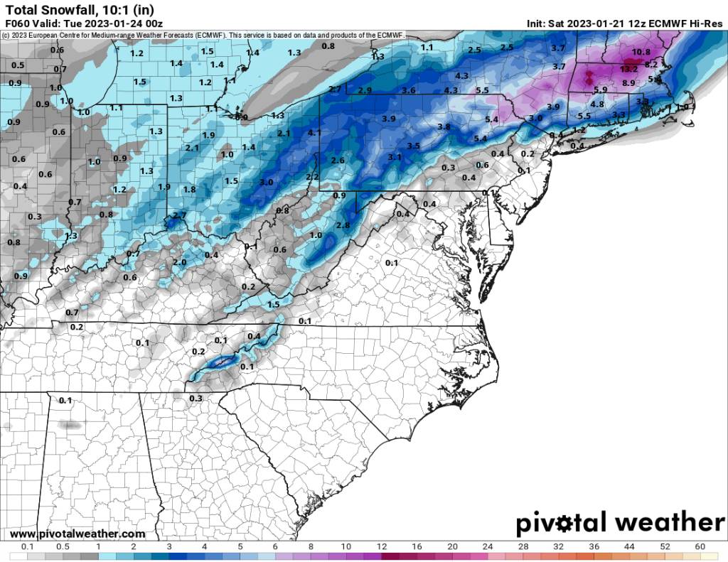
The is the 12z euro at hour 60. Sent from my SM-G998U using Tapatalk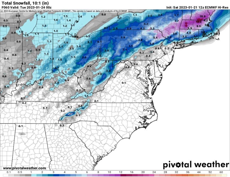
-
2022-2023 Fall/Winter Mountains Thread
Met1985 replied to BlueRidgeFolklore's topic in Southeastern States
00z NAM is a nice hit for the mountains. Sent from my SM-G998U using Tapatalk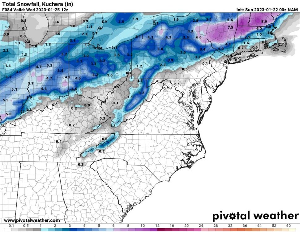
-
2022-2023 Fall/Winter Mountains Thread
Met1985 replied to BlueRidgeFolklore's topic in Southeastern States
The SE ridge is relentless on todays maps. That and diving systems down to the four corners doesn't do us any good. -
Yeah we've seen this song and dance a lot.
-
January 2023 Medium/Long Range Pattern Discussion Thread
Met1985 replied to Carvers Gap's topic in Tennessee Valley
Yeah this run is much better than the overnight runs in my opinion.- 923 replies
-
- 2
-

-
- warm start
- cold
- (and 4 more)
-
2022-2023 Fall/Winter Mountains Thread
Met1985 replied to BlueRidgeFolklore's topic in Southeastern States
The gfs is the only model this morning that looks decent for upslope snow. The euro is paltry and the NAM has back off it's totals. Also once we get this cold front around the 27th the whole country goes zonal and we end up warming right back up. -
2022-2023 Fall/Winter Mountains Thread
Met1985 replied to BlueRidgeFolklore's topic in Southeastern States
Ashe-Alleghany NC-Watauga-Tazewell-Smyth-Bland-Giles-Wythe- Pulaski-Montgomery-Grayson-Carroll-Floyd-Craig-Alleghany VA-Bath- Roanoke-Botetourt-Rockbridge-Patrick-Franklin-Bedford-Amherst- Mercer-Summers-Monroe-Eastern Greenbrier-Western Greenbrier- Including the cities of West Jefferson, Sparta, Boone, Tazewell, Marion, Bland, Pearisburg, Wytheville, Radford, Pulaski, Blacksburg, Independence, Whitetop, Troutdale, Volney, Galax, Floyd, New Castle, Clifton Forge, Covington, Hot Springs, Roanoke, Salem, Fincastle, Lexington, Buena Vista, Stuart, Rocky Mount, Bedford, Amherst, Bluefield, Hinton, Hix, Union, Lewisburg, White Sulphur Springs, Quinwood, Duo, and Rainelle 405 AM EST Sat Jan 21 2023 ...WINTER WEATHER ADVISORY IN EFFECT FROM 4 AM TO 4 PM EST SUNDAY... * WHAT...Areas of sleet and freezing rain expected. Total sleet accumulations of up to a half inch and ice accumulations of up to a tenth of an inch. * WHERE...Portions of northwest North Carolina, southwest and west central Virginia and southeast West Virginia. * WHEN...From 4 AM to 4 PM EST Sunday. -
2022-2023 Fall/Winter Mountains Thread
Met1985 replied to BlueRidgeFolklore's topic in Southeastern States
Looks like it some ice tomorrow for the favored CAD regions. Buncombe- Including the cities of Asheville, Black Mountain, and Candler 421 AM EST Sat Jan 21 2023 ...WINTER WEATHER ADVISORY IN EFFECT FROM MIDNIGHT TONIGHT TO NOON EST SUNDAY... * WHAT...Freezing rain expected. Total ice accumulations of less than a tenth of an inch. * WHERE...High elevations of Buncombe County around the Black Mountains. * WHEN...From midnight tonight to noon EST Sunday. -
2022-2023 Fall/Winter Mountains Thread
Met1985 replied to BlueRidgeFolklore's topic in Southeastern States
Yeah when a track like this upcoming weekend brings rain to all of us you know it's a crap pattern. Yep. -
January 2023 Medium/Long Range Pattern Discussion Thread
Met1985 replied to Carvers Gap's topic in Tennessee Valley
Yeah the pattern change I just don't see at this point. My opinion is we don't see a true pattern change until March then that will screw up Spring. This is just a repeating pattern from September in my opinion. Not bad but not great. -
2022-2023 Fall/Winter Mountains Thread
Met1985 replied to BlueRidgeFolklore's topic in Southeastern States
Yeah the so called pattern change is not going to come to fruition until probably March.... There has been a recurring theme that has repeated since September. And that is exactly what we are looking at. At this point the only way we get a synoptic storm is threading the needle on a storm because we are getting plenty of moisture in here. -
2022-2023 Fall/Winter Mountains Thread
Met1985 replied to BlueRidgeFolklore's topic in Southeastern States
Truthfully im not impressed with the upcoming pattern. Everything cuts then get have a cold front then back to warmth because majority of the cold air is in the Rockies. Im just about done with January at this point. Things have not trended well. -
That will not affect our weather until February. Primarily mid to Late February and there is no guarantee that it affects us in the positive.
-
2022-2023 Fall/Winter Mountains Thread
Met1985 replied to BlueRidgeFolklore's topic in Southeastern States
Another really good run by the EPS. Cold is near by with a damn active storm track. That's about all you can ask for at this juncture. -
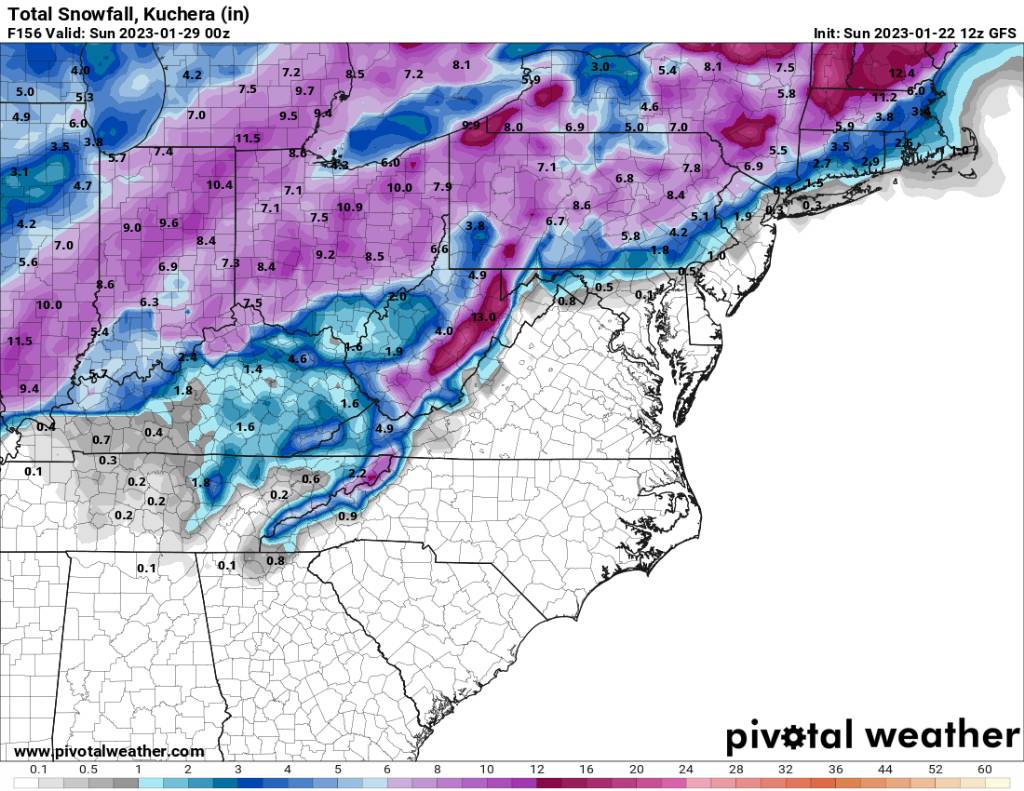
2022-2023 Fall/Winter Mountains Thread
Met1985 replied to BlueRidgeFolklore's topic in Southeastern States
The 12z gfs has a ton of potential and still showing some mighty cold air coming in.
.jpg.75cc81ff0cc34ba444c8674c6875044d.jpg)