Met1985
-
Posts
16,911 -
Joined
-
Last visited
Content Type
Profiles
Blogs
Forums
American Weather
Media Demo
Store
Gallery
Everything posted by Met1985
-

2022-2023 Fall/Winter Mountains Thread
Met1985 replied to BlueRidgeFolklore's topic in Southeastern States
06z gfs snowfall total. This run just crushes the mountains. Some insane totals in this run. Sent from my SM-G998U using Tapatalk.thumb.jpg.4c672a7cd1379c7316f46d4e5c50f1b0.jpg)
-
2022-2023 Fall/Winter Mountains Thread
Met1985 replied to BlueRidgeFolklore's topic in Southeastern States
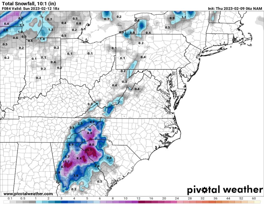
The 06z NAM snowfall total through 84 hours but it was still snowing hard at the last frame. Another solution though. Sent from my SM-G998U using Tapatalk
-
2022-2023 Fall/Winter Mountains Thread
Met1985 replied to BlueRidgeFolklore's topic in Southeastern States
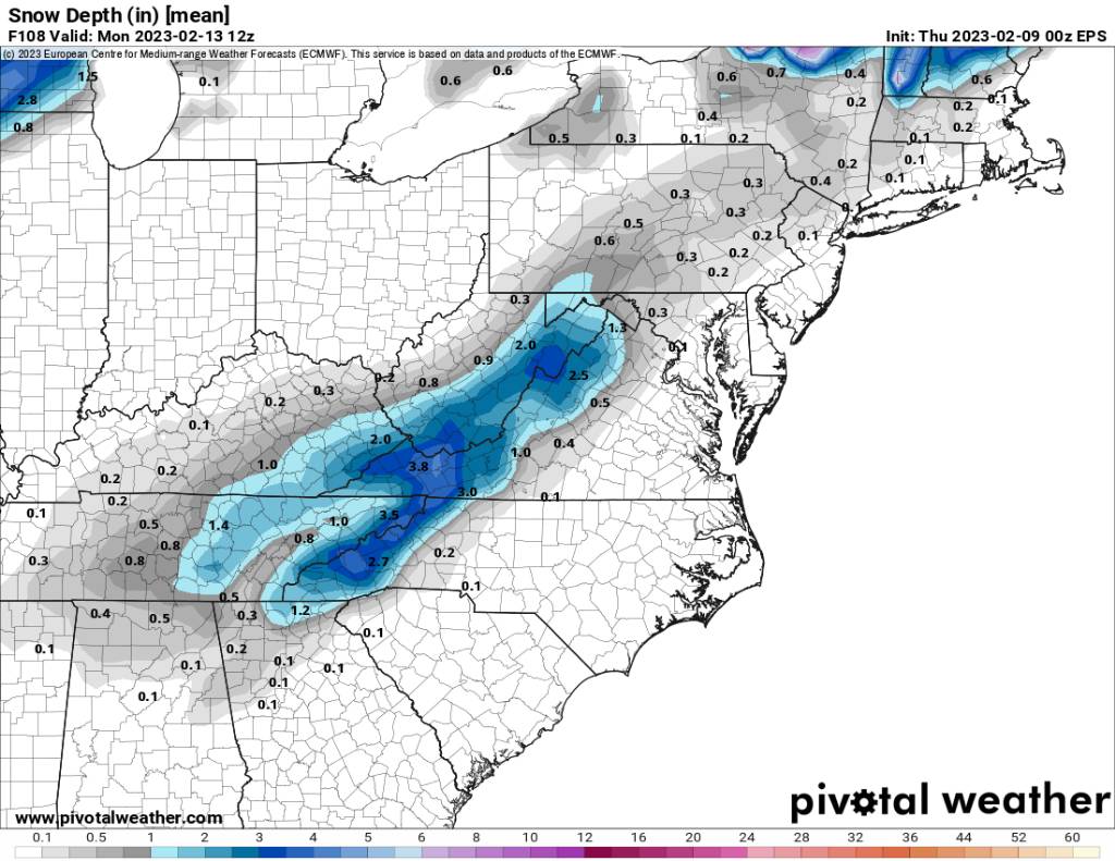
This is the snowfall depth mean on the eps. That's all I could pull from pivitol. Again the mountains are the most favorable. Sent from my SM-G998U using Tapatalk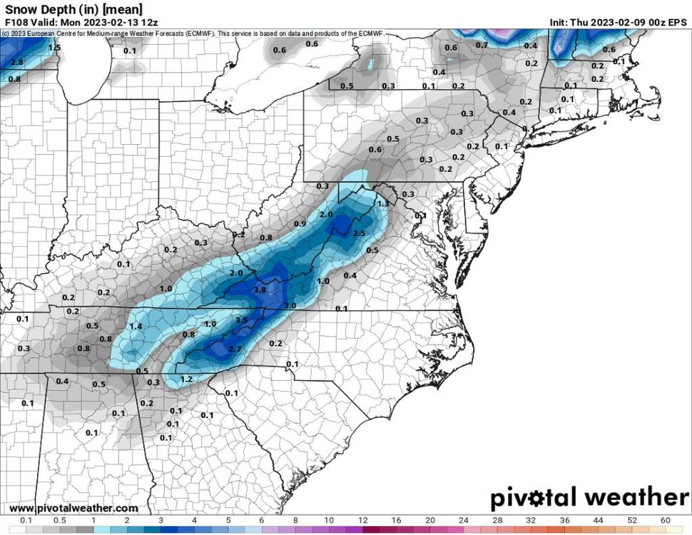
-
2022-2023 Fall/Winter Mountains Thread
Met1985 replied to BlueRidgeFolklore's topic in Southeastern States
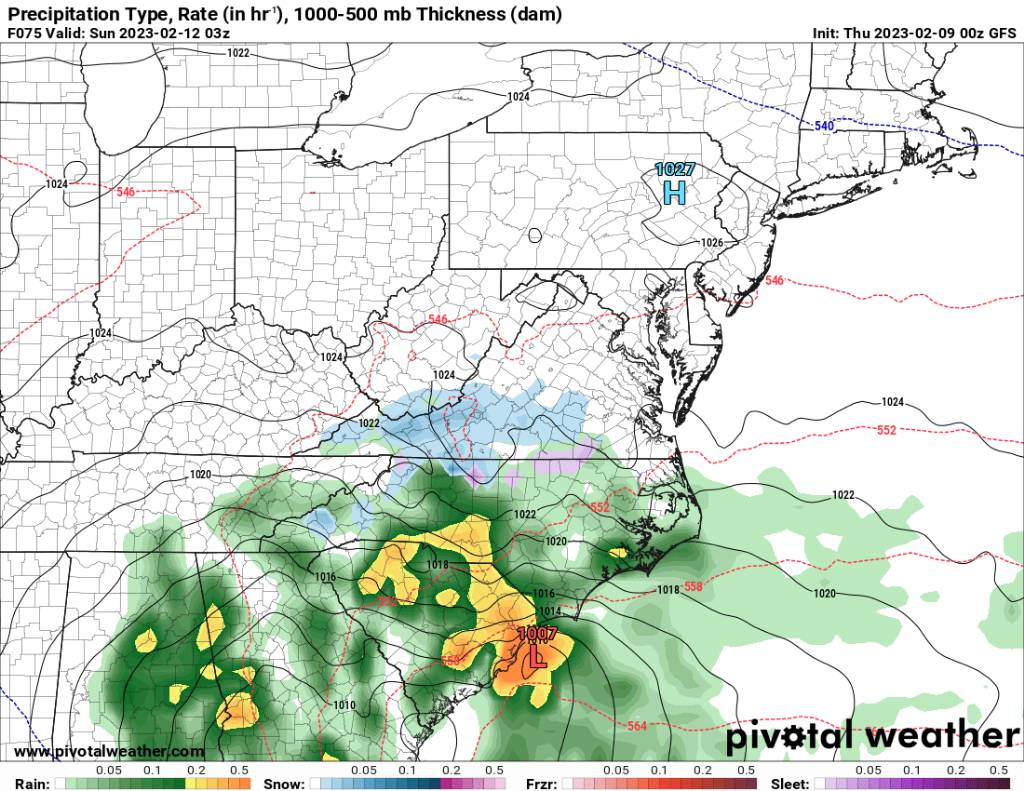
Not real concerned with the movement of the precipitation field currently. This is far from being hammered out. We may have to wait until Friday to get a great read on the exact track because that will determine who are the winners and losers in this storm. -
2022-2023 Fall/Winter Mountains Thread
Met1985 replied to BlueRidgeFolklore's topic in Southeastern States
00z euro. Middle Tennessee is the winner this time. Sent from my SM-G998U using Tapatalk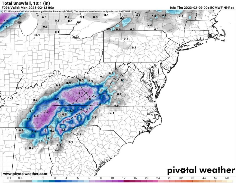
-
2022-2023 Fall/Winter Mountains Thread
Met1985 replied to BlueRidgeFolklore's topic in Southeastern States
This looks like a mess on the euro. For some reason the ull is stronger but lacking moisture. -
2022-2023 Fall/Winter Mountains Thread
Met1985 replied to BlueRidgeFolklore's topic in Southeastern States
The ull cuts much further West than the gfs does. -
2022-2023 Fall/Winter Mountains Thread
Met1985 replied to BlueRidgeFolklore's topic in Southeastern States
This is a stronger storm on the Euro than the gfs. -
2022-2023 Fall/Winter Mountains Thread
Met1985 replied to BlueRidgeFolklore's topic in Southeastern States
GEFS snowfall mean. A great signal for the mountains. Sent from my SM-G998U using Tapatalk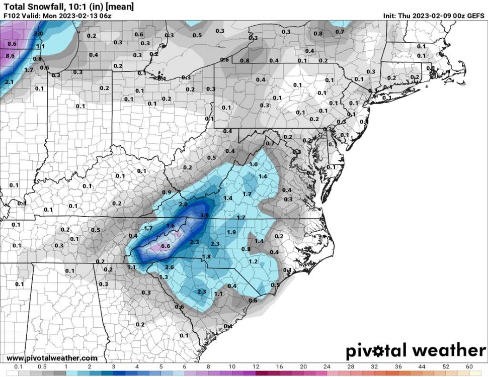
-
2022-2023 Fall/Winter Mountains Thread
Met1985 replied to BlueRidgeFolklore's topic in Southeastern States
Im afraid that this storm is going to be very elevation dependent. -
2022-2023 Fall/Winter Mountains Thread
Met1985 replied to BlueRidgeFolklore's topic in Southeastern States
Posting snowfall map for new page. Sent from my SM-G998U using Tapatalk.thumb.jpg.603447d734f9bf15abc9e080e15ba654.jpg)
-
2022-2023 Fall/Winter Mountains Thread
Met1985 replied to BlueRidgeFolklore's topic in Southeastern States
That is one hell of a snowstorm for us in the mountains. Moderate to heavy snowfall for the majority of the storm. -
2022-2023 Fall/Winter Mountains Thread
Met1985 replied to BlueRidgeFolklore's topic in Southeastern States
00z gfs snowfall map. Sent from my SM-G998U using Tapatalk.thumb.jpg.fc3521965208e93db26b8b1dd3719c5d.jpg)
-
2022-2023 Fall/Winter Mountains Thread
Met1985 replied to BlueRidgeFolklore's topic in Southeastern States
Hour 93 on the gfs. The piedmont getting into some snow action. Sent from my SM-G998U using Tapatalk.thumb.jpg.2d6e3bf961d75da22b2d9b0020e206e5.jpg)
-
2022-2023 Fall/Winter Mountains Thread
Met1985 replied to BlueRidgeFolklore's topic in Southeastern States
This actually might be one hell of a run for us. -
2022-2023 Fall/Winter Mountains Thread
Met1985 replied to BlueRidgeFolklore's topic in Southeastern States
Hour 87.... Sent from my SM-G998U using Tapatalk.thumb.jpg.66eea4c46ac4290a7611c8c71fd2c4b6.jpg)
-
2022-2023 Fall/Winter Mountains Thread
Met1985 replied to BlueRidgeFolklore's topic in Southeastern States
Hour 84 on gfs. Sent from my SM-G998U using Tapatalk.thumb.jpg.35f2b850501251acd1410c1c34b3d513.jpg)
-
2022-2023 Fall/Winter Mountains Thread
Met1985 replied to BlueRidgeFolklore's topic in Southeastern States
Hour 81 on 00z gfs. Sent from my SM-G998U using Tapatalk.thumb.jpg.a7589bde99227b608c831df0a745ac45.jpg)
-
2022-2023 Fall/Winter Mountains Thread
Met1985 replied to BlueRidgeFolklore's topic in Southeastern States
Looks like it's doing gfs stuff. -
2022-2023 Fall/Winter Mountains Thread
Met1985 replied to BlueRidgeFolklore's topic in Southeastern States
Hour 75 on the 00z gfs looks sparse on moisture. Sent from my SM-G998U using Tapatalk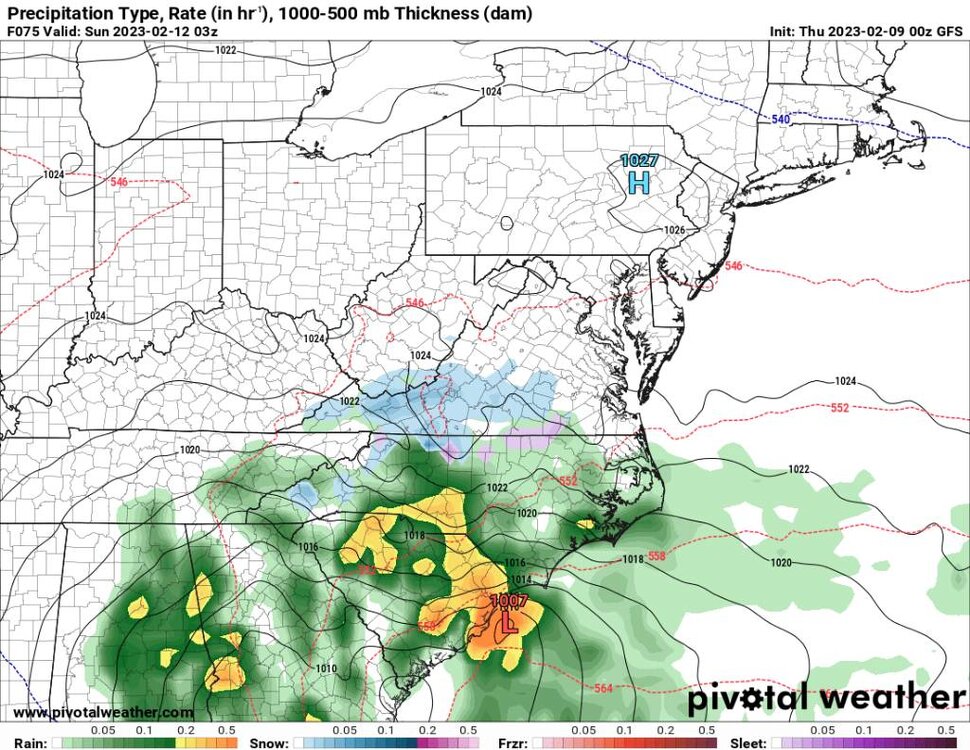
-
2022-2023 Fall/Winter Mountains Thread
Met1985 replied to BlueRidgeFolklore's topic in Southeastern States
The ull looks strung out on this run. It's way south again. -
2022-2023 Fall/Winter Mountains Thread
Met1985 replied to BlueRidgeFolklore's topic in Southeastern States
So far as I can tell this is going to be another weak solution. The ull doesn't look as stout at all. -
It's amazing seeing this ull dropping so low with basically no blocking in the usual places. I mean it happens but this is extremely rare.
-
2022-2023 Fall/Winter Mountains Thread
Met1985 replied to BlueRidgeFolklore's topic in Southeastern States
Well it's go time on the crazy gfs. Lets see what it spits out this go round. -
2022-2023 Fall/Winter Mountains Thread
Met1985 replied to BlueRidgeFolklore's topic in Southeastern States
That is a probably for sure.
.jpg.1e806fe7a35eb8e91af90b29e6882312.jpg)


.jpg.a8a2203fc528f044263c1598f7b2af00.jpg)
.jpg.22ba6bb4eb70ad62558706f3b3007f8f.jpg)
.jpg.fb76d89e905142bd144423b153fea66b.jpg)
.jpg.a8cf91d01ac11e1b5d1014e66be1eca1.jpg)
.jpg.10927a4513bdcc097596c9012d63cab5.jpg)
.jpg.798089de34ee756ae94c0c6b1b68d55a.jpg)