

Cashtown_Coop
-
Posts
3,380 -
Joined
-
Last visited
Content Type
Profiles
Blogs
Forums
American Weather
Media Demo
Store
Gallery
Posts posted by Cashtown_Coop
-
-
1 hour ago, bubbler86 said:
@Itstrainingtime, do not look at Goofus. :-). It has caved to the NAM/RGEM/EURO and is now much more amped with a 998 off the VA Capes but just looking at radar it is rain for much of Lanco. The gist of the GFS run should be that the LSV is about the get walloped and most guidance suggests even the SE corner comes away golden. Goofus jackspots @Cashtown_Coop

I hacked into the model
-
 2
2
-
-
1 minute ago, bubbler86 said:
I did not do a forecast for the board but I had I would have put you and I at 6 to 8. Eastern and southern Lanco 8 to 10. Everything I have seen shows us missing the very best of the rates that slobberknock far SE PA and NE MD. I think rates Lanco overcome surface Temps. That observer in upper strausberg may have to take a Strom off being number one (or even in the top 50 perrcent)
Nice Call. Upper Strasburg had a 11” snow depth on coop report yesterday morn. I’d like to hit 6.3” for this one to put me at 50” std, but my gut tells me this is a 4-5” event for us
-
1
-
-
4 minutes ago, AllWeather said:
Can't imagine much of a diurnal with virga in your spot. I'm more "worried" about eastern counties.
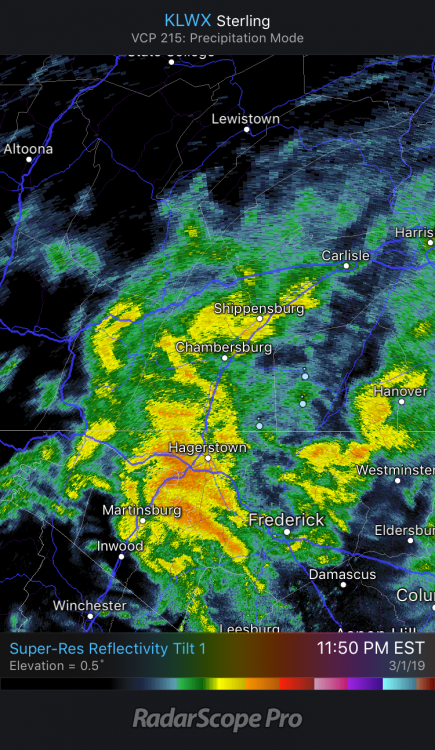
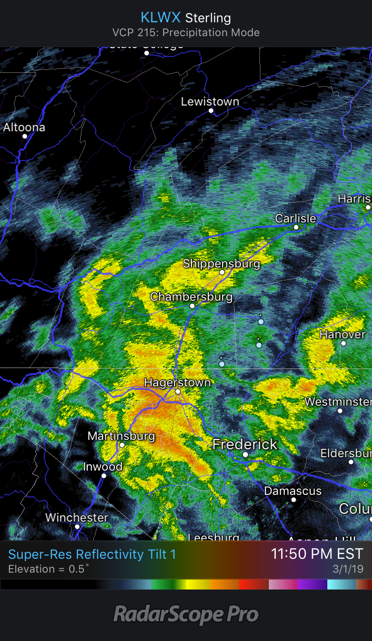
My fear out here is wasting the heavier rates before sunset. I believe Lanco County jackpots with the best rates after dark. Lastest Euro still targets that area with best qpf
-
33/23 with virga overhead. I don’t think temps go much higher out here
-
19 minutes ago, Blizzard of 93 said:
I’m Not sure if you saw this on the previous page. I’ve seen you reference here contacting CTP in the past.
Is there any way for you to contact them for an answer on this for us LSV folks ?
I’ll check into it.
-
3 minutes ago, anotherman said:
Kuchera

Us LSV guys can’t hate that look. 10-12” lollies tucked in a general 6-8” area. Thanks for posting this
-
Can anyone post the Kutchera?
-
Just now, anotherman said:

Nice to see the heavy axis back NW
-
1
-
-
Just now, Superstorm said:
I thought the dendrites were bigger in the 2nd event and they stacked higher.
.+1
-
3 minutes ago, CarlislePaWx said:
It was first week of Feb 2010. I got 27" from storm 1 followed by 13" storm 2 for 40" in less than 5 days. Not expecting to ever see that again in my lifetime...lol.
That’s it, you must have been fringed

-
5 minutes ago, CarlislePaWx said:
I melted down my 3.0" of snowfall from overnight and once again got a perfect 10:1 ratio with 0.30" of liquid. The weird thing is that both nights were 10:1 snow but last night's was way wetter than Thursday night's. I don't get that.
I'm sure this will change but this morning's 12Z HRRR (which ends at 0Z tomorrow evening) starts the storm as rain early tomorrow afternoon and for portions of the LSV keeps it rain until sunset. I think it has to do with precip rates in which it doesn't show the rain changing to snow until rates ramp up later in the afternoon.
Yeah same here with last 2 events. Almost copies of each other.
On TWC this morn, they had a video of someone driving through Carlisle under two rows of trees. It looked wintry with snow caked on the trees. Was that you cruising the city

-
3 minutes ago, Blizzard of 93 said:
I agree with you 100 %
There is a 6 inch snow storm on the way for at least the LSV tomorrow.
While I would love a foot plus event like most of us, I will take this event tomorrow all day.
MDT after tomorrow will be well above normal snow & near 40 inches for the season.
Also, when was the last time that we had 3 separate accumulating snows with 4 days?
What I am trying to say is that we should enjoy this memorable stretch of winter!
Right on. I have a chance for 12” of snow in 4 days. This is why I love the weather
-
2 minutes ago, paweather said:
Whatever it is 2,3, or 6 it is snow in March. Cold next week winter isn’t going away.
I feel ya. 7+ days with snow cover and several storms to track is great. Soon enough spring will hit, and this forum will go into hibernation until fall so let’s enjoy this period instead of worrying
-
Ended up with 3.2” from 0.30”of liquid. A near carbon copy of 24 hrs ago where I had 3.0” from 0.29” liquid.
-
Just hit 3.0”
still light snow and 29
-
M2.4”
mod snow
29F
-
1 minute ago, CarlislePaWx said:
Lol. The LanCo gradient literally flipped. This run seems to be following the other 0Z guidance sans the CMC. Still a little more time for adjustments maybe in our favor. Look how DC almost misses out completely even with the shift south. Amazing.
We’ve seen the south shift only trend north the last 24 hours so many times. That’s my feeling here. Also around 2” here. Still mod snow
-
Just now, CarlislePaWx said:
Incoming radar is a beaut with all greens heading my way...and slowly moving even. Wonder if it will get as heavy as last night?
Agreed. Nice band setting up
@bubbler86 doorsteep
-
Just now, Cashtown_Coop said:
I gave up on this one a little too early. I had nothing but sleet and freezing rain so I went to bed. Woke up to find a switch to snow and roads caved.
-
1
-
-
Just now, CarlislePaWx said:
What was your final from this morning?
3.0” from 0.29” liquid. Heaviest band was to my north
-
0.5” of new snow. Large flakes currently
-
14 minutes ago, bubbler86 said:
Ended up around 2.5" here but excessive blowing so had to measure in the most protected area. Driveway is mostly clear from being blown off.
I had 3.0” from 0.29” on my side. Wind remained calm for me
-
M2.5”
mod snow
25f
-
8 minutes ago, bubbler86 said:
First call for Friday and Friday night...to include both the inital wave and moisture and any coastal enhancement. The constant theme of the year...Cashtown, Mag and I come first. Going from memory on names and this is all for fun to help with forum involvement though these are my forecasts for now.
Bubbler @Cashtown_Coop @MAG5035...... 2-4"
@2001kx@CarlislePaWx @daxx @Blizzard of 93 @sauss06 @canderson @Itstrainingtime @pasnownut.......1-3"
Damn that much sweeeeet. I haven’t been tracking. I need 2.5” to hit 40” for season so I’ll root for that much

Central PA Feb/March 2019 Disco: More Snow In Our Future?
in Upstate New York/Pennsylvania
Posted
My fear from this morn. Wasted qpf.