

Cashtown_Coop
-
Posts
3,380 -
Joined
-
Last visited
Content Type
Profiles
Blogs
Forums
American Weather
Media Demo
Store
Gallery
Posts posted by Cashtown_Coop
-
-
1 hour ago, canderson said:
Don't worry we'll get a foot of snow on March 28 to make the average look like it was a fair winter.
This is exactly my thinking.
-
 2
2
-
-
10 minutes ago, Itstrainingtime said:
Lowest temp for the entire month of January in Lancaster was 25.
That's crazy.
Wow
-
13 minutes ago, Bubbler86 said:
They picked up exactly 5 more inches of precip than MDT did! MDT came in at a 1/2" deficit.
I had 2.59” so pretty close to MDT. Another eye popper is the state low temp for Jan was 8 in Crawford County but we did manage to get a 68 for highest temp in Washington county.
-
1
-
-
@MAG5035 To magnify your point on how much the laurels have struggled snowwise, Hidden Valley recorded 7.52” of precip for the month of January and Laurel Summit had 26.2” of snow for the month. These are both the highest recorded numbers in the state for January(state climatologist) With that much qpf available only yielding 26.2” of snow in that area, it’s truly been a struggle.
-
2
-
 1
1
-
-
5 minutes ago, Bubbler86 said:
The irony of you posting that HELL (am) is now a snow town was not lost on me.
I was trying lol. I don’t know the area very well but the exit off 30 is spelled Hallam and when I turn onto shoe house rd I noticed I was in Hellam twp.
-
I made Hallam a snow town. It had no choice but to follow me.
-
12 minutes ago, Blizzard of 93 said:
Seems right for our group….
@Cashtown_Coop jackpot !
LFG!!
-
 1
1
-
-
16 minutes ago, canderson said:
3” sound right - i eyeballed 2” on the sidewalk by my building at noon and we had a few more decent bands after that.
That’s what ….. oh never mind
-
2
-
-
2 minutes ago, Blizzard of 93 said:
MDT measured 3.0 today as of the 5 pm daily summary.

Not bad. No need to call in and complain
-
1
-
-
Just now, Bubbler86 said:
See, exactly what I said. The favorite pastime in Adams County is plowing (even if sparks) , drinking beer and going to Dennys! (as well as golfing in the winter).
we have snow in the grass but no more snow on any hard surfaces here. Down to about 1/4 to 1/2"
East of Gettysburg the snow really dropped off. Hanover was a coating. Dover had around 2” eyeballing. And no golfing tomorrow!!
-
2
-
1
-
-
50 minutes ago, Bubbler86 said:
We all need to pile into a van and move to Adams county. They have a shit load of winery's and high ABV beers on tap as well.
Still 3” on the ground. Just finished all my plowing. Time for a beer
-
2
-
-
4.7” snow. Over to sleet now. Off to Dover to make my run.
-
3
-
-
1 minute ago, DDweatherman said:
New band just popped up, great rates moving over us again.
When I talked to NWS they said 5” seemed likely this way
-
Just now, DDweatherman said:
What road is that? 16 is a mess and they’re doing some detours.
Carrolls Tract
-
-
Closing in on 4 inches
-
1 minute ago, Bubbler86 said:
That is 3" in one hour? My grass is not even covered.
Think it’s been 1 hour 20 min since first flakes
-
Just now, DDweatherman said:
Sweet pics, looks like 2” there at least
Yeah. Closing in on 3”
-
-
1 minute ago, Bubbler86 said:
Yea, a lot of schools still in. That is quite a bit of driving. Safe travels.
Oh it is. It’s 240 miles a day. Have to make it twice. More than I was looking for but it’s good extra money
-
2
-
-
-
1 minute ago, Bubbler86 said:
It was "snowing over us" for what seems like an hour or two. My temp dropped to 30 when it finally broke through.
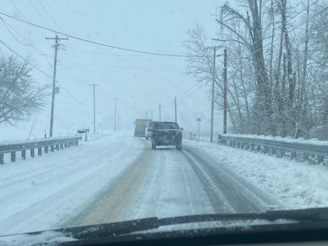
I haven’t been on the forum much recently due to picking up a part time job with the school district. I’m running LIU students around. My runs starts in Cashtown, goes to Hanover, up to Dover and finally last drop is Hallam exit of 30. I have the run today since York County schools never closed. Fun times ahead.
-
Just now, Itstrainingtime said:
That escalated quickly...
Yes indeed. One of the quickest starts I can remember.
-
2
-
-
3 minutes ago, Bubbler86 said:
Some people here (me included) enjoy the modelology of the hobby especially using the hourly models such as the HRRR to watch how it plays out.
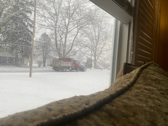
Plow just made the first pass here already. Grass is covered.
-
3
-

Central PA Winter 2022/2023
in Upstate New York/Pennsylvania
Posted
62 was the high for me.