

Amped
-
Posts
14,540 -
Joined
-
Last visited
Content Type
Profiles
Blogs
Forums
American Weather
Media Demo
Store
Gallery
Everything posted by Amped
-
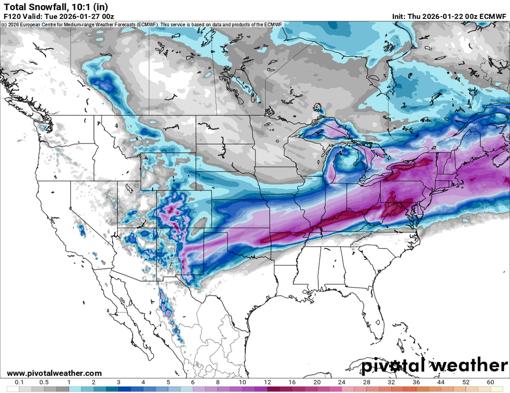
Gfs brewing something big down south at 216.
-
Just got an alert on my phone for a winter storm watch.
-
Huge snow swath. Starts right on the continental divide in New Mexico and goes all the way past eastern Maine
-
Cmc is my least favorite run so far. Ukmet and icon mix but at least they get a coastal transfer started early and track it well offshore. Cmc has the coastal too far west and not helping us.
-
I actually like this Icon run. The dryslot and the changeover hit at the same time north of I95, which means we dont waste a lot of heavy precip.
-

January 24-26: Miracle or Mirage JV/Banter Thread!
Amped replied to SnowenOutThere's topic in Mid Atlantic
The media is not picking up my storm name so I used AI to make a graphic for it. -
There is warm air all the way up to 700mb so the sleet line could be well north of there.
-
Ai gfs has something day 8-9
-
Great gfs run. Too bad its the outlier and its probably wrong.
-
Gfs is further east with the northern stream. Hopefully it stays that way.
-
Yeah clearly an error with the graphics, the transition zone is usually 70 miles. Could be bigger this time cause the waa is even higher up.
-
I like the 2 mile area of sleet between the snow and the freezing rain.
-
It can't show a bust if it doesn't run.
-
That jackpot went from Virginia Beach to Syracuse,NY fast.
-
Reminder, the pdii and the blizzard of 96 mixed with sleet along i95.
-
More precip than the 12z euro even had.
-
Its going to move into WV because there's mountains there. Just hope it's weak. A 1012mb low will easily be dominated by the cad and the coastal.
-
Verbatim its much better than a supressed weak sauce run. The trend is concerning however.
-
Bothe the gfs and the cmc build heights rapidly over the east coast and se canada from 84-102hrs. It went from slightly more risging to a lot more ridging fast. Thats what caused the shift.
-
Cmc coming north too. Party is on.
-
Gfs has a lot more snow from OK to KY than it did in prior runs.
-
Gfs is an ass hair further west with the northern stream and higher with heights ahead, so probably coming north.
-
Given the wind trajectory and the northern stream, I think Boston will pull it off. Hard to believe the CCB is just gonna dry up when it gets to New England like models are showing. Nevermind Icon does show 12" for Boston.
-
Icon with higher heights across the southeast as well. Probably coming north unless something goes wonky.
-
If it makes you laugh when you picture a news anchor saying it, and has a little bit to do with the storm, then its a good name.


