

HighStakes
-
Posts
4,528 -
Joined
-
Last visited
Content Type
Profiles
Blogs
Forums
American Weather
Media Demo
Store
Gallery
Everything posted by HighStakes
-
I was in Hampstead all morning. Very heavy snow at times and roads were terrible. solid 2-3 there maybe even a bit more in spots. Not as much when I got home. Looks to be 1.5 or so.
-
Stuck at 25.
-
There was that crazy inverted trough deal in early February 2009 that gave localized areas around Lancaster PA 8-9 inches and only light amount just miles away.
-
When are you going to give it up? Your constant griping is painfully ignorant.
-
12/31-1/1 Possible Snow Showers/Squalls to Start 2026
HighStakes replied to bncho's topic in Mid Atlantic
Actually after the initial heavy snow burst it continued to snow until 6 a.m. It was a solid squall but not as impressive as the one that came through in January 2020 the following morning of the only snowfall we had that year. That squall was the highlight of what was just an awful year. We got about 5 inches the day before then squall put down 2 inches in 40 minutes the following morning. It was a total whiteout. Attached is a picture of that morning during the height of the squall.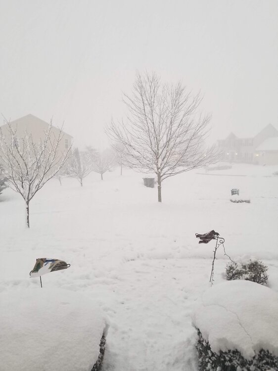
- 161 replies
-
- 13
-

-
1/1: 1.0 Total: 5.5 wasn't quite an inch but it was more than .5. Since we had a couple other dustings that produced a few tenths that I didn't record I'm calling this one an inch
-
12/31-1/1 Possible Snow Showers/Squalls to Start 2026
HighStakes replied to bncho's topic in Mid Atlantic
Started here. Strong winds, 1/4 mike visibility and S++. -
Getting really bad now. Everything has a solid coating of ice.
-
Same here.
-
Light snow with a quick dusting.
-
Devastating loss for NE. Control line of scrimmage and need to run efficiently and control their running game. Good chance to win next week. If we're fortunate enough win then we have legitimate momentum. Still a longshot but a shot no less.
-
12/13-12/14: 4.5
-
4.5 total. Temp down to 22.
-
Started 30 minutes ago as all snow!
-
Youth lol.
-
Take a break for a couple hours. You'll be ok!
-
This is turning into a pretty serious event especially for mid-December. This is the opposite of what we usually see occur. As we get closer the snow amounts keep increasing and the cold shot is looking stronger behind the snow. 3-6 inches followed by wind and teens is quite impressive. Low teens Monday morning then highs only in the 20's and flurries likely.
-
8 is the low so far.
-
Frederick, Carroll, Baltimore, and Harford Counties Area Discussion
HighStakes replied to Interstate's topic in Mid Atlantic
No comment. Lol -
Very light snow with slightest of dustings.
-
A few random flurries here. Pictures look nice from those getting snow.
-
We had two 7 plus inches storms in 2020/2021 here. March 2018 also.
-
3-6 is warning Criteria! Lol. I think you went a little conservative I have it at 4-8.
-
Absolutely horrendous!
-
Still quite a difference in precip. amounts. GFS advertising an inch of liquid north of 70 and Euro about .60. There are some things to really like with this system if you north and west of the beltways with some elevation. Maybe a good old fashioned 5-7 that ends in drizzle. Euro 850's and thicknesses and even surface temps look really good. GFS only a bit warmer. I would think any moderate to heavy precip is all snow.


