LVblizzard
-
Posts
4,900 -
Joined
-
Last visited
Content Type
Profiles
Blogs
Forums
American Weather
Media Demo
Store
Gallery
Everything posted by LVblizzard
-
E PA/NJ/DE Winter 2025-26 Obs/Discussion
LVblizzard replied to LVblizzard's topic in Philadelphia Region
DT has some kind of weird love affair with that model. Every forecast he puts out essentially mirrors what it shows. -
E PA/NJ/DE Winter 2025-26 Obs/Discussion
LVblizzard replied to LVblizzard's topic in Philadelphia Region
The GFS/GEFS were consistently too far south and east with the storm 3 weeks ago. -
E PA/NJ/DE Winter 2025-26 Obs/Discussion
LVblizzard replied to LVblizzard's topic in Philadelphia Region
The sun angle is doing work this week. There is a bare spot in my yard, first actual grass I’ve seen in about a month. Snowpack is now dwindling by about an inch or two per day. -
E PA/NJ/DE Winter 2025-26 Obs/Discussion
LVblizzard replied to LVblizzard's topic in Philadelphia Region
If you live and die by individual model runs sure. -
E PA/NJ/DE Winter 2025-26 Obs/Discussion
LVblizzard replied to LVblizzard's topic in Philadelphia Region
The answer is no. It misses again. -
I remember for the storm 3 weeks ago, when all the other models were trending north, the GFS had a couple of runs where it was a disjointed mess and stayed mostly south. This was just 4 days out. Obviously that didn’t verify.
-
E PA/NJ/DE Winter 2025-26 Obs/Discussion
LVblizzard replied to LVblizzard's topic in Philadelphia Region
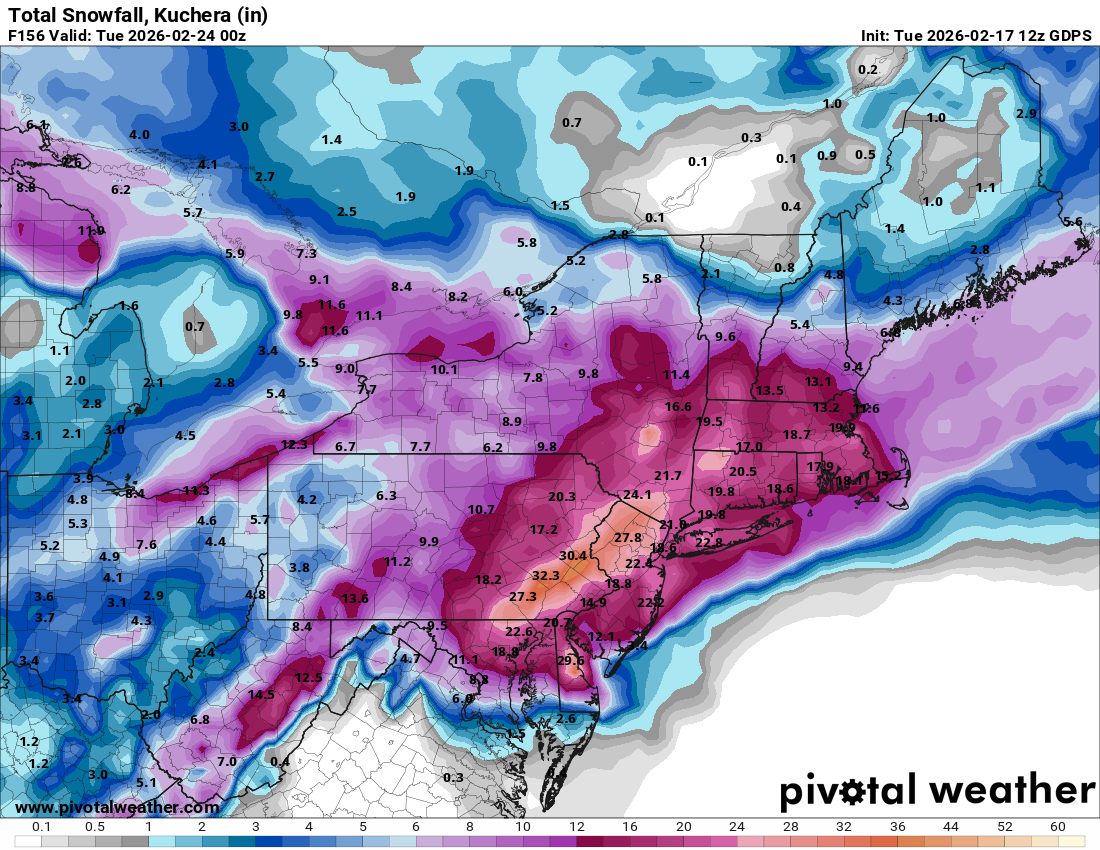
Snow map is absolutely bonkers. This would exceed 1996 and rival 2016 in the Lehigh Valley.
-
Early Monday morning 2/16 last minute event OBS/Discussion
LVblizzard replied to The Iceman's topic in Philadelphia Region
Nothing is left from last night. Classic late winter slop event where the sun angle melts everything pretty much immediately. -
E PA/NJ/DE Winter 2025-26 Obs/Discussion
LVblizzard replied to LVblizzard's topic in Philadelphia Region
18z Euro at least has the storm off the coast which it didn’t have at 12z. Progress. -
E PA/NJ/DE Winter 2025-26 Obs/Discussion
LVblizzard replied to LVblizzard's topic in Philadelphia Region
The KDIX outage is a bit concerning. Went offline 11 days ago and the latest message says they were unable to troubleshoot. Thank god we have TPHL as a backup even if it’s lower resolution. -
Why are we even talking about starting a thread for a storm chance a week away? There is nowhere near enough agreement with the models to warrant one. This could easily turn into an apps runner by tomorrow or Wednesday.
-
E PA/NJ/DE Winter 2025-26 Obs/Discussion
LVblizzard replied to LVblizzard's topic in Philadelphia Region
Being in the bullseye 7 days out rarely works out with this type of setup. This is more likely than not to turn into a mix or rain event IMO. -
Early Monday morning 2/16 last minute event OBS/Discussion
LVblizzard replied to The Iceman's topic in Philadelphia Region
About an inch here? I think? Can't really tell because pavement measurements aren't super reliable with this type of storm, and every other surface is still covered in snow. Still snowing lightly, I don't think we'll get to 2 inches. -
E PA/NJ/DE Winter 2025-26 Obs/Discussion
LVblizzard replied to LVblizzard's topic in Philadelphia Region
Sigh…I will take my 1-2” tonight and like it. It just hurts a little knowing how close this was to something more significant. -
E PA/NJ/DE Winter 2025-26 Obs/Discussion
LVblizzard replied to LVblizzard's topic in Philadelphia Region
I’m not sure I can remember a storm threat quite like this. It’s such an unusual setup, far from what we typically see. Just crazy how such a small change at H5 in the first 12-24 hours leads to huge differences only a day later. -
E PA/NJ/DE Winter 2025-26 Obs/Discussion
LVblizzard replied to LVblizzard's topic in Philadelphia Region
GFS just went full weenie. Over half a foot for most of us. What on earth is going on? -
E PA/NJ/DE Winter 2025-26 Obs/Discussion
LVblizzard replied to LVblizzard's topic in Philadelphia Region
When the GFS is on its own, it’s wrong more often than not. -
E PA/NJ/DE Winter 2025-26 Obs/Discussion
LVblizzard replied to LVblizzard's topic in Philadelphia Region
Just when it looked like all hope was lost, the Euro comes in with a significant storm for Sunday night. Widespread 12-16” of snow north and west of Philly. -
E PA/NJ/DE Winter 2025-26 Obs/Discussion
LVblizzard replied to LVblizzard's topic in Philadelphia Region
If this is it for prolonged cold and lots of snow chances, I’m glad we had a front loaded winter for once. I’m fine with an early spring with the kind of winter we had in December and January. -
E PA/NJ/DE Winter 2025-26 Obs/Discussion
LVblizzard replied to LVblizzard's topic in Philadelphia Region
The Sun-Mon storm looks more like a thread the needle type setup to me. We need enough cold air that precip remains all or mostly snow, but too strong of a cold air press suppresses the storm to the south. It's certainly possible but I don't think the chances are super high. Better chance of something north of I-78 IMO. -
E PA/NJ/DE Winter 2025-26 Obs/Discussion
LVblizzard replied to LVblizzard's topic in Philadelphia Region
Only weak echoes here on the radar (using TPHL since KDIX is down) yet we’ve had a steady light snow for the past hour. Dusting on the ground. -
E PA/NJ/DE Winter 2025-26 Obs/Discussion
LVblizzard replied to LVblizzard's topic in Philadelphia Region
Yep same here. Would be fitting to get a huge storm on the one weekend I absolutely do not want one. -
E PA/NJ/DE Winter 2025-26 Obs/Discussion
LVblizzard replied to LVblizzard's topic in Philadelphia Region
NAM got better for tomorrow too. Drops 1-3” rather than the C-1” it’s been showing. -
E PA/NJ/DE Winter 2025-26 Obs/Discussion
LVblizzard replied to LVblizzard's topic in Philadelphia Region
This snowpack isn’t going anywhere anytime soon, even in sunnier areas. We got about a foot in Allentown last week and we still have the vast majority of it. Would really like some minor to moderate events in the next week or two to make sure we keep the snow on the ground for the rest of meteorological winter. -
E PA/NJ/DE Winter 2025-26 Obs/Discussion
LVblizzard replied to LVblizzard's topic in Philadelphia Region
Next Wed-Thurs has some potential. Probably nothing big but I could see a widespread 2-4” or 3-6” event.