

LVblizzard
-
Posts
4,960 -
Joined
-
Last visited
Content Type
Profiles
Blogs
Forums
American Weather
Media Demo
Store
Gallery
Everything posted by LVblizzard
-
January 25-26 Winter Storm Potential
LVblizzard replied to Ralph Wiggum's topic in Philadelphia Region
Meanwhile the NAM gets plain rain to Philly. -
January 25-26 Winter Storm Potential
LVblizzard replied to Ralph Wiggum's topic in Philadelphia Region
It’s the NAM/RRFS vs. every other meso. Very intrigued to see how this plays out. I reduced my final call for the Lehigh Valley to 8-14” and I’m very confident in that right now. -
January 25-26 Winter Storm Potential
LVblizzard replied to Ralph Wiggum's topic in Philadelphia Region
Ehhh we got them back in 2021. I think it’s even now. -
January 25-26 Winter Storm Potential
LVblizzard replied to Ralph Wiggum's topic in Philadelphia Region
I will not fall for the HRRR again I will not fall for the HRRR again I will not fall for the HRRR again I will not fall for the HRRR again I will not fall for the HRRR again I will not fall for the HRRR again -
Extreme Cold, Snow & Sleet: SECS 1/24 - 1/26
LVblizzard replied to TriPol's topic in New York City Metro
Hate to say it but it’s pretty useless to look at globals this close to the storm. Mesos and CAMs are more reliable at this range. -
January 25-26 Winter Storm Potential
LVblizzard replied to Ralph Wiggum's topic in Philadelphia Region
NAM and RRFS are on their own with the extreme mid level warm air surge. None of the other globals or mesos agree with pushing sleet to the Poconos. -
January 25-26 Winter Storm Potential
LVblizzard replied to Ralph Wiggum's topic in Philadelphia Region
Euro just came in with an absolute nuke.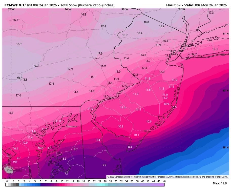
-
Jan 24-26 Weekend Snow and Sleetfest Model Thread Part Tres
LVblizzard replied to H2O's topic in Mid Atlantic
That too…reflectivity is bright and CC shows a clear boundary from roughly Ada to McAlester. Still means the NAM was too warm which has me injecting some hopium. -
Jan 24-26 Weekend Snow and Sleetfest Model Thread Part Tres
LVblizzard replied to H2O's topic in Mid Atlantic
Look at mPING as it relies on actual observations, not the colors on radar maps. It currently has sleet up to Ada, OK, right in line with the Euro and HRRR. It does appear the NAM was too warm at the mid levels, though, as it had sleet up to I-40 where it’s currently all snow. -
January 25-26 Winter Storm Potential
LVblizzard replied to Ralph Wiggum's topic in Philadelphia Region
It’s getting that sweet recon data. But the GFS is still the GFS. It’s more likely than not to let us down in the end. I’ve seen this movie too many times before. -
Extreme Cold, Snow & Sleet: SECS 1/24 - 1/26
LVblizzard replied to TriPol's topic in New York City Metro
That includes sleet. The WB maps show a disastrous outcome with sleet getting well north of I-80 and just 6” for the city. -
January 25-26 Winter Storm Potential
LVblizzard replied to Ralph Wiggum's topic in Philadelphia Region
RRFS gets the sleet line to Scranton. Meanwhile none of the other mesos (minus the NAM) get it past the Lehigh Valley. Quite the battle we have here. -
January 25-26 Winter Storm Potential
LVblizzard replied to Ralph Wiggum's topic in Philadelphia Region
Wow so basically no melting this week. Yeah this will stick around for awhile. -
January 25-26 Winter Storm Potential
LVblizzard replied to Ralph Wiggum's topic in Philadelphia Region
You’re like 15 miles south of me. How much is still left there? I’ve been away since Monday. -
January 25-26 Winter Storm Potential
LVblizzard replied to Ralph Wiggum's topic in Philadelphia Region
I’m literally 1/4 mile south of I-78. Good thing weather doesn’t follow interstate highways like that! -
January 25-26 Winter Storm Potential
LVblizzard replied to Ralph Wiggum's topic in Philadelphia Region
3km NAM literally has my house right on the line for hours. Route 22 is basically the dividing line between a big storm and a bust. -
January 25-26 Winter Storm Potential
LVblizzard replied to Ralph Wiggum's topic in Philadelphia Region
And it didn’t follow…still torches the mid levels. 6-10” for the area then sleet. Just 20-25 miles more south with that line and we’re back though. This isn’t over by any means. -
Jan 24-26 Weekend Snow and Sleetfest Model Thread Part Tres
LVblizzard replied to H2O's topic in Mid Atlantic
HRRR has a warm bias at the surface…which is strange because it’s often too cold in the mid levels. -
January 25-26 Winter Storm Potential
LVblizzard replied to Ralph Wiggum's topic in Philadelphia Region
HRRR doesn’t get the mix line past the Lehigh Valley. Stalls it at southern Lehigh County then retreats towards the turnpike. We’ll see if the NAM follows. -
January 25-26 Winter Storm Potential
LVblizzard replied to Ralph Wiggum's topic in Philadelphia Region
That’s all snow here so I’d be pretty happy with that. I don’t mind changing over to sleet as long as we get dumped on with snow first. -
Extreme Cold, Snow & Sleet: SECS 1/24 - 1/26
LVblizzard replied to TriPol's topic in New York City Metro
Part of me thinks he’s just bitter that the storm trended to a sleet/ice storm for his area and now he’s rooting on an enormous north trend to spite the rest of I-95 too. -
January 25-26 Winter Storm Potential
LVblizzard replied to Ralph Wiggum's topic in Philadelphia Region
My call is already lower than the 12-18” that the other two big pages (EPAWA and LVWA) have. Getting just 6” would be a massive failure. -
January 25-26 Winter Storm Potential
LVblizzard replied to Ralph Wiggum's topic in Philadelphia Region
Went 10-16” for the Lehigh Valley on my page yesterday. Sticking to that tonight. We cannot have another jump north after that 18z suite though. That would cause me to really rethink things and I HATE busting high. -
January 25-26 Winter Storm Potential
LVblizzard replied to Ralph Wiggum's topic in Philadelphia Region
Euro isn’t bad at all. Actually bumps up totals a bit for the Philly area. However the LV/Poconos don’t get as big of a thump. -
New York City 11 Boston 17 Philadelphia 9 Washington DC 8 Hartford 16 Albany 16


