LVblizzard
-
Posts
4,960 -
Joined
-
Last visited
Content Type
Profiles
Blogs
Forums
American Weather
Media Demo
Store
Gallery
Everything posted by LVblizzard
-
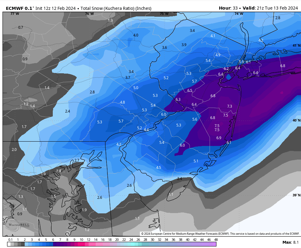
I went fairly aggressive on my page after that Euro run. 8-16” for the Lehigh Valley. At this point I start to trust mesos more than globals, but that run was the reassurance I needed that we’re probably getting something big.
-
Just about a full cave on the Euro. 8-12” region-wide with some areas of 16” near the shore.
-
I’d up it to 6-12” for the LV. I think we get into the heavy banding for at least a few hours tomorrow night. I don’t buy the models that completely miss us with it.
-
For them, yes. For this subforum it’s essentially the same.
-
I was admittedly a little concerned last night after seeing the Euro…looks like the short range and meso models are easing my worries this morning.
-
Sorry but the NAM doesn’t make any sense to me. There’s no reason it should start noticeably worse and then go and do that. It seems like one of those classic NAM runs that has no chance of verifying but looks great through weenie goggles.
-
We’re at the point where we’re running out of time for any significant trends. It’s likely that the GFS is too amped and the Euro is too progressive. Blend them together and it’s still a warning level event for our area. That’s enough model watching for me tonight. I need sleep.
-
Look at hours 45 and 48. The run recovers and gives all of us heavy snow.
-
NAM recovers very nicely at hour 45. 3km is looking decent too.
-
Let’s flip the script here…if all the models were showing a miss/graze and the Euro was the only one showing a snowstorm, which would you go with? The rest of the models won when this scenario happened with Juno in 2015.
-
Not as disgustingly bad as the OP run. But still. Not what you want to see.
-
In case anyone is wondering about a situation in which the Euro failed spectacularly in the short range. This is from 2 years ago.

-
Look no further than a week ago. GFS had 6 inches, RGEM had nothing. End result was somewhere in the middle.
-
Euro is Boxing Day all over again for the Lehigh Valley. Forecast was up to a foot, we only got 2 inches. It’s the first storm that comes to mind when I think of bad busts. I’m too young to remember 2001.
-
Euro is an absolute disaster. Just 2-4” except by the shore. It has a screw zone of just an inch directly over Allentown. No bueno.
-
E PA/NJ/DE Winter 2025-26 Obs/Discussion
LVblizzard replied to LVblizzard's topic in Philadelphia Region
Fog is pretty crazy in some spots tonight. I can barely see 1/10 mile at times. -
1-2 feet throughout the area this run with lollies to 30”. Just insane!
-
That backside vort keeps getting closer to phasing into this thing. If that happens this turns into a BECS.
-
It might on Sunday afternoon with marginal temps. But once the heavy banding arrives Sunday night it’s game on.
-
So did the RRFS.
-
Finally got a break from tonight’s DoorDash shift to look at the models. What in the actual f**k is going on??? How has this gone from a high end advisory event to a HECS in 24 hours?
-
18z Euro continued its west trend. It’s not like the GFS but it gets warning criteria snow back to Philly and the burbs.
-
I went fairly conservative with my first call on my page. I have 4-8" for the Lehigh Valley for now but confidence is pretty low. This has too many similarities to Boxing Day for my liking and that was a huge bust here. It'll be harder for this one to badly bust like that, but at this point I do think most heavy banding stays fairly close to I-95.
-
Are y’all ready to get NAMed? 18z looks like it’ll make an attempt at it.
-
March 2001 shifted like 200 miles north at the last minute. No chance of that happening this time around. A miss to the east is the bust scenario in this case.