LVblizzard
-
Posts
4,968 -
Joined
-
Last visited
Content Type
Profiles
Blogs
Forums
American Weather
Media Demo
Store
Gallery
Everything posted by LVblizzard
-
E PA/NJ/DE Summer 2026 Obs/Discussion
LVblizzard replied to PhiEaglesfan712's topic in Philadelphia Region
That line coming through Lancaster looks nasty. Wouldn’t be surprised if it leaves a trail of wind damage and even a tornado or two. -
E PA/NJ/DE Summer 2026 Obs/Discussion
LVblizzard replied to PhiEaglesfan712's topic in Philadelphia Region
Decent storm ongoing right now. I was surprised to hear thunder because I checked the radar an hour ago and it looked like the storms to the west were petering out. Apparently not. -
E PA/NJ/DE Summer 2026 Obs/Discussion
LVblizzard replied to PhiEaglesfan712's topic in Philadelphia Region
Total screwjob for most of SE PA today. One line missed to the north and another line missed to the south. Sigh… -
E PA/NJ/DE Summer 2026 Obs/Discussion
LVblizzard replied to PhiEaglesfan712's topic in Philadelphia Region
Insane CG barrage right now just west of Allentown. Best lightning I’ve seen all year. -
E PA/NJ/DE Summer 2026 Obs/Discussion
LVblizzard replied to PhiEaglesfan712's topic in Philadelphia Region
Decent light show to the north and south this evening. Just wish it would have hit the Lehigh Valley instead of going around us. -
E PA/NJ/DE Summer 2026 Obs/Discussion
LVblizzard replied to PhiEaglesfan712's topic in Philadelphia Region
I will definitely be doing some chasing out there! It’s actually a big part of why I’m moving, so I can be a short drive from the plains of eastern CO. They get some nasty supercells out there and a decent amount of tornadoes. -
E PA/NJ/DE Summer 2026 Obs/Discussion
LVblizzard replied to PhiEaglesfan712's topic in Philadelphia Region
Yes. I worked hard to organically build a community of 14k followers. I’m not giving that up. -
E PA/NJ/DE Summer 2026 Obs/Discussion
LVblizzard replied to PhiEaglesfan712's topic in Philadelphia Region
Here comes the humidity. It was comfortable here 2 hours ago…not so much now. Hopefully we get some rain later to cool us down. This will be my last full week in the Lehigh Valley for awhile - possibly ever? I’m moving to Denver in a week and a half because it’s somewhere I’ve always wanted to live and I’m now in a position to give it a try. It gets hot out there sometimes but it’s a dry heat. “Humid” there is a DP of 60. It’s going to be quite the adjustment but I’m looking forward to living in a place with such volatile weather. -
E PA/NJ/DE Summer 2026 Obs/Discussion
LVblizzard replied to PhiEaglesfan712's topic in Philadelphia Region
That cell over Allentown tried to go into tornado making mode. I was getting gas at Costco and I noticed some pretty intense rotation, despite radar not really showing it. Didn’t see any funnels but the motion in the clouds was pretty crazy. -
E PA/NJ/DE Summer 2026 Obs/Discussion
LVblizzard replied to PhiEaglesfan712's topic in Philadelphia Region
There’s been near constant thunder here for over 3 hours. Our only break was an hour ago when the first storm left and the second one hadn’t formed yet. -
E PA/NJ/DE Summer 2026 Obs/Discussion
LVblizzard replied to PhiEaglesfan712's topic in Philadelphia Region
Yeah this is a tough area to chase in. Might not matter though…that little supercell is making a beeline directly towards me. Hearing lots of distant thunder. If it does try to tornado it’ll happen very close to my house, likely just south. -
E PA/NJ/DE Summer 2026 Obs/Discussion
LVblizzard replied to PhiEaglesfan712's topic in Philadelphia Region
Figures…the one day my car is in the shop is the one that has tornadic supercells everywhere. Would have loved to chase today. -
E PA/NJ/DE Summer 2026 Obs/Discussion
LVblizzard replied to PhiEaglesfan712's topic in Philadelphia Region
Some clearing is showing up in southern PA and expanding ENE. Today is still game on from the Lehigh Valley southward.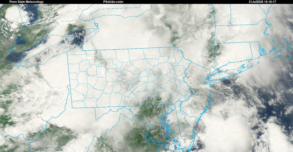
-
E PA/NJ/DE Summer 2026 Obs/Discussion
LVblizzard replied to PhiEaglesfan712's topic in Philadelphia Region
The HRRR has been adamant about this early activity and it still has severe storms around later. I don’t think it fully kills the severe threat…it does make it a little tougher though. -
E PA/NJ/DE Summer 2026 Obs/Discussion
LVblizzard replied to PhiEaglesfan712's topic in Philadelphia Region
The NAM and HRRR look drastically different for Tuesday. The NAM has widely scattered storms in eastern PA while the main line stays in western PA and dissipates as it reaches this area. The HRRR plows a strong line of storms through the region on Tuesday evening. It’s a decent setup without as many fail modes as Saturday…but we still need things to come together the right way. It’s not easy to get a severe outbreak around here. -
E PA/NJ/DE Summer 2026 Obs/Discussion
LVblizzard replied to PhiEaglesfan712's topic in Philadelphia Region
That cold front feels nice. Windows are open to let in the less humid and non smoky air. Tuesday’s threat looks interesting…would be nice to make up for yesterday’s whiff around here. -
E PA/NJ/DE Summer 2026 Obs/Discussion
LVblizzard replied to PhiEaglesfan712's topic in Philadelphia Region
I have my eye on the stuff north of State College. If the Lehigh Valley is going to see any severe weather, it’ll be from that. If it can latch onto the warm front it might get pretty gnarly. -
E PA/NJ/DE Summer 2026 Obs/Discussion
LVblizzard replied to PhiEaglesfan712's topic in Philadelphia Region
Sun is starting to peek out in Lehigh County. A little quicker than I expected. Hopefully that little blob of rain out near Harrisburg either fizzles or passes to the south so the atmosphere can continue to destabilize. -
E PA/NJ/DE Summer 2026 Obs/Discussion
LVblizzard replied to PhiEaglesfan712's topic in Philadelphia Region
I’m liking Harrisburg to Lancaster to Philly for the best tornado potential today just based on where the warm front appears to be setting up. -
E PA/NJ/DE Summer 2026 Obs/Discussion
LVblizzard replied to PhiEaglesfan712's topic in Philadelphia Region
A lot less smoky out there today. I can even see some blue in the sky. Looking forward to this crap being gone by tomorrow afternoon. -
E PA/NJ/DE Summer 2026 Obs/Discussion
LVblizzard replied to PhiEaglesfan712's topic in Philadelphia Region
Storms juuuuust missed my place in the western suburbs of Allentown. The cool outflow feels nice at least. -
E PA/NJ/DE Summer 2026 Obs/Discussion
LVblizzard replied to PhiEaglesfan712's topic in Philadelphia Region
Some storms forming north of I-80 and moving southeast. One of them is severe warned. Let’s see how long they can hold together. -
E PA/NJ/DE Summer 2026 Obs/Discussion
LVblizzard replied to PhiEaglesfan712's topic in Philadelphia Region
Radar says this will happen today too. The cell over Schuylkill County looks to miss to the west. -
E PA/NJ/DE Summer 2026 Obs/Discussion
LVblizzard replied to PhiEaglesfan712's topic in Philadelphia Region
Enjoying having the windows down with a cool breeze today. It feels amazing. Hopefully we can get some more rain later too…preferably before 8 so the World Cup watch party in Bethlehem can stay outdoors. -
E PA/NJ/DE Summer 2026 Obs/Discussion
LVblizzard replied to PhiEaglesfan712's topic in Philadelphia Region
Interesting that they issued a heat advisory for today. I don’t think I’ve ever seen that here with a high in the 80s.