

LVblizzard
-
Posts
4,928 -
Joined
-
Last visited
Content Type
Profiles
Blogs
Forums
American Weather
Media Demo
Store
Gallery
Everything posted by LVblizzard
-
January 25-26 Winter Storm Potential
LVblizzard replied to Ralph Wiggum's topic in Philadelphia Region
Euro just came in with an absolute nuke.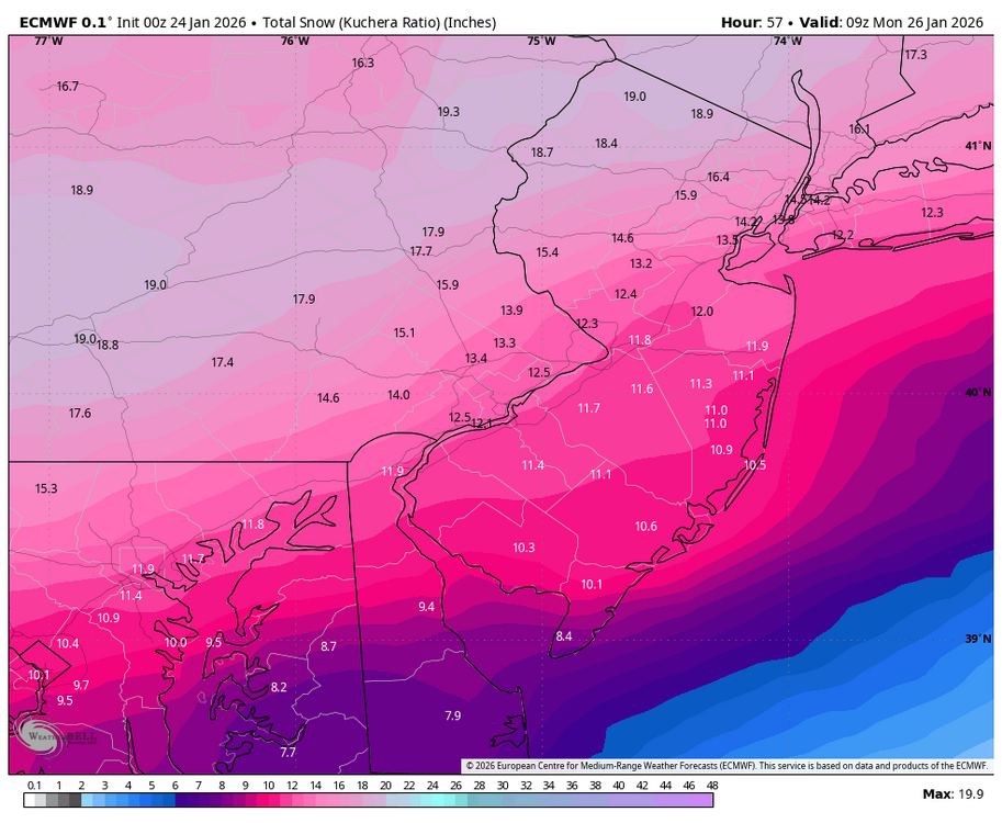
-
Jan 24-26 Weekend Snow and Sleetfest Model Thread Part Tres
LVblizzard replied to H2O's topic in Mid Atlantic
That too…reflectivity is bright and CC shows a clear boundary from roughly Ada to McAlester. Still means the NAM was too warm which has me injecting some hopium. -
Jan 24-26 Weekend Snow and Sleetfest Model Thread Part Tres
LVblizzard replied to H2O's topic in Mid Atlantic
Look at mPING as it relies on actual observations, not the colors on radar maps. It currently has sleet up to Ada, OK, right in line with the Euro and HRRR. It does appear the NAM was too warm at the mid levels, though, as it had sleet up to I-40 where it’s currently all snow. -
January 25-26 Winter Storm Potential
LVblizzard replied to Ralph Wiggum's topic in Philadelphia Region
It’s getting that sweet recon data. But the GFS is still the GFS. It’s more likely than not to let us down in the end. I’ve seen this movie too many times before. -
Extreme Cold, Snow & Sleet: SECS 1/24 - 1/26
LVblizzard replied to TriPol's topic in New York City Metro
That includes sleet. The WB maps show a disastrous outcome with sleet getting well north of I-80 and just 6” for the city. -
January 25-26 Winter Storm Potential
LVblizzard replied to Ralph Wiggum's topic in Philadelphia Region
RRFS gets the sleet line to Scranton. Meanwhile none of the other mesos (minus the NAM) get it past the Lehigh Valley. Quite the battle we have here. -
January 25-26 Winter Storm Potential
LVblizzard replied to Ralph Wiggum's topic in Philadelphia Region
Wow so basically no melting this week. Yeah this will stick around for awhile. -
January 25-26 Winter Storm Potential
LVblizzard replied to Ralph Wiggum's topic in Philadelphia Region
You’re like 15 miles south of me. How much is still left there? I’ve been away since Monday. -
January 25-26 Winter Storm Potential
LVblizzard replied to Ralph Wiggum's topic in Philadelphia Region
I’m literally 1/4 mile south of I-78. Good thing weather doesn’t follow interstate highways like that! -
January 25-26 Winter Storm Potential
LVblizzard replied to Ralph Wiggum's topic in Philadelphia Region
3km NAM literally has my house right on the line for hours. Route 22 is basically the dividing line between a big storm and a bust. -
January 25-26 Winter Storm Potential
LVblizzard replied to Ralph Wiggum's topic in Philadelphia Region
And it didn’t follow…still torches the mid levels. 6-10” for the area then sleet. Just 20-25 miles more south with that line and we’re back though. This isn’t over by any means. -
Jan 24-26 Weekend Snow and Sleetfest Model Thread Part Tres
LVblizzard replied to H2O's topic in Mid Atlantic
HRRR has a warm bias at the surface…which is strange because it’s often too cold in the mid levels. -
January 25-26 Winter Storm Potential
LVblizzard replied to Ralph Wiggum's topic in Philadelphia Region
HRRR doesn’t get the mix line past the Lehigh Valley. Stalls it at southern Lehigh County then retreats towards the turnpike. We’ll see if the NAM follows. -
January 25-26 Winter Storm Potential
LVblizzard replied to Ralph Wiggum's topic in Philadelphia Region
That’s all snow here so I’d be pretty happy with that. I don’t mind changing over to sleet as long as we get dumped on with snow first. -
Extreme Cold, Snow & Sleet: SECS 1/24 - 1/26
LVblizzard replied to TriPol's topic in New York City Metro
Part of me thinks he’s just bitter that the storm trended to a sleet/ice storm for his area and now he’s rooting on an enormous north trend to spite the rest of I-95 too. -
January 25-26 Winter Storm Potential
LVblizzard replied to Ralph Wiggum's topic in Philadelphia Region
My call is already lower than the 12-18” that the other two big pages (EPAWA and LVWA) have. Getting just 6” would be a massive failure. -
January 25-26 Winter Storm Potential
LVblizzard replied to Ralph Wiggum's topic in Philadelphia Region
Went 10-16” for the Lehigh Valley on my page yesterday. Sticking to that tonight. We cannot have another jump north after that 18z suite though. That would cause me to really rethink things and I HATE busting high. -
January 25-26 Winter Storm Potential
LVblizzard replied to Ralph Wiggum's topic in Philadelphia Region
Euro isn’t bad at all. Actually bumps up totals a bit for the Philly area. However the LV/Poconos don’t get as big of a thump. -
New York City 11 Boston 17 Philadelphia 9 Washington DC 8 Hartford 16 Albany 16
-
Extreme Cold, Snow & Sleet: SECS 1/24 - 1/26
LVblizzard replied to TriPol's topic in New York City Metro
Notice the trend of the weaker primary…that may end up making the difference for a lot of people. -
January 25-26 Winter Storm Potential
LVblizzard replied to Ralph Wiggum's topic in Philadelphia Region
Northern extent of the mix line comes down to two things: 1. Snowfall rates - heavier snow = slower progression northward 2. Formation of the secondary low - models have been killing off the primary sooner since last night which is what we want to see for a snowier solution -
January 24-26: Miracle or Mirage JV/Banter Thread!
LVblizzard replied to SnowenOutThere's topic in Mid Atlantic
Sharp fall-line cutoffs scream “fake precision” At 3-km resolution, a knife-edge cutoff near the fall line at Day 2–2.5 usually means: Convective or feedback-driven thermal noise Poor handling of ageostrophic ascent CAD erosion happening too abruptly Real storms: Transition gradually Evolve over multiple cycles Rarely stop snow exactly at the fall line at this lead time FV3 matching NWS matters — but why matters more It’s not just that FV3 agrees with NWS — it’s what it agrees on: Cold column integrity Broad ascent Synoptic-scale snow shield That alignment tells you: The conceptual model is consistent across guidance. That’s far more important than any single snowfall number. What’s likely happening physically Most likely evolution given current signals: CAD holds longer than NAM suggests Warm nose (if it arrives) is: Later Weaker South/west of DC Snow extends well south of the fall line initially Any mix issues become: Late-stage South-focused Elevation-dependent NAM is probably correct that warm air exists aloft eventually FV3 is probably correct on timing and impact How forecasters would weight this right now At Hour 40–60: Reject the NAM snowfall cliff Flag the NAM warm nose as a risk, not an outcome Lean FV3 for: Snow extent Cold-air durability Early & mid-storm evolution If future NAM runs: Delay the warm nose Soften the cutoff Trend colder That’s convergence toward FV3, not the other way around. Bottom line (plain language) The NAM is likely too warm, too fast, and too sharp The FV3/NWS solution is meteorologically cleaner At this range, widespread snow is the higher-probability outcome Mixing concerns are real but premature This is exactly the kind of setup where: NAM scares you early FV3 ends up closer on the big picture If you want, next we can: Walk through what would need to change for the NAM solution to win Identify the specific upstream feature that decides this Compare this setup to Jan 2016 / Jan 2018 / Jan 2000-style cases Just tell me where you want to go next. So ChatGPT is a weenie? Who would have guessed lol. -
January 25-26 Winter Storm Potential
LVblizzard replied to Ralph Wiggum's topic in Philadelphia Region
3km NAM does the same thing with stalling the mix line, except it does it like 20 miles north right along I-78. -
January 25-26 Winter Storm Potential
LVblizzard replied to Ralph Wiggum's topic in Philadelphia Region
It actually starts out warmer. Earlier in the run I was like welp here we go again. But that sleet line just stalls on Sunday afternoon. It will come down to rates but also the development of the secondary low. -
January 25-26 Winter Storm Potential
LVblizzard replied to Ralph Wiggum's topic in Philadelphia Region
12z NAM is substantially colder north of Philly. All snow for I-78 north. Jackpot zone of 16-20” for the LV and Poconos.


