LVblizzard
-
Posts
4,947 -
Joined
-
Last visited
Content Type
Profiles
Blogs
Forums
American Weather
Media Demo
Store
Gallery
Everything posted by LVblizzard
-
Saturday night/Sunday 12/13-12/14 Jawn
LVblizzard replied to Ralph Wiggum's topic in Philadelphia Region
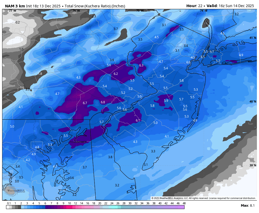
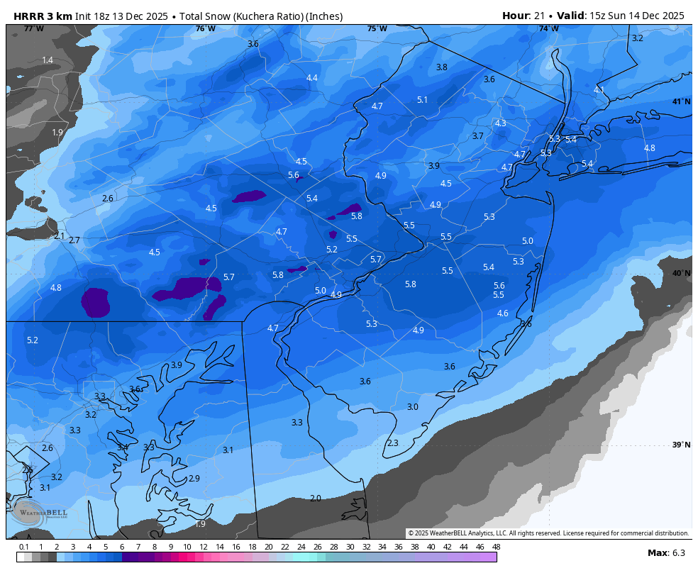
These mesos just keep beefing up totals. 19z HRRR is a widespread 5-7” with isolated 8” spots throughout SE PA, from Philly through the burbs up to the Lehigh Valley. My 2-4” call for the Allentown area might be too low, when at this time yesterday I was wondering if it would be too high! -
Saturday night/Sunday 12/13-12/14 Jawn
LVblizzard replied to Ralph Wiggum's topic in Philadelphia Region
We have just been NAM’d. 4-6” for most of us, jackpot zones of 6-8” scattered around SE PA.
-
Saturday night/Sunday 12/13-12/14 Jawn
LVblizzard replied to Ralph Wiggum's topic in Philadelphia Region
Very surprised they haven’t given a WWA to Carbon/Monroe counties. Models have brought some of the heavy banding into the Poconos. -
Saturday night/Sunday 12/13-12/14 Jawn
LVblizzard replied to Ralph Wiggum's topic in Philadelphia Region
18z HRRR would make everyone very happy.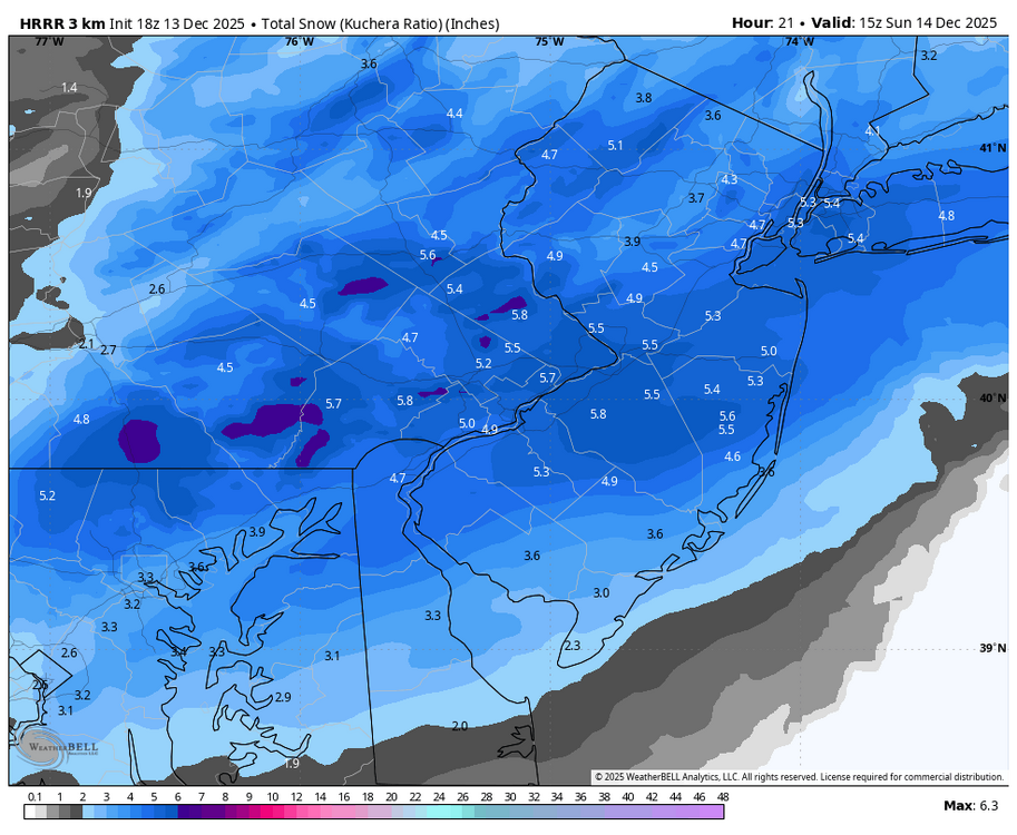
-
Saturday night/Sunday 12/13-12/14 Jawn
LVblizzard replied to Ralph Wiggum's topic in Philadelphia Region
Don’t mind it at all. I’m usually up till 2-3 am anyway…gonna enjoy the late night silence tonight with moderate fluffy snow falling. -
I wouldn’t worry about that too much. I’m in eastern PA and earlier this week we had an event that the HRRR said would be all or mostly rain. Instead my area got a nice C-2” event with some 3” spots.
-
Saturday night/Sunday 12/13-12/14 Jawn
LVblizzard replied to Ralph Wiggum's topic in Philadelphia Region
Not sure how much globals matter at this point, but the 12z GFS has finally fully caught on and has a nice solid 3-6” storm for this entire subforum. -
Saturday night/Sunday 12/13-12/14 Jawn
LVblizzard replied to Ralph Wiggum's topic in Philadelphia Region
The HRRR keeps getting more aggressive with the banding. 14z run that just came out has 3-4 hours of near 1”/hr rates along and just south of I-78. -
Saturday night/Sunday 12/13-12/14 Jawn
LVblizzard replied to Ralph Wiggum's topic in Philadelphia Region
I went with 2-4” yesterday for our area and I’m making my final call tomorrow morning. I’m pretty sure I’ll be sticking with that. I expect closer to 2” for most of the area but I can’t rule out banding upping totals to 3-4” for some people. -
Saturday night/Sunday 12/13-12/14 Jawn
LVblizzard replied to Ralph Wiggum's topic in Philadelphia Region
NAM doing NAM things. It will look entirely different at 6z. -
Saturday night/Sunday 12/13-12/14 Jawn
LVblizzard replied to Ralph Wiggum's topic in Philadelphia Region
Latest HRRR beefed up totals everywhere. Good start to the 0z suite. -
Saturday night/Sunday 12/13-12/14 Jawn
LVblizzard replied to Ralph Wiggum's topic in Philadelphia Region
Aside from the 18z HRRR and 12km NAM, all models in the evening suite have either held serve or gotten a little more amplified. Also, 21z RAP now gets 2” nearly to Scranton while the I-95 corridor sees 4-6”. Wonder what this means for the 0z runs…will we see a more robust system? -
Saturday night/Sunday 12/13-12/14 Jawn
LVblizzard replied to Ralph Wiggum's topic in Philadelphia Region
Yeah I normally trust the higher res version more less than 48 hours out. The regular NAM often doesn’t make much sense with mesoscale features due to its lower resolution. -
Saturday night/Sunday 12/13-12/14 Jawn
LVblizzard replied to Ralph Wiggum's topic in Philadelphia Region
Regular and 3km NAMs are very different north of 202. Quakertown gets just an inch on the regular NAM but close to 4" on the 3km. Pretty similar for I-95 though. -
Saturday night/Sunday 12/13-12/14 Jawn
LVblizzard replied to Ralph Wiggum's topic in Philadelphia Region
18z HRRR is a big nothingburger north of the Lehigh Valley and also less robust near I-95. C-1" north of Blue Mountain, 1-3" for everyone else. -
Saturday night/Sunday 12/13-12/14 Jawn
LVblizzard replied to Ralph Wiggum's topic in Philadelphia Region
Doubt it. 12z GFS finally got a clue and came on board, at least somewhat. 2-4” along I-95, 1” to the Lehigh Valley. -
Moderate snowfall 12/14/2025 WWA up for most of the area
LVblizzard replied to WeatherGeek2025's topic in New York City Metro
LOL GFS…it’s crazy how much it just gets utterly lost in the 2-5 day range. Happens with every single storm it seems like. -
Saturday night/Sunday 12/13-12/14 Jawn
LVblizzard replied to Ralph Wiggum's topic in Philadelphia Region
I went with 2-4” for the Lehigh Valley on my page. Not buying the GFS (which stubbornly held serve at 0z), it’s always lost in the short to medium range and doesn’t catch on until the day before. -
E PA/NJ/DE Winter 2025-26 Obs/Discussion
LVblizzard replied to LVblizzard's topic in Philadelphia Region
Drizzle here as the main slug of precip exits. Looks like we got about 1/2” of snow. I expected a grassy dusting at most so I’m happy with the slight overperformance. Now let’s hope Saturday night-Sunday becomes a nice plowable event. -
E PA/NJ/DE Winter 2025-26 Obs/Discussion
LVblizzard replied to LVblizzard's topic in Philadelphia Region
It’s doing that now in Allentown. We could end up with an inch here with the mix line way to the south. -
E PA/NJ/DE Winter 2025-26 Obs/Discussion
LVblizzard replied to LVblizzard's topic in Philadelphia Region
Same in Allentown now. This is overperforming a little bit. Steady snow which is sticking to the grass and my car. Looks like the R/S line is way south of here too with a snow report near Boyertown. I love these little surprise events. -
E PA/NJ/DE Winter 2025-26 Obs/Discussion
LVblizzard replied to LVblizzard's topic in Philadelphia Region
And just like that it’s all snow. Hopefully it can stay snow for awhile. -
E PA/NJ/DE Winter 2025-26 Obs/Discussion
LVblizzard replied to LVblizzard's topic in Philadelphia Region
I live essentially right on I-78, I can hear it from my place. It's currently a rain/snow mix. Not sticking and I doubt it will. Still nice to see something other than rain. -
E PA/NJ/DE Winter 2025-26 Obs/Discussion
LVblizzard replied to LVblizzard's topic in Philadelphia Region
Saturday night into Sunday is still looking halfway decent for a ground whitener and possibly a plowable event. Models are starting to converge on at least some snow. -
E PA/NJ/DE Winter 2025-26 Obs/Discussion
LVblizzard replied to LVblizzard's topic in Philadelphia Region
12z mesos coming in colder for tomorrow. Doesn’t really matter for Philly but for the LV/Poconos, one more tick colder and we could end up with a decent little surprise event.