LVblizzard
-
Posts
4,960 -
Joined
-
Last visited
Content Type
Profiles
Blogs
Forums
American Weather
Media Demo
Store
Gallery
Everything posted by LVblizzard
-
12/3 Snow/Sleet/Mix Bag of Everything Discussion/OBS
LVblizzard replied to Mikeymac5306's topic in Philadelphia Region
Monumental failure by the Euro with this storm. DT is probably questioning his entire existence after this. -
12/3 Snow/Sleet/Mix Bag of Everything Discussion/OBS
LVblizzard replied to Mikeymac5306's topic in Philadelphia Region
Ahhh the classic snow to rain event in Allentown while the Poconos get hammered. I’m just glad we’re getting something this early in the season. -
E PA/NJ/DE Winter 2025-26 Obs/Discussion
LVblizzard replied to LVblizzard's topic in Philadelphia Region
I went 1-3” on my page with the higher end of that range likely north of route 22. My concern remains the WAA push being stronger than modeled which often happens with events like this. Not as strong as the NAM, which is way overdoing it, but it wouldn’t shock me at all to see just 2-3 hours of snow. I think the R/S line makes it to around Blue Mountain or slightly north of there in the end. -
E PA/NJ/DE Winter 2025-26 Obs/Discussion
LVblizzard replied to LVblizzard's topic in Philadelphia Region
Starting to become interested in next Saturday. Models have a weak Miller B setup and some of them hit us with a moderate snow event. -
Meteorological winter starts tomorrow so I think it’s time to start this thread. We have a storm threat for Tuesday that looks like rain/slop for I-95 but N&W areas could see something plowable. Some fantasy range threats on the GFS/Euro too that can hopefully become something as we get closer. Let’s get this party started!
-
E PA/NJ/DE Autumn 2025 Obs/Discussion
LVblizzard replied to PhiEaglesfan712's topic in Philadelphia Region
Don’t look at the NAM…massive torch for everyone including the Poconos. I’m writing it off as the NAM being the NAM. Just posted my first call on my page, I think the Lehigh Valley sees 1-3” followed by a wintry mix and rain. -
E PA/NJ/DE Autumn 2025 Obs/Discussion
LVblizzard replied to PhiEaglesfan712's topic in Philadelphia Region
Torch. It’s the GFS/NAM/ICON vs. everyone else right now. -
Another brutal loss for the Eagles. This feels like 2023 all over again. The offense is incompetent and there are no signs of that changing. Anytime they put together a good drive or two the opposing defense adjusts and they look lost again. We’ll still make the playoffs since the NFC East is garbage this year. But I’d bet on a first round exit just like 2 years ago.
-
E PA/NJ/DE Autumn 2025 Obs/Discussion
LVblizzard replied to PhiEaglesfan712's topic in Philadelphia Region
And our dumba$$ offensive coordinator who eats crayons. -
E PA/NJ/DE Autumn 2025 Obs/Discussion
LVblizzard replied to PhiEaglesfan712's topic in Philadelphia Region
My way too early guess for Tuesday. This looks like a classic Poconos jackpot type storm. 12z models so far have gotten slightly flatter/colder but I’m wary of them as the more north/amped solutions win more often than not with these types of storms. PHL: T TTN: C-1” RDG: 1-3” ABE: 1-3” MPO: 4-8” -
E PA/NJ/DE Autumn 2025 Obs/Discussion
LVblizzard replied to PhiEaglesfan712's topic in Philadelphia Region
Euro is actually quite weak. Looks like a 2-4” stripe of snow north and west of I-95 with mixing issues in Philly. After it passes our region it strengthens and gives New England a SECS. -
E PA/NJ/DE Autumn 2025 Obs/Discussion
LVblizzard replied to PhiEaglesfan712's topic in Philadelphia Region
12z GFS gives everyone away from the immediate coast a very nice 6-12” storm. UKMET and Canadian are warmer but north of I-78 still gets decent accums. Let’s see what the Euro has to say. -
E PA/NJ/DE Autumn 2025 Obs/Discussion
LVblizzard replied to PhiEaglesfan712's topic in Philadelphia Region
0z Euro has it too. More of a hit for the LV/Poconos but it's there. -
E PA/NJ/DE Autumn 2025 Obs/Discussion
LVblizzard replied to PhiEaglesfan712's topic in Philadelphia Region
Models are looking somewhat interesting for next week. GFS/Euro both give us a few inches of snow from a SWFE next Tuesday. -
E PA/NJ/DE Autumn 2025 Obs/Discussion
LVblizzard replied to PhiEaglesfan712's topic in Philadelphia Region
Hi-res RGEM has 6” for much of Northampton County tonight. Would be pretty wild to see that model score a coup. Looks like other models are much more realistic with a C-2” north of I-78. -
E PA/NJ/DE Autumn 2025 Obs/Discussion
LVblizzard replied to PhiEaglesfan712's topic in Philadelphia Region
WAA sleet/graupel/snow junk missed me to the south. Tonight’s R/S line looks like it will stay to the north of Allentown. At least this is happening in November and not January when cold air will be more abundant. -
E PA/NJ/DE Autumn 2025 Obs/Discussion
LVblizzard replied to PhiEaglesfan712's topic in Philadelphia Region
The NBC broadcast showed snow falling. It was light and it was too warm for it to stick. But they still got snow. -
E PA/NJ/DE Autumn 2025 Obs/Discussion
LVblizzard replied to PhiEaglesfan712's topic in Philadelphia Region
Just had a snow shower with one of those lake effect streamers moving SE. First one of the season. No accumulation. -
E PA/NJ/DE Autumn 2025 Obs/Discussion
LVblizzard replied to PhiEaglesfan712's topic in Philadelphia Region
A lot of the hi-res models have lake effect streamers making their way across PA tomorrow evening. Some of us could get a localized snow squall that whitens the ground. -
E PA/NJ/DE Autumn 2025 Obs/Discussion
LVblizzard replied to PhiEaglesfan712's topic in Philadelphia Region
Saw a bit of a glow on the horizon through the camera lens earlier. That’s about it for tonight. From what I’m seeing tonight is underperforming compared to last night at lower latitudes. Plus I’m now shrouded in clouds here so no hope of seeing anything else. -
E PA/NJ/DE Autumn 2025 Obs/Discussion
LVblizzard replied to PhiEaglesfan712's topic in Philadelphia Region
Hearing on social media that tonight’s solar storm could be even more intense than last night. It looks like there will be some clouds around but nothing to significantly impede aurora viewing. -
E PA/NJ/DE Autumn 2025 Obs/Discussion
LVblizzard replied to PhiEaglesfan712's topic in Philadelphia Region
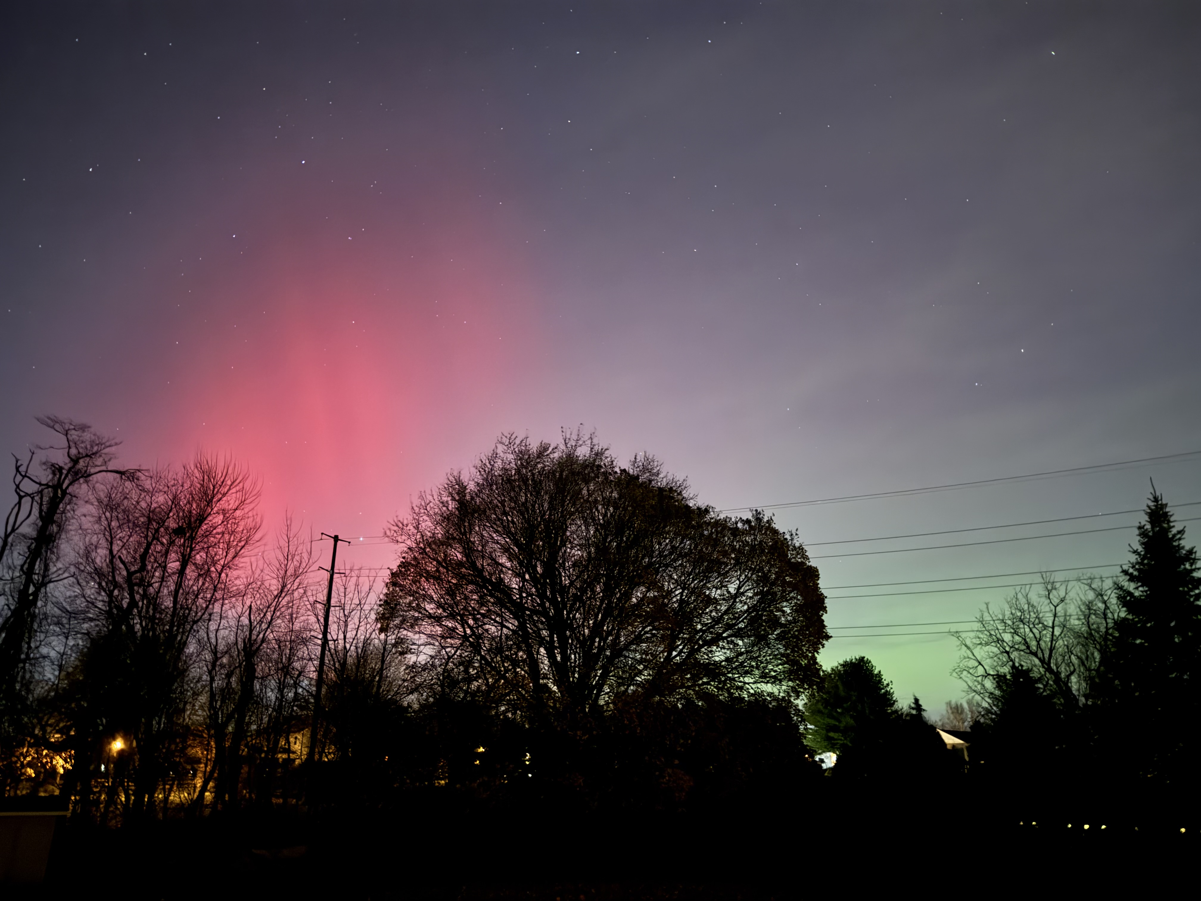
Vivid naked eye aurora visible 10 minutes ago in Allentown!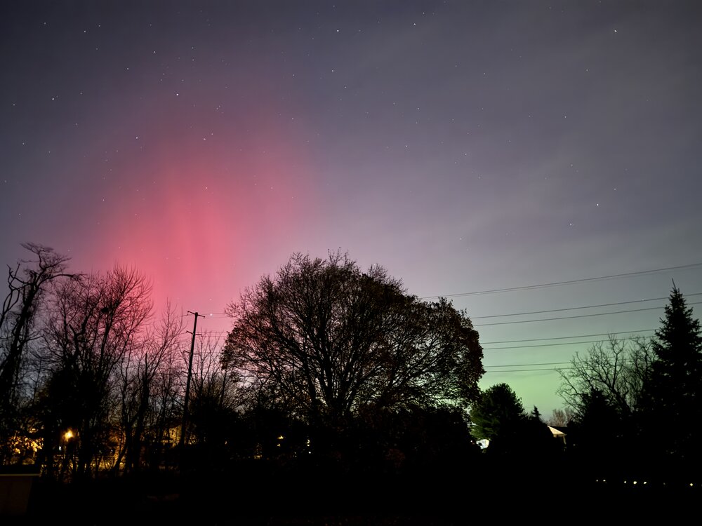
-
E PA/NJ/DE Autumn 2025 Obs/Discussion
LVblizzard replied to PhiEaglesfan712's topic in Philadelphia Region
Clouds cleared a little and believe it or not there’s some naked eye aurora on the horizon! Nothing like last October (yet) but it’s out there! -
E PA/NJ/DE Autumn 2025 Obs/Discussion
LVblizzard replied to PhiEaglesfan712's topic in Philadelphia Region
Aurora visible tonight and it’s freaking cloudy. Ugh… -
E PA/NJ/DE Autumn 2025 Obs/Discussion
LVblizzard replied to PhiEaglesfan712's topic in Philadelphia Region
Looks like most models have something off the coast early next week. The GFS is the only one that gets it cold enough for accumulating snow. At the very least it’s nice to have something to track again.